Embed Size (px)
Citation preview

MulegéGUÍA PARA APRECIAR UN OASIS MEXICANO
GUIDE TO APPRECIATE A MEXICAN OASIS
Marco Antonio Aguirre


GUÍA PARA APRECIAR UN OASIS MEXICANO
Mulegé


Marco Antonio Aguirre
GUÍA PARA APRECIAR UN OASIS MEXICANO
Mulegé

MulegéGuía para apreciar un oasis mexicanoGuide to appreciate a Mexican oasis
1ª edición: Oaxaca, Oax., México. 2008
© 2008 Marco Antonio Aguirre PliegoCaptura: Belén Hernández CristóbalTraducción al inglés: Richard BoilyIlustraciones: Marco Antonio Aguirre PliegoDiseño editorial: Lizeth Arellano Pérez
Prohibida la reproduccion parcial o total sin permiso previo del editor

ÍNDICE
Introducción .................................................Ubicación.......................................................Cómo Llegar ................................................Servicios.........................................................El Paisaje.........................................................El Mar..............................................................Un Monumento Colonial............................Monumentos Prehistóricos........................El Museo Local..............................................Mapas..............................................................
991011121719212528

8
Estado de Baja California Sur
9
Mulegé es una localidad de belleza singular en el estado de Baja California Sur. Descrita como un oasis cuando hay que ser sinté-
ticos; pero, siendo precisos, esa tierra es mucho más que eso.
Este manual se ha concebido como un sencillo homenaje a Mulegé, pero además pretende satisfacer dos objetivos más: el de ser una her-ramienta de apreciación para quienes visiten dicho lugar y un recuerdo del mismo. Ojalá que así sea.
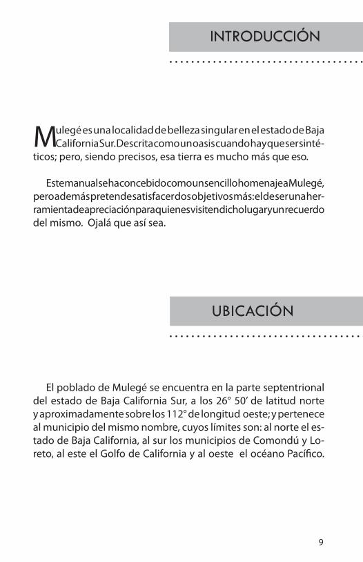
El poblado de Mulegé se encuentra en la parte septentrional del estado de Baja California Sur, a los 26° 50’ de latitud norte y aproximadamente sobre los 112° de longitud oeste; y pertenece al municipio del mismo nombre, cuyos límites son: al norte el es-tado de Baja California, al sur los municipios de Comondú y Lo-reto, al este el Golfo de California y al oeste el océano Pacífico.
INTRODUCCIÓN
UBICACIÓN
10
Desde Tijuana, en autobús, en un viaje de 15 horas de duración, aproximadamente.
Desde Guaymas en un viaje de 6 horas, en un transbordador que atraca en Sta. Rosalía, lugar en el que se transborda a un autobús que hace 40 minutos a Mulegé. Este último medio de transporte sale de Sta. Rosalía a las 16 y a las 19 horas.
Desde La Paz, en autobús, en un viaje de aproximadamente 7 horas.Si se ha tomado la ruta aérea México—Loreto, en la última población mencionada se aborda el autobús —que parte a las 11:30, a las 21:00 y a las 23:00 horas— hacía Mulegé. Su recorrido dura más o menos 2 horas.
CÓMO LLEGAR

11
Mulegé cuenta con hoteles, restaurantes, diferentes tipos de tiendas, transporte especial (terrestre y acuático) a sitios de interés turístico, talleres mecánicos, gasolinera, correo, telégrafo, servicio te-lefónico, talleres de internet, sucursal bancaria, terminal de autobuses, lavandería, farmacias y un hospital.
SERVICIOS
hoteles
Serenidad. Colonia El Cacheno.
Old Hacienda Calle Francisco I. Madero 3
Terrazas Zaragoza s/n
Mulegé General Martínez s/n
Cuesta Real Calle Río Oasis
Las Casitas Francisco I. Madero
Brisas del Mar Calle Playa
La Noria. Carretera Transpeninsular

12
Mulegé tiene un paisaje de grandes contrastes. Su área edificada está en una cañada que hacia el poniente se abre a un valle y hacia el oriente alberga un río que se ensancha conforme se aproxima al mar. El río está flanqueado por espesos palmares en los que predominan las datileras. Fuera de los palmares y del terreno urbanizado, el suelo es un erial de matorrales espinosos que acaban en las húmedas playas.
El azul del mar, la claridad de los cerros erizados con plantas del desierto y el verde del frondoso y serpenteante palmar, hendido por un río, contrastan entre sí de manera dramática bajo la luz del sol que en esta parte del planeta es más intensa. En este sitio, que es un oasis en el contexto de una desértica península, todavía interactúa la gente con muy diversas y vistosas especies de la fauna salvaje. Los animales también integran el paisaje.
Mulegé es un lugar de vistas espléndidas. Hay que irlas descubrien-do; en el flanco noroeste del altozano en el que está emplazado el antiguo templo misional, hay un risco desde el que se contempla el río y el palmar. En cierta época del año las aves marinas, como los rabihor-cados o fragatas (Fregata magnificens), vienen aquí a pescar y, mientras lo hacen, sobrevuelan con majestad el espejo del agua en trayectorias helicoidales que se entrelazan. Eso es un verdadero espectáculo.
Desde el mismo risco se puede contemplar el ocaso. El sol descen-dente va transformando el celaje azul en un manto dorado, y luego
EL PAISAJE
Desembocadura Del Río Mulegé

13
rojo, en el que se perfila la silueta caprichosa de una serranía abundante en cumbres planas tipo meseta; las más notorias son las de los cerros Puerto el Aguajito, San Nicolás y Mesa San Esteban.
Existen muchos otros miradores. De todos ellos dos son impres-cindibles: el primero es la cima del cerro que se encuentra al noroeste del museo local, conocido como La Cananea, al cual se asciende por el sinuoso sendero situado al norte de la calle Moctezuma. Desde este punto se domina, hacia el oeste, el valle de Mulegé. Viendo al este se encuadra el cementerio, el curso bajo el río, el montículo del farito y la inmensa extensión azul del cuerpo líquido del Golfo de California, otrora Mar de Cortés. Por el sur se alcanza a ver el templo misional dedicado a Santa Rosalía de Palermo, conocido popularmente como La Misión; el segundo es el propio montículo sobre el que se desplanta el farito, lugar conocido como El Sombrerito. Desde su cima, de cara al poniente, se tiene una magnífica vista de la desembocadura del río —con su alargada isla Cangrejera—, de la cañada de Mulegé y del muy bien am-bientado hotel Serenidad; a este mirador se llega a través de la ribera norte de dicho río. Mientras se transita por ella uno se deleita, entre otras cosas, contemplando diferentes especies tanto vegetales como de aves que han adoptado la corriente de agua como coto de pesca.
Panorámica de Mulegé

14
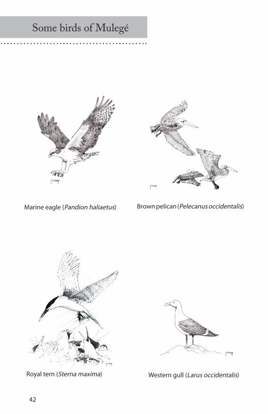
Águila pescadora (Pandion haliaetus) Pelícano pardo (Pelecanus occidentalis)
Golondrina piquinaranja (Sterna maxima) Gaviota occidental (Larus occidentalis)
Algunas aves de Mulegé
15
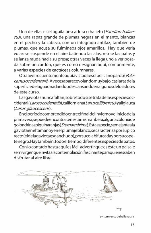
Una de ellas es el águila pescadora o halieto (Pandion haliae-tus), una rapaz grande de plumas negras en el manto, blancas en el pecho y la cabeza, con un integrado antifaz, también de plumas, que acusa su fulmíneos ojos amarillos. Hay que verla volar: se suspende en el aire batiendo las alas, retrae las patas y se lanza rauda hacia su presa; otras veces la llega uno a ver posa-da sobre un cardón, que es como designan aquí, comúnmente, a varias especies de cactáceas columnares.
Otra ave frecuentemente aquí avistada es el pelícano pardo (Pele-canus occidentalis). A veces aparece volando muy bajo, casi a ras de la superficie del agua o nadando o descansando en algunos de los islotes de este curso.
Las gaviotas nunca faltan, sobre todo si se trata de las especies: oc-cidental (Larus occidentalis), californiana (Larus californicus) y aliglauca (Larus glaucescens).
En el período comprendido entre el final del invierno y el inicio de la primavera, se puede encontrar, en esta misma ribera, alguna colonia de golondrinas piquinaranjas (Sterna máxima). Esta especie, semejante a la gaviota en el tamaño y en el plumaje blanco, se caracteriza por su pico recto (el de la gaviota es ganchudo), por su cola bifurcada y por su cope-te negro. Hay también, todo el tiempo, diferentes especies de patos.
Con lo contado hasta aquí es fácil advertir que es éste un paisaje semivirgen que invita a la contemplación, fascinante para quienes saben disfrutar al aire libre.
avistamiento de ballena gris

16
Animales marinos de Mulegé
Delfín nariz de botella (Tursiops truncatus)
Jurel (Seriola mazatlana)
León marino (Zalophus californianus)

17
La ribera conduce a la playa y la playa al mar. La playa de Punta Prieta es pedregosa y en la de El Gallito hay médanos.
La plataforma marina costera, frente a Mulegé, es extensa y de poca profundidad, lo que implica contar con un mar de agua clara; un mar de encantadora transparencia; un mar de condiciones ideales para la práctica tanto del snorkel como del buceo con tanque.
En estas aguas se practica también la navegación en kayak. Ahora que si opta uno por un paseo en lancha con motor fuera de borda –hay quienes dan este servicio– el destino recomendado es la isla Santa Inés, situada aproximadamente a 11.50 km. al noreste de la desembocadura del río Mulegé. Dicha isla es un refugio de la fauna silvestre. Árida, rocosa y blanqueada por el guano de las aves que en ocasiones ahí habitan, da cobijo también a grupos de leones marinos (Zalophus cali-fornianus), conocidos como loberías.
Mientras se navega a la isla, se puede distinguir el fondo del mar alunarado por esponjas, caracoles y erizos, iluminados de azul turquesa o verde aguamarina por la luz que ha penetrado en el estrato acuoso. Y casi es seguro que, en el trayecto, la lancha será acompañada por un juguetón grupo de delfines nariz de botella (Tursiops truncatus), que saltarán, transitarán por debajo del casco de la embarcación rozándolo y nadarán por delante de proa como escoltando al visitante.
En los días calurosos, los pinnípedos miembros de la lobería pasan la mayor parte del tiempo metidos en el agua. Sólo sacan sus cabezas y las aletas anteriores. En los días fríos yacen en tierra firme tomando baños de sol.
No ha faltado en alguna ocasión, en el invierno, en esta misma co-marca marina, el encuentro con un solitario ejemplar de ballena gris (Eschrichtius robustus) extraviado, activando insistente su sonar, para encontrar la ruta de regreso al lugar de su rebaño.
A poca distancia del estuario es frecuente hallar algunos barcos ca-maroneros y embarcaciones, aún más pequeñas que los primeros, de-dicadas a la pesca comercial de especies tales como mojarra, lenguado, jurel y otras también comestibles.
EL MAR

18
Sin interferir con esta actividad se puede practicar la pesca deportiva o, en el más simple de los casos, sin equipo especializado, puede uno dedicar un medio día a la recolección de almejas en alguna de las playas muleginas.
Otra actividad recreativa, si ya se han venido observando las aves desde la ribera, es continuar con esto en el estuario y en la playa, en donde es más amplia la población tanto de gaviotas como de pelíca-nos. Los últimos se agrupan, por ejemplo, en las orillas inmediatas al Sombrerito, formados en rítmicas alineaciones que parecen haber sido racionalmente concebidas.
Mulegé es el punto de partida ideal para las excursiones a la bahía Concepción, debido a la proximidad existente entre estos dos puntos (20 km. en promedio). Muchos excursionistas acampan en las playas de esta bahía, y sinceramente esa es una opción excelente, teniendo en cuenta que la bahía Concepción es un lugar de belleza extraordinaria; sus aguas, de color turquesa en las orillas y azul marino en el centro cuando se ven desde lejos, son tan tranquilas y claras como las de una piscina; y contrastan de manera rotunda con las moderadamente eleva-das tierras de conformación cenozoica que las rodean.
Viajando hacía el sur, la primera playa recomendable de la bahía es la de Santispac, inmediatamente al poniente de Punta Piedrita y frente al islote San Ramón. Después encuentra uno la de El Coyote, frente a la isla del mismo nombre. Cerca de esta playa hay un venero de agua termal; y, tierra arriba, también cerca de la playa, hay un pequeño nicho rocoso con vestigios de pintura rupestre.
La playa famosa más austral de la bahía es la de El Requesón; dife-rente a las dos anteriores mencionadas, pues arranca de ella, perpendi-cularmente, una lengüeta de tierra firme, con arena de blancura nívea, que conecta con un islote de matorrales xerófilos. La naturaleza nos sorprende con su plástica de caprichos audaces.
19
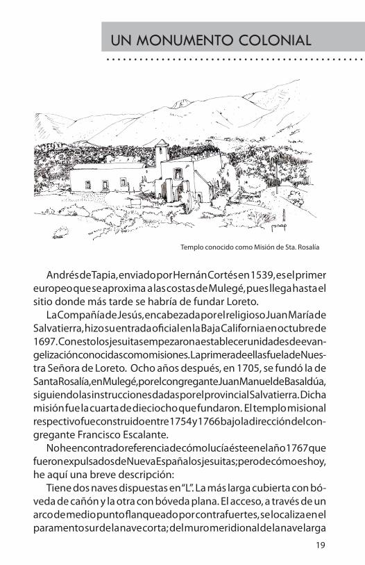
Andrés de Tapia, enviado por Hernán Cortés en 1539, es el primer europeo que se aproxima a las costas de Mulegé, pues llega hasta el sitio donde más tarde se habría de fundar Loreto.
La Compañía de Jesús, encabezada por el religioso Juan María de Salvatierra, hizo su entrada oficial en la Baja California en octubre de 1697. Con esto los jesuitas empezaron a establecer unidades de evan-gelización conocidas como misiones. La primera de ellas fue la de Nues-tra Señora de Loreto. Ocho años después, en 1705, se fundó la de Santa Rosalía, en Mulegé, por el congregante Juan Manuel de Basaldúa, siguiendo las instrucciones dadas por el provincial Salvatierra. Dicha misión fue la cuarta de dieciocho que fundaron. El templo misional respectivo fue construido entre 1754 y 1766 bajo la dirección del con-gregante Francisco Escalante.
No he encontrado referencia de cómo lucía éste en el año 1767 que fueron expulsados de Nueva España los jesuitas; pero de cómo es hoy, he aquí una breve descripción:
Tiene dos naves dispuestas en “L”. La más larga cubierta con bó-veda de cañón y la otra con bóveda plana. El acceso, a través de un arco de medio punto flanqueado por contrafuertes, se localiza en el paramento sur de la nave corta; del muro meridional de la nave larga
Templo conocido como Misión de Sta. Rosalía
UN MONUMENTO COLONIAL

20
emerge la torre del campanario, coronada por un cuerpo piramidal que se asemeja un poco al de los campaniles de estilo románico de la región lombardo-catalana; los muros exteriores son de sillares de piedra apa-rente o expuesta; la obra lapídea carece de ornamentación, pero no obstante toda esta franca austeridad, este templo es el principal edificio emblemático de Mulegé.
Vista aérea del viejo templo misional jesuita
21
Los Jesuitas que llegaron a Baja California en la época colonial co-nocieron algunos de sus lugares de pintura rupestre. Francisco Xavier Clavijero, en su libro “Historia de la Antigua o Baja California”, al res-pecto escribió:
Pero atendiendo a los pocos vestigios de antigüedad que allí han quedado, es fácil persuadirse que aquella vasta península estuvo antes habitada por gentes menos bárbaras que las que hallaron en ella los españoles; porque los jesuitas, en los últimos años que estuvieron allí, descubrieron en los montes situados entre los 27° y 28° de latitud, varias cuevas grandes cavadas en piedra viva, y en ellas pintadas figuras de hombres y mujeres decentemente vestidas, y de diferentes especies de animales. Estas pinturas, aunque groseras, representan distintamente los objetos, y los colores que para ellas sirvieron, se echa de ver clara-mente que fueron tomados de las tierras minerales que hay en los alrededores del volcán de las Vírgenes. Lo que más admiró a los misioneros fue que aquellos colores hubiesen permanecido en la piedra por tantos siglos sin recibir daño alguno ni del aire ni del agua. 1
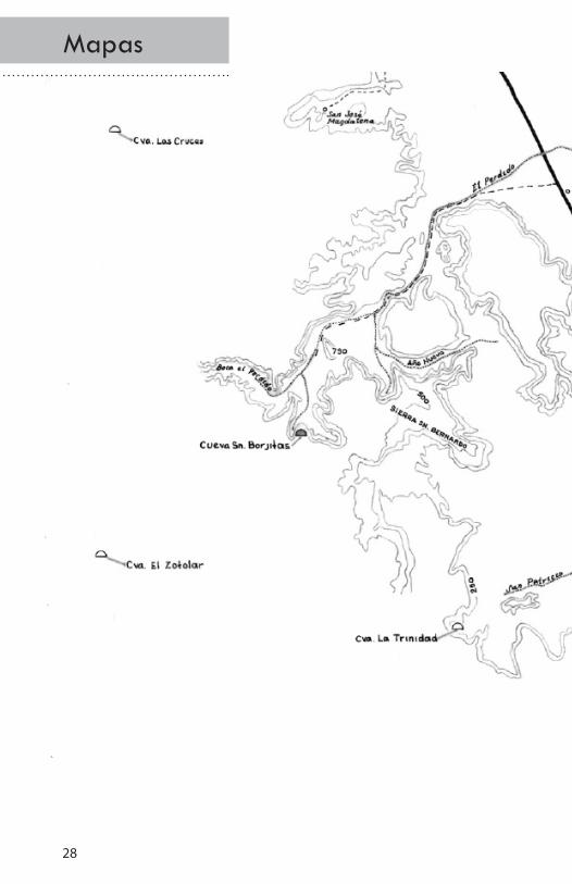
De los 543 sitios con arte rupestre registrados por el I.N.H.A. en el año 2003, dos son accesibles desde el poblado de Mulegé, y son los siguientes: la cueva San Borjitas y el nicho rocoso La Trinidad. La prime-ra situada al oeste, haciendo un rodeo de 73 km. por el noroeste del poblado; y el segundo, 20 km. al suroeste del mismo punto de partida. Para llegar a la cueva San Borjitas, partiendo del punto en cuestión, hay que recorrer por la carretera transpeninsular 18 kilómetros hasta la ranchería denominada Palo Verde.
En este punto abandona uno dicha carretera dando vuelta hacia el poniente y, a través de un camino de terracería, se llega hasta un sitio conocido como El Perdido. A partir de ahí se entra en una cañada y se transita sobre el lecho pedregoso del arroyo, también llamado El Perdi-do, hasta el rancho del señor Jaime Gorosave, donde se hace el registro de visitantes y se paga la cuota de admisión.
MONUMENTOS PREhISTÓRICOS
1Francisco Xavier Clavijero. Historia de la Antigua o Baja California. Porrúa. México, 1990. p. 48,49.

22
Cueva San Borjitas

23
Durante el trayecto a este sitio se pueden ver distintas especies de xerófitas entre las que destacan el cardón, la pitahaya y la biznaga (Ferocactus acanthodes). Entre los arbustos del área se encuentran la gobernadora (Larrea tridentata) y el palo verde (Cercidium microphy-llum), y entre los subarbustos, la damiana (Turnera diffusa).
Las incomodidades de este viaje se compensan, antes de alcanzar su objetivo, con algunos atractivos del paisaje, como lo es, por ejemplo, un paraje cercano a Uña de Gato en el que abunda una herbácea —que ahí crece hasta un metro de alto— de hojas pennadas de color verde cenizo y bordes espinosos, conocida en algunas partes del país como chicalote y en otras como cardo. Esta planta, en invierno, florece en tal medida que satura visualmente el ambiente con infinidad de corolas blancas que contrastan con el fondo azul de los cerros circundantes. Vale la pena detenerse ahí un momento.
A la cueva San Borjitas se llega caminando en ascenso. Ésta se en-cuentra en el risco de un angosto cañón. Su boca es amplia, pues mide poco más de 30 metros; de fondo tiene 34 m. aproximadamente; la altura en la boca es, más o menos, de 3.50 m. y ésta va descendiendo hacia el fondo; la pintura en su bóveda cubre un área de más de 200 metros cuadrados y los motivos son figuras humanas asaeteadas o al-canzadas por lanzas; el tamaño de ellas es de una escala muy próxima a la natural. Las figuras están representadas de frente, con las extremida-des extendidas; sus chatas cabezas sin cuello, apuntan en diversas direc-ciones; algunas de las figuras se traslapan. Por lo que respecta al color, unas están realizadas en rojo y otras ostentan medio cuerpo en negro y medio cuerpo en rojo, en sentido vertical. En un área más profunda de la cueva hay un venado, asaeteado también, en líneas blancas, sobre un fondo que parece negro de humo. La forma en la que están plasmadas estas figuras, para Harry W. Crosby, autoridad en la materia, constitu-ye uno de los cinco estilos de pintura rupestre que él distingue en la península: el estilo San Borjitas. Los otros cuatro estilos que él enuncia, son: rojo sobre granito, San Francisco, Trinidad y semiabstracto.

24
Las características del estilo San Borjitas son las siguientes:
Predominancia de figuras humanas de complexión bulbosa, piernas tiesas pero despegadas, brazos extendidos. No tienen cuello. Sus cabezas son de remate plano con aspecto de bote. Mayormente estas figuras están decoradas con rayas verticales, pero también llegan a verse con rayas horizontales. Tienen áreas bicoloreadas en sentido vertical y, ocasionalmente, motas. 2
Se ha especulado acerca del significado de la pintura de esta cueva. Se ha dicho, por ejemplo, que representa enemigos sacrificados o que, por el contrario, son los propios líderes del grupo que pintó, los que aquí aparecen muertos. Harry W. Crosby opina que la escena simboliza el arte de la guerra entre las sierras que hoy llamamos Guadalupe y San Francisco, respectivamente. Como quiera que sea, indudablemente, el tema se refiere a la mortalidad del ser humano.
Los estudiosos de esta obra nos hacen ver que las figuras se fueron pintando en etapas de un período prolongado, de manera que no to-das tienen la misma antigüedad.
Los análisis realizados por investigadores de México, Argentina y Australia, sobre la representación más antigua, revelaron que ésta fue ejecutada hace 7500 años. Siete mil quinientos años. Hay que repetirlo porque se trata de otro tiempo, de otro mundo, de otra cosmovisión; sintetizada y expresada con gran sentimiento. Se trata de un sentimien-to sempiterno hecho imagen que nos asombra en extremo.
En el abrigo rocoso de La Trinidad hay dos grupos de impresiones de manos en multiplicidad. Uno de ellos de manos de niño. Hay una figura humana representada en forma elemental, peces, un coyote y venados en diferentes posiciones y tamaños; en los últimos se advierte una hábil ejecución. La imaginería de La Trinidad se caracteriza por ser más lineal que pictórica. Podría decirse que se trata de dibujo con aplicaciones de color. También hay petroglifos.
² Harry W. Crosby. The Cave Paintings of Baja California, Discovering the Great Murals of an Unknown People. Sunbelt Publications. San Diego, California, 1977. p. 213,214.

25
EL MUSEO LOCAL
El edificio que ocupa el museo de Mulegé se construyó en los albo-res del siglo veinte, y fue originalmente cárcel. Es el segundo edificio emblemático de la localidad. En los recintos inmediatos a su acceso se exhiben diversos objetos del pasado no sólo del pueblo, sino inclusive de la región.
En la parte posterior del inmueble están las ruinas de las otrora celdas. El salón situado hacia el poniente contiene algunos objetos do-mésticos del siglo diecinueve: planchas a base de carbón, molinos para café y otros utensilios de fierro colado. En una de las paredes destaca una fotografía, de mediano tamaño, de Erle Stanley Gardner, novelista estadounidense y explorador de Baja California Sur a principios de la década 1960. Aunque hay que decir que la mejor colección de foto-grafías históricas no está aquí. Ésta la tiene el señor Noé Miranda quien, en su lavandería de la calle Zaragoza, expone parte de ella. Él, prácti-camente, es el cronista de Mulegé.
Vista parcial del museo local

26
Volviendo a la descripción del museo, en el salón intermedio se ex-hiben espadas, fusiles y un par de cañones, también del siglo diecinueve. En la sala del extremo oriente se pueden ver objetos muy diversos como puntas pétreas de flechas, metates, una pequeña red, de hechura muy fina, encontrada en la sierra Guadalupe. A estos artefactos de la prehistoria del pueblo cochimí, se suman: una enorme tortuga marina disecada, el casco carcomido de lo que alguna vez fue un esquife y una pesada escafandra metálica de buzo, quizá de uno de aquellos que bu-scaban perlas en aquella época en la que decían que éstas abundaban.
En el pasillo hay una interesante colección de conchas fosilizadas de moluscos.
Paleontología, arqueología e historia, son los tres hilos de la urdim-bre modesta pero interesante de este museo.
Colección de pesca y buceo del museo local

27
Algunas plantas de Mulegé
Pitaya dulce (Stenocereus thurberi) Chicalote (Argemone ochroleuca)
(Echinocactus visnaga)
Biznagas
(Ferocactus acanthodes)
28
Mapas
29
Maps

30

31

32
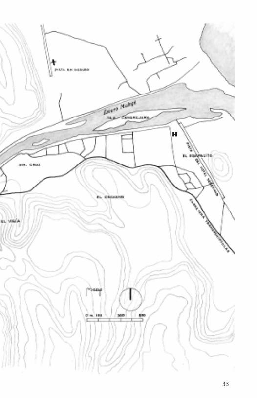
H
33
H

34

35

36
State of Baja California Sur

37
Mulegé is a place of singular beauty in the state of Baja Cali-fornia Sur. Described as an oasis when one has to synthe-
size; but precisely, this land is much more than that.This manual has been conceived as a simple tribute to Mulegé,
but moreover claims to satisfy two more objectives: that of being a tool of appreciation to whoever visits here and a souvenir of it. Hopefully that will be the way it is.
The town of Mulegé is found in the northern part of the state of Baja California Sur, at 26° 50’ latitude north and approximately on the 112° longitude west; and is part of the municipality of the same name, whose limits are: to the north the state of Baja California, to the south the municipalities of Comondú and Loreto, to the east the Gulf of California and to the west the Pacific ocean.
INTRODUCTION
LOCATION
GUDE TO APPRECIATE A MEXICAN OASIS
Mulegé

38
A bus ride from Tijuana is approximately 15 hours duration.From Guaymas, it’s a 6 hour trip, by boat which puts ashore
in Sta. Rosalía, where you board a bus which takes 40 minutes to Mulegé. The bus leaves Sta. Rosalía at 16 and 19 hundred hours.
From La Paz, by bus, the trip is approximately 7 hours.If you took México-Loreto by air, when you arrive at destina-
tion, you board a bus —which leaves at 11:30, 21:00 or 23:00 hours— to Mulegé. The ride is more or less 2 hours.
HOW TO GET THERE

39
SERVICES
Mulegé has hotels, restaurants, different types of stores, special types of transport (terrestrial and aquatic) to sites of tourist in-terest, mechanic shops, gas stations, post office, telegraph office, phone service, internet service, bank branches, bus terminals, laun-dries, pharmacies and a hospital.
Hotels
Serenidad. Colonia El Cacheno.
Old Hacienda Calle Francisco I. Madero 3
Terrazas. Zaragoza s/n.
Mulegé General Martínez s/n.
Cuesta Real. Calle Río Oasis
Las Casitas. Francisco I. Madero Brisas del Mar Calle Playa
La Noria Carretera Transpeninsular.

40
Mulegé has a landscape of great contrasts. It’s built up area is in a gulch which, to the west, opens up to a valley; and to the east, harbours a river which widens as it nears the sea.
The river is flanked by species of palm trees of which predomi-nates the date palm. Apart from the palm trees and the urbanized areas, the land is uncultivated, populated by prickly shrubs, and terminates at the humid beaches.
The blue sea, the clear mountains bristling with desert plants, the green background of the serpentine palm grove, all rifted by a river, contrast dramatically under the sun light that this part of the planet is more intensive.
This site, which is an oasis in the context of a desert peninsula, yet the people interact with beautiful and divers species of wildlife. The animals are also part of the landscape.
Mulegé is a place of splendid sights. One has to go and discover them; in the north eastern flank of the highland, where there is an ancient missionary church, there is a steep rock cliff where you can look upon the river and the palm trees. At certain times of the year, sea birds like the frigatebirds (Fregata magnificens), come here to fish, and while they fish, fly majestically over the mirror of water in spiralling trajectories that interlace. It is a true spectacle.
THE LANDSCAPE
Mouth of the Mulege river

41
From the same steep rock cliff you can view the sunset. The setting sun transforms the blue sky to a golden mantle, and later red, in which the whimsical silhouette profile of the mountains is abundant in flat table top like summits; the most notorious are those of the Puerto el Aguajito, San Nicolás and Mesa San Este-ban mountains.
There exist many more lookouts. Of them all two are indispens-able: the first is the summit of the mountain that’s found to the northeast of the local museum, known as La Cananea, of which one climbs to by a sinuous trail situated to the north of Moctezuma Street. From this summit towards the west, one dominates the val-ley of Mulegé. Looking towards the east one sees the cemetery, the trajectory of the river, the lighthouse built on a rocky outcrop and the immense extension of the blue water that is the Golf of California, or Mar de Cortés. Towards the south one can see the missionary church dedicated to Santa Rosalía de Palermo, better known as La Misión; the second is the rocky outcrop on which the lighthouse sits, better known as El Sombrerito. From its summit on the western face, you have a magnificent view of the mouth of the river —with its large Cangrejera island— the Mulegé gulch and the Hotel Serenidad with its very nice atmosphere; one gets to this
Panoramic view of Mulege
42
Marine eagle (Pandion haliaetus) Brown pelican (Pelecanus occidentalis)
Royal tern (Sterna maxima) Western gull (Larus occidentalis)
Some birds of Mulegé

43
lookout from the north shore of the river. While one is transiting this shore one delights, amongst other things, contemplating not only different species of plants but birds as well that have adapted the water current as a place for fishing. One of them is the osprey or marine eagle (Pandion haliaetus), a large raptor with a coat of black feathers and white on the chest and head, with an integrated antiface, also of feathers, which cause his yellow eyes to explode. One must see it fly: it suspends itself in the air flapping its wings, retracting its feet and streaks towards its prey; other times one can see it standing on a teasel, as is designated here, common to differ-ent species of columnar cacti.
Another bird frequently seen here is the brown pelican (Pele-canus occidentalis). Sometimes it is seen flying very low, almost touching the water or swimming or resting on some of the small islands of this river flow.
The sea gulls are never missing, especially the species: Western (Larus occidentalis), Californian (Larus californicus) and Glau-cous—winged (Larus glaucescens).
In the period between the end of winter and the beginning of spring, one can find, on this same shore line, some colonies of royal terns (Sterna maxima). This species, similar to the gulls in size and wiht white feathers, are characterized by their straight beaks (the beak of the gull is hooked), split tail and black crown. There are as well all the time different species of ducks.
With all that has been said up to now it’s easy to say that this is a semi virgin landscape that invites contemplation, fascinating for those that know how to enjoy the open air.
Catch sight of gray whales

44
Sea animals of Mulegé
Bottle nosed dolphin (Tursiops truncatus)
Jurel (Seriola mazatlana)
Sea lion (Zalophus californianus)

45
The shore line leads to the beach and the beach to the sea. The Punta Prieta beach is stony and El Gallito beach has sand dunes.
The costal sea platform, in front of Mulegé, is extensive and shallow, which implies a sea of clear water; a sea of delightful trans-parency; a sea with ideal conditions for snorkelling as well as aqua-lung diving. In these waters one can also practice kayaking. Now, if one opts for an offshore motor boat tour -there are those that offer this service- the recommended destination is Santa Inés is-land, situated approximately at 11.50 km. northeast of the mouth of the Mulegé river.
This island is a refuge for wildlife. Arid, rocky, and bleached by the guano from the birds which on occasion live here, also gives shelter to groups of sea lions (Zalophus californianus), known as loberías.
While one is navigating the island, one can distinguish the sea bottom spasmodic with sponges, conches and urchins, illuminated of blue turquoise and aquamarine by the light which has penetrat-ed the watery stratum. And it is almost sure that the boat, along its course, will be accompanied by a group of playful bottle nosed dolphins(Tursiops truncatus), which jump, passing underneath the hulk of the embarkation grazing it and swimming ahead of the prow like an escort to the visitor.
On hot days, seal members of the sea lion group pass most of the time in the water. They only lift their heads and their back flip-pers above the water. On cold days they stay on firm ground taking sun baths.
There has been on some occasion, in winter, in this same ma-rine boundary, an encounter with a wayward solitary grey whale (Eschrichtius robustus), insistently activating its sonar, to find the route to return to its herd.
A short distance from the estuary one frequently finds shrimp
THE SEA

46
boats and embarkations, even smaller than the aforementioned, dedicated to commercial fishing of species like bass, sole, jurel and others also edible.
Without interfering with those activities one can take up sports fishing or, in the most simple of cases, without specialized equip-ment, one can dedicate half a day to collect clams on some of the beaches of Mulegé.
Another recreational pastime, if one has been observing the birds from the shoreline, is to continue with this activity on the estuary and the beach, where there is a more ample population not only gulls but of pelicans as well. These last for example, group themselves on the immediate shore of the Sombrerito, forming rhythmic lines which appear to have been rationally conceived.
Mulegé is the ideal departure place for excursions to Concep-ción Bay, due to the proximity between these two points (20 km, in average). Many excursionists camp on the beaches of the bay, and sincerely it is an excellent option, taking in consideration that Con-cepción Bay is a place of extraordinary beauty; its waters, turquoise in colour at the edges and dark blue at the centre when seen from afar, are so calm and clear like those of a swimming pool; and con-trast in a rotund manner with the moderately elevated landscape of cenozoic conformation which encircles it.
Travelling south, the first recommended beach on the bay is Santispac, immediately west of Punta Piedrita and in front of the small San Ramón island. Afterwards one comes across El Coyote, in front of the small island of the same name. Near this beach there is a thermal spring; and, on high ground, also near the beach, there is a small rocky niche with vestiges of cave paintings.
The most southern beach of the bay is the famous El Requesón; different from the two aforementioned, since starting from it, per-pendicularly, a tongue of firm land, with sand as white as snow, connects with a small island of dry land shrubs. Nature surprises us with its audacious plastic fancy.

47
Andrés de Tapia, sent by Hernán Cortés in 1539, is the first European to near the coasts of Mulegé, since he arrived at the place where later he would found Loreto.
The Society of Jesus, led by the religious Juan María de Salvati-erra, made their official entry in Baja California in October 1697. With that, the Jesuits began to establish evangelization units known as missions. The first of those was Nuestra Señora de Loreto. Eight years later, in 1705, was founded Santa Rosalía, in Mulegé, by the congregationist Juan Manuel de Basaldúa, following the instruc-tions given by the provincial Salvatierrra. The aforementioned mis-sion was the fourth of eighteen which were founded. The respec-tive mission churches were built between 1754 and 1766 under the direction of the congregationist Francisco Escalante.
I have not found any reference of how it looked in 1767 when the Jesuits were expulsed from New Spain; but the way it is today, here is a brief description:
They have two naves arranged in “L”. The largest covered by an arched vault and the other with a flat vault. Access was through an arch midway, flanked by counter forts, localized in the south wall of
A COLONIAL MONUMENT
Church known as Misión Sta. Rosalía
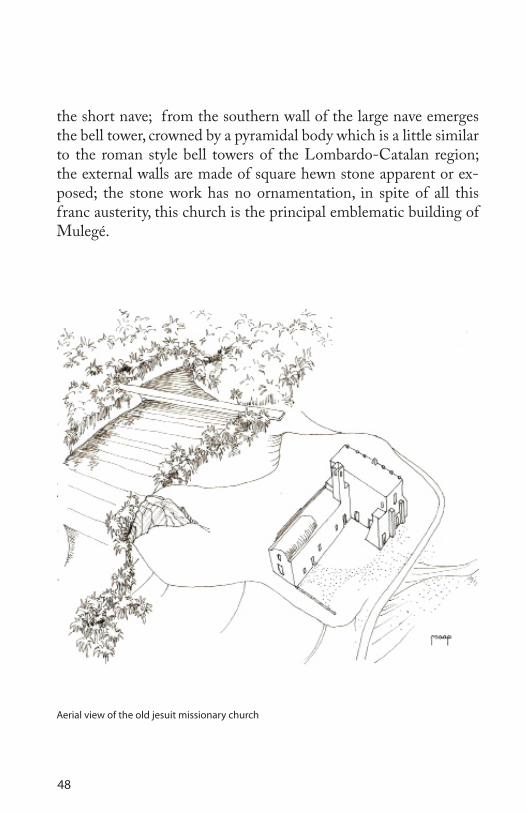
48
the short nave; from the southern wall of the large nave emerges the bell tower, crowned by a pyramidal body which is a little similar to the roman style bell towers of the Lombardo-Catalan region; the external walls are made of square hewn stone apparent or ex-posed; the stone work has no ornamentation, in spite of all this franc austerity, this church is the principal emblematic building of Mulegé.
Aerial view of the old jesuit missionary church

49
The Jesuits that arrived in Baja California during the colonial period knew some of its places of cave paintings. Francisco Xavier Clavijero, in his book “Historia de la Antigua o Baja California”, with respect wrote:
But attending the few vestiges of antiquity which are found there, it’s easy to persuade oneself that this vast peninsula was prior populated by people less barbarous than those found there by the Spaniards; because the Jesuits, in the last years that they were there, discovered in the hills situated between 27° and 28° latitude, various large caves hewn from living rock, and inside painted with figures of men and women decently dressed, and of different species of animals. These paintings al-though gross represented distinctly the objects, and the colours that for them were useful, can clearly be seen to be taken from the mineral soil that is found in the surroundings of the Virgenes volcano. What I most admire of the missionaries was that those colours stayed in the rock for so many cen-turies, without any damage neither from the air or water.¹
Of the 543 sites with cave art registered by the I.N.H.A. in the year 2003, two are accessible from the town of Mulegé, and are the following: the San Borjitas cave and the La Trinidad rocky niche. The first situated to the west, in a circuitous way 73 km. northeast of the town; and the second, 20 km. to the southeast of the same point of departure. To arrive at the San Borjitas cave, leaving from the point in question, one has to take the transpininsular highway 18 kilometers to a ranch called Palo Verde.
At this point one leaves the highway turning towards the west, and using a dirt road, one arrives at a place known as El Perdido. Leaving from there one enters a gulch and one transits on the edge of a stony river bed, also called El Perdido, until the ranch of mister Jaime Gorosave, where visitors register and pay an admission fee. During the trajectory to this site one can see distinct species of cacti amongst which are the teasel, the pitaya and the head cactus (Ferocactus acanthodes).
PREHISTORIC MONUMENTS
1 Francisco Xavier Clavijero. Historia de la Antigua o Baja California. Porrua. México, 1990. p 48,49.

50
San Borjitas cave

51
Among the shrubs of the area one finds the governor (Larrea tridentada) and the green post (Cercidium microphylum), and among the small shrubs, the damiana (Turnera diffusa).
The incommodities of this trip are compensated, before reaching your objective, with some attractive landscape, such as, for example, a lookout near Uña de Gato where there are herbs in abundance -that here grow to a meter tall– with leafs of ash green colour, and spiny extremities, known in certain parts of the country as chi-calote, and in other parts as thistle. This plant, in winter, flowers to such an extent that it visually saturates the environment with an infinity of white petals that contrast with the blue background of the surrounding mountains. It is worth while to pause there for a moment.
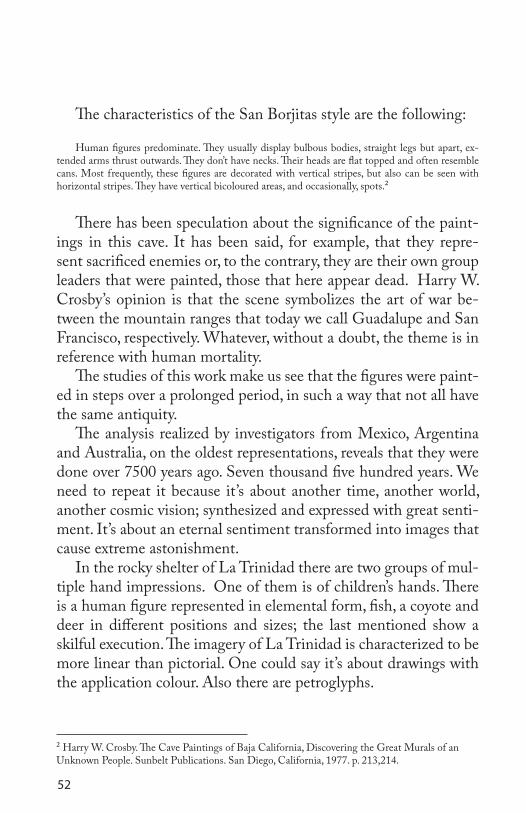
The San Borjitas cave is reached walking upwards. It is found on the cliff of a narrow canyon. The mouth is ample since it measures a little more than 30 m.; the depth is approximately 34 m.; the height of the mouth is, more or less, 3.50 m. and descends to the depth; the paintings on the apse covers an area of more than 200 square meters and the motifs are human figures pierced by arrows or reached by spears; their size is on a scale approximately to the normal; the figures are represented front wise, with the extremities extended; their flat heads without a neck, point in divers direc-tions; some of the figures are superimposed. As with respect to the colour some are in red others are shown with half the body in black and half in red, in a vertical orientation. In a deeper area of the cave there is a deer, pierced by arrows also, with white lines, on a background which appears black from smoke. The form in which these figures are shown, according to Harry W. Crosby, authority on the subject, constitutes one of the five styles of cave paintings that he distinguishes in the peninsula: the San Borjitas style. The other four styles that he puts forward are: red on granite, San Fran-cisco, Trinidad and semi abstract.
52
The characteristics of the San Borjitas style are the following:
Human figures predominate. They usually display bulbous bodies, straight legs but apart, ex-tended arms thrust outwards. They don’t have necks. Their heads are flat topped and often resemble cans. Most frequently, these figures are decorated with vertical stripes, but also can be seen with horizontal stripes. They have vertical bicoloured areas, and occasionally, spots.²
There has been speculation about the significance of the paint-ings in this cave. It has been said, for example, that they repre-sent sacrificed enemies or, to the contrary, they are their own group leaders that were painted, those that here appear dead. Harry W. Crosby’s opinion is that the scene symbolizes the art of war be-tween the mountain ranges that today we call Guadalupe and San Francisco, respectively. Whatever, without a doubt, the theme is in reference with human mortality.
The studies of this work make us see that the figures were paint-ed in steps over a prolonged period, in such a way that not all have the same antiquity.
The analysis realized by investigators from Mexico, Argentina and Australia, on the oldest representations, reveals that they were done over 7500 years ago. Seven thousand five hundred years. We need to repeat it because it’s about another time, another world, another cosmic vision; synthesized and expressed with great senti-ment. It’s about an eternal sentiment transformed into images that cause extreme astonishment.
In the rocky shelter of La Trinidad there are two groups of mul-tiple hand impressions. One of them is of children’s hands. There is a human figure represented in elemental form, fish, a coyote and deer in different positions and sizes; the last mentioned show a skilful execution. The imagery of La Trinidad is characterized to be more linear than pictorial. One could say it’s about drawings with the application colour. Also there are petroglyphs.
² Harry W. Crosby. The Cave Paintings of Baja California, Discovering the Great Murals of an Unknown People. Sunbelt Publications. San Diego, California, 1977. p. 213,214.

53
The building that occupies the museum of Mulegé was built at the dawn of the 20th century, and was originally a prison. It’s the second emblematic building of the area. In the immediate pre-cincts to its access are exhibited objects from the past not only of the town, but also inclusive of the region.
At the rear of the building are the ruins of other cells. The west hall contains some domestic objects from the 19th century: carbon based slabs, coffee grinders and other utensils of strained steel. On one of the walls there is a photograph of medium size, of Earl Stanley Gardner, an American novelist and explorer of Baja Cali-fornia Sur at the beginning of the 1960’s. Although, it must be said, that the best collection of historical photographs is not found here. Mister Noé Miranda has it, which, in his laundry on Zara-goza Street, is shown part of it. He practically is the chronicler of Mulegé.
THE LOCAL MUSEUM
Partial view of the local museum

54
Returning to the description of the museum, in the intermediate hall swords are exhibited, guns and a pair of cannons, also from the 19th century. In the hall at the extreme east, very divers objects can be seen like stone arrow heads, pistils, a small net very finely made and found in the Guadalupe mountain range. To those prehistoric artefacts of the Cochimi people, we add: an enormous dissected marine turtle, a worm-eaten hulk that was at one time a skiff and a heavy metal diving suit, perhaps one of those used to look for pearls at a time when it was said that they were abundant.
In the corridor there is an interesting collection of fossilized sea shells.
Palaeontology, archaeology and history, are the three threads of the modest chain but of interest about this museum.
Local museum fishing and diving collection
55
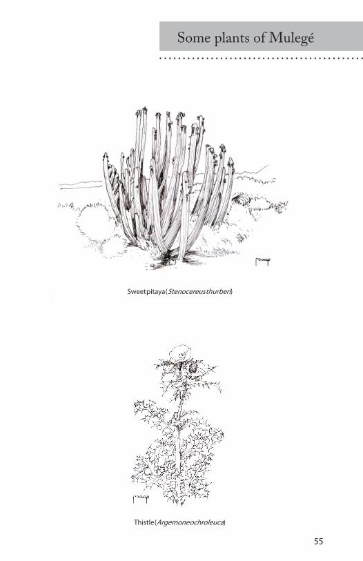
Some plants of Mulegé
Sweet pitaya (Stenocereus thurberi)
Thistle (Argemone ochroleuca)

56
Barrel cactus(Echinocactus visnaga)
Head cactus(Ferocactus acanthodes)
Bishop’s weeds
Introduction.............................................37Location...................................................37How To Get There...................................38Services.................................................... 39The Landscape..........................................40The Sea.....................................................45A Colonial Monument.............................47Prehistoric Monuments............................49The Local Museum..................................53Maps........................................................28
INDEX

EDICIÓN LIMITADALIMITED EDITION


Mulegé es una localidad de belleza singular en el estado de Baja California Sur. Descrita como un oasis cuando hay que ser sintéticos; pero, siendo precisos, esa tierra es mucho más que eso.
Este manual se ha concebido como un sencillo homenaje a Mulegé, pero además pretende satisfacer dos objetivos más: el de ser una herramienta de apreciación para quienes visiten dicho lugar y un recuerdo del mismo. Ojalá que así sea.
Mulegé is a place of singular beauty in the state of Baja California Sur. Described as an oasis when one has to synthesize; but precisely, this land is much more than that.
This manual has been conceived as a simple tribute to Mulegé, but moreover claims to satisfy two more ob-jectives: that of being a tool of appreciation to whoever visits here and a souvenir of it. Hopefully that will be the way it is.
Marco Antonio Aguirre Pliego es arquitecto por la U.N.A.M (1975), profesor jubilado de la Universidad Autónoma “Benito Júarez” de Oaxaca (2006) y miembro correspondiente del Seminario de Cultura Mexicana desde 1994.


![El Concebido[1]](https://img.pdfslide.es/doc/110x75/577c80af1a28abe054a9bf7e/el-concebido1.jpg)