Embed Size (px)
Citation preview

8/21/2019 BCRA 14-3-1987
http://slidepdf.com/reader/full/bcra-14-3-1987 1/52
a Science
The Transactions o the British
Cave
Research ssociation
BeR
I
olume 14
Number
December 987
I
M2 Cave Picos
de Europa Spain
B.C.R.A. Symposium abstracts
Ankarana Caves Madagascar
Caves
of
Glomdal Norway
Caves and Mines of Hawkstone Park
Leptospi ros is among Bri t ish
Cavers
8/21/2019 BCRA 14-3-1987
http://slidepdf.com/reader/full/bcra-14-3-1987 2/52
ave
Science
The
Transac t ions of
the
Br i t i sh
Cave
Research
covers
a l l
aspects of spe leologica l
sc i ence ,
inc luding
geology,
geomorphology
,
hydrology
,
chemistry
, physics ,
archaeology and
biology
in
t he i r
appl i ca t ion
to caves .
I t a l so
publishes
a r t i c l e s
on t echnica l
mat te rs such
as explora t ion
, equipment , diving ,
surveying
,
photography and documentat ion
,
as
well
as expedi t ion
repor ts
and
h i s to r i ca l or
biographical
s tudie s
.
P
apers
may be
read a t
meetings
held
in various par ts of
Bri ta in
, but they may
be
submit ted for
publ ica t ion
without being
read .
Manuscripts should be sent to the Edi to r , Dr T . D. Ford, a t the Geology
Department , Univers i ty o f
Leices te r
,
Leices te r LEl
RH .
In tending authors are
welcome
to
contac t
e i t he r
the
Edi to r
or the
Product ion
Edi to r
who
wi l l
be
pleased
to adv i s e in any cases of doubt concerning the prepa ra t ion
of
manuscrip ts .
NOTES FOR
CONTRIBUTORS
These notes are intended to help the authors
to prepare their material in the
most
advantageous
way so
as
to expedite publication and to reduce
both
their
own and
edi torial
labour. I t saves a
lot of time i f the rules below
are
followed .
All material
should
be
presented
in a format
as
close
as
possib le to t ha t of CAVE SCIENCE s ince
1985.
Text should be typed double-spaced
on
one
s id e
o f
the paper only
.
Subheadings with in an
art i c l e should fol low the system used in C VE
SCIENCE; a
system
of primary,
secondary, and i
neccesary,
t e r t i a r y subheadi
ng
s s hould be c lea r ly
ind icated .
Abstrac t : Al l mater ial
should
be accompanied
by
an abs t rac t
s t a t ing
the es sent i a l
re su l t s
of
the
invest igtation
for use by abst ract ing l ibrary
and other serv i ce s . The abs tra c t may a l so
be
publ i shed in CAVES AND CAVING.
References to
previously
published work
should be given in the standard format used in
C VE SCIENCE.
In
the
text
the
statement
referred
to should
be
followed by the
re levant
author s
name and
date
(and
page
number , i f appropr i
ate
in
brackets . Thus :
(Smith, 1969,
p . 42 )
.
All
such
references c ited in the text should be given in
fu l l , in alphabet ical o rder, at
the
end . Thus:
Smith, D.E
. 1969
.
The speleogensis of the Cavern
Ho l e . Bu
eting
Yorkshire Caving As s oc . , Vo l
7
p.
1-63.
Books
should
be
c i t ed
by
the
author,
date , t i t l e ,
publ isher and where published.
Periodical
t i t l e s should
be abbreviated in
standard
style
, or , where
doubt ex i s t s
, should
be
written
out in fu l l .
Acknowledgements: Anyone who
has
given a
grant
o r helped
with the in v es t ig a t io n
, o r
with
the prepara t ion of the
ar t i c le ,
sh ould be
acknowledged
br ie f ly
. Contr ibutors in
Univers i t ies and other ins t i tu t ions are
reminded
that grants towards the co s t
of
publicat ion may be
av a i lab le
and
they should make the appropr iate
enquiries
as
early
as poss ible .
Expedit i
on
budgets
should inc lude an
element to help
publication
, and the edi tor should
be informed at
the
time
of submission .
I l lus tra t ion: Line diagrams and drawings must
be in BL CK ink on e ither clean white
paper
or
Card , or on t racing paper or such mater ia l s as
kodatrace.
Anaemic
grey ink and penci l wi l l not
reproduce
I l lus t r a t ions
should
be
designed
to
make max imum use of
page
space . Maps must have
bar scales only. I f photo - reduction i s
co n
t emplated a l l
l ines and l e t t e r s must be
larg
e
and
thick
enough
to
a
ll
o w
for
the ir reduction.
Let ters mu s t be done by s t enc i l
,
l e t raset
or
s imil r
methods
, not handwritten . Diagrams should
be numbered
in sequence as
f igures
and
referred
to in the te x t where necessary by inserting
Fig. 1)
e tc in
brackets . A fu l l l i s t of f igure
capt ions
should
be
submitted
on
a
separate
sheet .
PhotographS
are
welcome. They must be good
clear
black
and
white
prints , with sharp
focus
and
not too much contrast ; prints about 15 x 10 cm (6
x
4 inches) are best ; i in doubt a se lect ion may
be submi t ted . They should be numbered
in
sequence ,
but
normally not referred
to
n the
t
ex t .
A fu l l
l i s t
of plate
captions , with
photographer credits where
relevant
should be
submitted
on
a separate sheet .
Tables : These should not
be
included
in the
t ex t but should
be
typed, o r c lea r ly handwri t ten ,
on separate sheets .
They
sh oul d
be
numbered 'in
sequence ,
and
a l i s t of capt ions i necessary,
should
be
submitted on a separate sheet .
Approxima t e
locat ions
for tables pl
ates
and
f igures sh ould
be marked
in penci l in
the
manuscript
margin, unless already
clear from
the
tex t .
Co
pyr
ight: I f
any
te
xt
,
diagrams or photos
have
been published elsewhere , it
i s
up to the
author to c lear any copyright or
acknowledgment
matters.
Speleological expedi t ion s have a
moral
ob l i ga t ion to produce r
ep o r t s
contractual in the
cases o f rec ipients o f awards from the Ghar Pa r au
Foundation . These shou l d be concise and
cove '
the
re su l t s o f the expedit ion
as
soon as poss ible
a f ter the
return from overseas
,
so that
l a t t er
e xpedi t i o ns a r e informed for their planning .
Personal anecdotes
should
be kept t o a minimum ,
but us e
f u l advice such as location of food
suppl ies
,
medical
services e t c . may be included .
Authors may order reprints of their contr ibut ion
for
the i
r own private use . The orde r must be
noti f ied to the
Editor
a t the time
of
submission.
I f you
have any
problems
regarding
your
material , please consul t e i the r of the Editors in
advance
o f
submission.

8/21/2019 BCRA 14-3-1987
http://slidepdf.com/reader/full/bcra-14-3-1987 3/52
ave Science
TRANSACTIONS
OF THE
BRITISH
CAVE
RESEARCH ASSOCIATION
Volume 14 Number 3
December
1987
Contents
Geology and speleogenesis of the M Cave System,
Western
Massi f , Picos de
Europa,
Northern Spain
Kevin J Senior
B.C.R.A.
Cave
Science
Symposium, November 1987
Abstracts
The
Crocodi le Caves of
Ankarana :
Expedi t ion
to
Northern Madagascar , 1986
Jane
Wilson
Caves of Lower Glomdal, Rana, Norway
Simon
B o t t r e l l
Caves
and
Mines
of
Hawkstone
Park ,
Salop
Terry Middleton
Leptosp i ros i s
among
Br i t i sh Cavers
C A Se l f
e t
a l
Cover: The M Cave,
Spain .
By Kevin
Senior
Editor : Dr. T.D. Fo
rd
Geology
Dept. , Leices ter
Unive r s i ty Le ices t e r
LEI
7RH
93
105
107
121
125
131
Production
Edi tor : Dr. A.C. Waltham, Civ.
Eng.
Dept . Trent Polytechnic Nott ingham NGI 4BU
Cave
Science
i s pub l i shed by the Br i t i s h Cave Research
Assoc ia t ion
and i s
i s sued
to a l l
pa id
up members
of the Assoc ia t ion .
1987 subsc r ip t i on r a t e s a re : Individua l £10.00,
I n s t i t u t i o n
or Club £12.50
Subsc r ip t ions should
be
sen t t o
the
Membership Secre ta ry:
D.
Stoddard, 23
Claremont Avenue,
Bishopston, Br i s t o l
BS7
8JD
Individua l
cop ies
and
back
numbers
of Cave Science are obta inable from:
B.C.R.A. Sa les
20 Woodland Avenue,
Westonzoyland Bridgwater ,
Somerset TA7 OLQ
Copyr ight the
Bri t i sh Cave
Research Assoc ia t ion 1987.
No pa r t of t h i s publ ica t ion
may
be
reproduced in any other pub l i ca t i on used in adve r t i s i ng s to r ed in an e lec t ronic r e t r i e v a l
system, or o the rwise used for commercial purposes , withou t the pr i o r wr i t t en
consent
o f the
authors and of the Assoc ia t ion .
ISSN 0263-760X

8/21/2019 BCRA 14-3-1987
http://slidepdf.com/reader/full/bcra-14-3-1987 4/52

8/21/2019 BCRA 14-3-1987
http://slidepdf.com/reader/full/bcra-14-3-1987 5/52
CAVE
SCIENCE
Vol. 14, No
. 3 ,
December 1987
Transact ions
of
the Bri t i sh
Cave
Research Associat ion
Geology and Speleogenesis of the M2 Cave
System
Western
Massif
Picos de Europa Northern Spain
Kevin
J .
SENIOR
Abstract :
The
geological his tory of the picos de Europa has
been
par t i cu la r ly
favourable from
a
speleologica l point
of
view with 1200 metres
of
carbonates
thickened
by
over thrus t ing in 2000 metres
of
r e l a t ive re l i e f .
The
M cave
system, in the
Western
Massif, has been
explored to a
depth
of
-
986
metres.
The
upper par t of the M cave or ig ina ted as a s ingle small
phrea t ic passage which descended s teeply to the major phrea t ic
condui ts
below.
Two
models
of the
ear ly development
of
the cave
are
discussed. The
f i r s t
model ha s a
bathyphreat ic system modified
by
vadose entrenchment
while
the second proposes t ha t passages in the upper cave
are para-phrea t ic
and formed wi th in an extensive vadose zone. Incl ined ramps in the upper
cave are vadose fea tures formed where the base of each pi tch has re t rea ted
headwards
and cut
downwards, Glacial
meltwater
i s
proposed
a s the erosive
agent of
the
pi tch
-
ramp systems. Sediments
preserved
wi th in
the
lower
passages s t rongly resemble Red Permian mater ia l s
and
demonstra tes the
existence
of
a post -Carboniferous
cover
dur ing the
ear ly development
of
the
cave
.
INTRODUCTION
The
picos de Europa mountains of northern
Spain are divided into three
massi fs by
spectacular gorges which dissec t the range
from
south to north
(Fig
.
1 .
In the Eastern Massif
severa l major cave systems have been discovered
and
explored by
Lancaster Universi ty Speleological
Society
LUSS) and the
Seccin de Espeleologa
Ingenieros
Indus t r i a les (SEII)
(Sef ton,
1984),
while
in
the Central
Massif
groups of French
cavers have discovered major systems
such
as Torca
de Urr ie l lo and Sima del Trave (Beno i t
, 1985) .
The Western Massif
i s divided
in to northern and
southern
sec t ions
by
the
r idge of
the Picos
de
Cornion
.
Oxford
Universi ty
Caving Club
OUCC)
have been
working
to the nor th of the
r idge
for
many years where
they discovered
Pozu
del Xitu
(Singleton, 1981). However,
the region
to
the
south
received r e l a t ive ly l i t t l e a t ten t ion
from
speleo l ogis t s unt i l 1983
when the
area
was
explored by a combined team from York Universi ty
Cave and Pothole Club YUCPC) and the SEII from
Madrid.
The same group has
returned to
the area
each
summer
since 1983 and has focused
a t ten t ion
on the cave numbered M2 af te r it s discovery in
1984 in the Vega Huerta
area
to the south of Pena
Santa.
Figure 1 The th ree massi fs
of
the Picos
de Europa
.
•
I DfIID
ovadonga
93
GEOLOGY
The
three massi fs are composed almost
en t i r e ly
of
limestones which were
la id
down
during
the Carbon
i fe rous
Period of between
290 and 345
mil l ion years
ago.
In the
Western
Massif
approximately 1200 metres of carbonates were
deposi ted with very few impermeable hor izons so
that
most
formations are su i tab le for cave
development
(Fig. 2).
The
geological h i s tory of
the Picos de Europa since the beginning of the
Carboniferous
resu l ted in
a region with large
speleologica l potent ia l and the de velopment
of
cave systems such as M2
i s in t imate ly
re la ted to
the
geological s t ruc ture and l i thology.
The
Carboniferous Period and Variscan Orogeny
During the
Carbon
i f erous Per iod the Picos de
Europa occupied
a
palaeogeographic pos i t ion
which
was
favourable
for
carbonate deposi t ion.
While
neighbouring
regions experienced increas ingly
unstable condit ions the picos de Europa remained a
r e l a t ive ly s tab le province
in
which
carbonate
deposi t ion predominated
for
55 mil l ion years .
The
picos de Europa
was
located on
the
nor theas ter n
margin
of
the Cantabr i an Zone, a palaeogeographic
uni t
dis t inguished by Comte
(1959).
The province
was
bounded to the
west
by
the
Ponga
Nappe

8/21/2019 BCRA 14-3-1987
http://slidepdf.com/reader/full/bcra-14-3-1987 6/52
Lithology
Format ion
Figure 2
The
genera l s t r a t i g r aphy of t
he
Wes te r n Ma s s i f . ,.. -? - ;-black shales
Modified a f t e r Farias (1982). t i t
' l imestone
Age
turbidites
LEBENA Fm.?
/
?
-
r
? - -=b ='-a-c-k-:: -g-r-
ey-
,-th-i-n-'y-
C KAS IMOVIAN bedded,bioclastic
I
e S ~ 9 n e s shales
VEGA HUERTA
CARBANAL Fm.
A
000m
R
B
. .
A ........, .c>KIAN T 1.-- r
ed--.....
w1th
0 Istostromes
m r
.........
v
.
beds mass
iv
e, pale ,
UPPER
w
o
~ PODOLSK IAN ~ ~ ~ ~ ~ ~ ; a s t i c
V
KASH IRSKIAN c:C> :::: _ _
: - : - - : - - . - - : - . . . - _
MEMBER
O;-LO:;:::WE=R:-- - - t 8
MEMBER
£ .
N
I
F
E
R
o
U
S
1
-- - - grey, bioclastic 1s t.
V f R E I S K ~ A N ?
with chert shales
BASHKIRIAN
massive, grey
li mestones
VALDETEJA Fm.
-III
O ,C
1000m
o ? ?
1 111 11
SERPUKHOVIAN -
black,thlnlybedded
BARCALiANTE
= 6
1st
. often laminated
Fm.
l J ~
- - chert
.O.EVONIAN
ORDOVICI
AN
Om
CAMBRIAN
VISEAN
TOURNAISIAN
t AMt;NN IAN..
AREN I
GIA
N?
TREMADOC I
AN
POTSDAM IAN?
ACAD IAN
Province and to the south by the Pisuerga - Carrion
Province .
At
the beginning of the Carboniferous
Period
uniform
marine condit ions e x i s t ed throughout the
Cantabrian
Zone resu l t ing
in the
widespread
deposit ion of a sequenc e of
red ,
nodular
l i mestone s
with
chert and th in shales , the
Genicera
Formation (Fig. 2) .
At
the beginning of
the Namurian the black, Cal iza de Montana was
deposited but in the
Ponga
Nappe and
Pisuerga
- Carrion Pro v inces
sedimenta t ion
became
increa
s ing ly
dominated
by t e r r igenous
material .
Carbonate deposit ion continued in the
Picos
de
Eu
ropa
Province however, with
intraformational
brecc ias
and slump de pos i t s the only indications
of
tectonic
disturbances .
94
r nOdullr 1st.
k-wPcite
pa e limestones
calc. sandstones
quar
tz
i
te
BARRIOS Fm.
sandstones ha les
OVILLE
Fm.
The ca us e
of
the
i n s t a b i l i t y
was the
no r th - western movement
of the
African co
ntin
e n ta l
p late toward
s
the
Eur-Americ a n p
l a t
e . The
V
ariscan
or ogenic be l t
developed along
the
l ine
of
col l i s ion . The
de ta i l s of the Variscan Orogeny
are
complicated and
seve
r a l mode l s ha ve been
propo
sed
(see Windley, 1984
for
a review) .
The
main per iod
of de
f
ormation in
t he
Cantabrian
Zone
occurred during the
Astur
i a n Phas e
of the Variscan orogeny, a t the end o f the
Moscov ian (about 295 Ma). Sediments we re thru s t
in t o
the
core of a de veloping a rc uate mount
ain
chain i.
e .
into th
e Can
ta
b r ian
Zone) from
t
he
northwe s t w s t and so u t
hwes
t . The p icos de
Europa Province
was
the l a s t to be af f ected
by
deformation because
of
it s pos i t ion a t t
he
View t o
the north fr o
m
base
c
m
p
a t Vegaban
o .
The escarpment on
the r ig h t i s
th
e s o
uthern
edge
of t he
Fronta l Nappe
Unit .
The
main peak
i s Pena Santa and
the
en
t rance of M2 i s l oca te d c l o se
to
the
i
mp
o s ing so u t h fa ce. The
bottom
o f M2
i s
a
bou
t
300
metres
below t
he le v
e l o f
base
c
amp.
8/21/2019 BCRA 14-3-1987
http://slidepdf.com/reader/full/bcra-14-3-1987 7/52
nor theas tern
margin
of the Cantabrian Zone,
away
from
the encroaching
th rust sheets . The
main
phase
of
deformation within the Picos
de
Europa
Province began in the Kasimo
v i an and cont inued
unt i l the Autunian Martinez-Garcia,
1981).
Palaeozoic sediments,
predominantly
Carboniferous
carbonates , were th rus t
from the
north
- nor theas t
to
the
south-southwest
over the
Pisuerga-Carr ion
Province
Maas,
1976;
Marquinez,
1978;
Far ias ,
1982). The
massively bedded l imestones moved
as
a
ser ies
of competent sheets with very l i t t l e
in ternal
folding. Each
th rust
sheet
was pushed
over the one
emplaced
illUTlediately
to
the south
which
grea t ly increased the
t o t a l
thickness
of
the
carbonate
sequence.
Maas,
1976),
es t ina ted
that
the l imestones moved
a t l eas t
20km
because
the
Pisuerga-Carr ion fac ies
is
so
d i f fe ren t
from
that
of the Picos de Europa
.
Post-Var iscan Events
During the Permian, Mesozoic and ear ly
Ter t i a ry ,
a
sedimentary sequence was deposi ted
over the
picos de
Europa
l imestones.
This
is
inferred
by the presence of Permian deposi ts
5
25 m
2000
5
Los Moled izos
I
Pei\a Santa Nappe Unit
Frontal Nappe Unit
C
r.:' ' 71 Vega
Huerta -
A
Carbanal Series
R
B
o
N
I
F
E
R
o
U
S
Picoa
de
Europa
m
.
D
Upper Member
Lower Member
Callza de Montana
Valdeteja Fm.
Barcaliente Fm.
Genicera Fm.
Upper Devonian
Pisuerga Carrion
Province
LA :A Devono-Carboniferous
Black shales sandstones
a al,nm .raltA
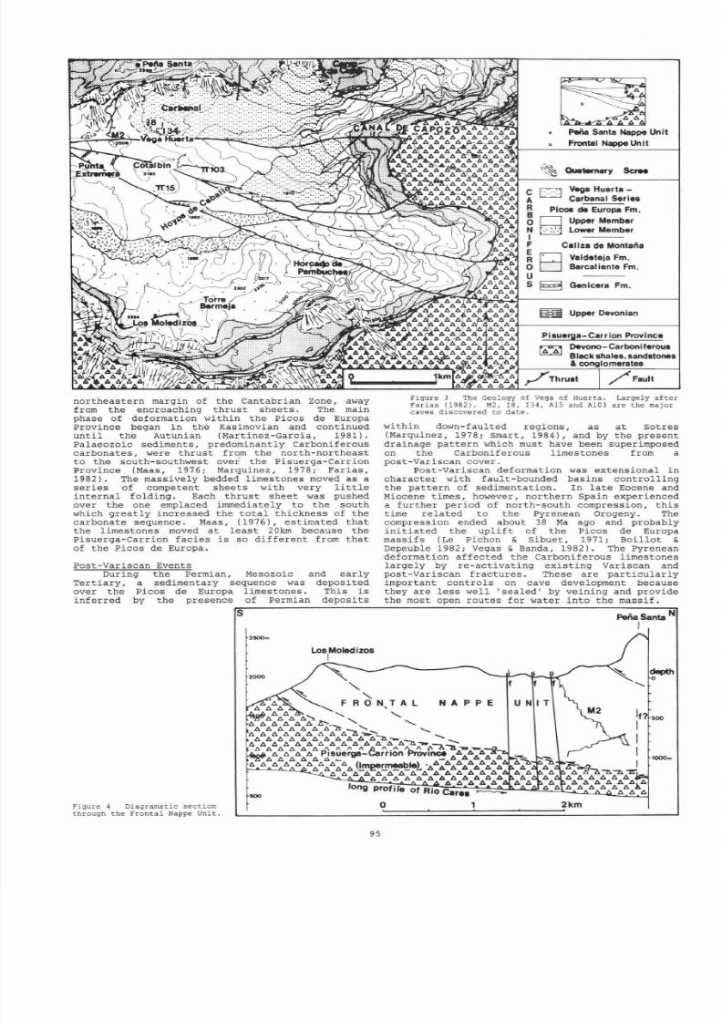
Figure ) The Geology of Vega of Huerta .
Largely
a f t e r
Farias
1982).
M2 I8 , I 34, A15 and A10) are the major
caves
discovered
to date
within down-faulted regions, as
a t
Sot res
Marquinez, 1978; Smart, 1984), and
by
the present
drainage
pat te rn
which
must
have
been superimposed
on
the Carboniferous l imestones
from a
post -
V
ar i scan cover.
Post -Var iscan deformation
was
extensional
in
charac te r with fault-bounded basins
cont ro l l ing
the pat te rn of sedimentat ion. In l a te Eocene and
Miocene t imes,
however,
nor thern
Spain experienced
a fur ther per iod
of north-south compression, t h i s
t ime
re la ted
to
the Pyrenean Orogeny. The
compression ended about 38
Ma
ago
and
probably
in i t i a ted the upl i f t of the picos de Europa
massi fs
Le Pichon Sibuet , 1971; Boi l lo t
Depeuble 1982;
Vegas
Banda, 1982). The Pyrenean
deformation
af fec ted
the Carboniferous
l imestones
l a rge ly by re -ac t iva t ing exi s t ing
Variscan
and
post -Variscan f rac tures . These are
par t i cu la r ly
important cont ro ls on cave development
because
they
are
l ess
well
sea led
by veining
and
provide
the most open routes for
water in to
the
massif .
N P P E
Perla
Santa N
I
depth
o
500
l000m
Figure 4 Diagramatic sect ion
through
the
Fronta l Nappe Unit .
o
2km
,
95

8/21/2019 BCRA 14-3-1987
http://slidepdf.com/reader/full/bcra-14-3-1987 8/52
The
Geology of
Vega Huerta
The Western Massif has been mapped
by Far ias
(1982) al though only the
eastern
par t
of
the
range
i s
covered (Figs. 3 and 4) . Far ias
ident i f ied
four
major Variscan t h ru s t
sheets (or
nappes).
Each i s over thrus t
on
to the
one immediately
to
the south
so t ha t
the dip of the th rus t s genera l ly
increases
from south
to north. Vega
Huerta
i s
located on the
f i r s t
(most southerly) nappe to be
emplaced which i s
ca l led the
Frontal
Nappe
Unit.
The
highest mountain
in the
massif , Pena Santa, i s
located
a t
the
f ront
of
the
second nappe,
the
Pena
Santa Nappe
Unit .
Within
the Frontal Nappe Unit
the dips
of
the beds
i s
genera l ly 0° to 20°
al though
the
dip reaches 30° a t
the
southern
escarpment
and s teeper dips
occur
near major
fau l t s .
This cont ras t s with the area to the
nor th
and around
Treviso
where the dip
is
ra re ly less
than
45°.
All the l imestones of
the
Frontal
Nappe Unit
are
potent ia l ly cavernous
al though the
Vega
Huerta-Carbanal Ser ies which has a
s igni f icant
shale content , contains only collapsed shaf t s a t
the
surface with
no negotiable entrances
found to
date .
Erosion
of
t h i s formation has produced
windows
in to
the under lying Picos de Europa
Limestone
Formation
within which the
caves
I8 and
I34 are
developed (Fig. 3).
Several
major post -Var iscan
fau l t s
cut
the
Fronta l
Nappe
Unit.
These
t rend east-west
and
southeast-northwest and three come together j u s t
to the
south of
the
entrance of
M2 There are
also
many
l e s s per s i s t en t
f rac tures , not
shown
in
Fig.
3, but
which are
clear ly
important cont ro ls
on cave development.
CAVE
DEVELOPMENT
WITH SPECIAL
REFERENCE
TO
M2
The
Frontal
Nappe Unit d i f fe r s
from
the
nappes emplaced
l a te r
in
the region north of Pena
Santa)
in
tha t the l imestones r es t on the rocks
of
the
Pisuerga-Carr ion
Province.
These
are l a rge ly
black
shales ,
sandstones
and conglomerates and
therefore
provide
an
impermeable
basement
to the
l imestones. The Rio Cares
has
cut complete ly
through the Frontal
Nappe
and now f lows some 300
metres below the base of the
l imestones.
Therefore
vadose
condit ions
must have
exis ted
throughout
the Frontal
Nappe
for a
considerable
per iod
(Fig. 4). At the presen t t ime, water
draining to the base
of
the Frontal Nappe can be
96
expected to flow down the dip of the basal
th rust ,
approximately towards 010°. In par t of the area
explored
by
OUCC between Pefia Santa and Ar io,
there appears to
be
be a perched water
- tab le
which
causes the caves
to
terminate in sumps
a t
an
a l t i t ude
of
about
1300 metres (Roberts,
1986).
The
existence
of
the
M2
cave system, which
descends almost
to the
base
of
the
l imestones,
demonstrate the absence
of
a water
- tab le
a t 1300
metres in the
Frontal Nappe.
As
Smart (1984) commented, cave development
would
have
been
in i t i a ted
with
the
exposure of
the
Carboniferous
l imestones from
beneath the
post -Var iscan
sedimentary
cover .
At
present there
i s l i t t l e informat ion to date
t h i s
event but
erosion of the post -Var iscan
cover
would have both
accompanied and
followed
the
up l i f t
of the Picos
de
Europa. Major cave systems probably developed
while the
post -Var iscan
cover
supported large
drainage
catchments
and concentrated water in to a
few
s inks .
Such
systems
wil l
be termed
cover
systems in t h i s paper. As the cover was eroded
however,
an
inc reas ing
number
of
smaller
catchments
would have
developed as
new
f rac tures
were exploi ted. Many of the exis t ing sinks and
cave passages
would
have been
abandoned.
The glac ia t ion
of the
Picos de Europa
dur ing
the Quaternary
had a
number of
important
af fec t s .
Glacial per iods are charac ter i sed by both erosion
and
deposi t ion
so
many
establ ished
depressions
were undoubtedly choked with
debris .
However,
cave systems were probably formed a t t h i s new time
by
g lac i a l meltwater
sinking
in to
the l imestones
as
proposed
by Smart (1986) fo r many
caves in
the
Eastern Massif. Essent ia l ly the glac ie r s provided
large
catchments
and concentrated water in to
cer ta in s inks . The Picos
de
Europa must have been
a region of
high re l i e f
before
the Quaternary
glac ia t ions ,
so the
majori ty of the post -Var iscan
cover
may have
been
eroded (and major
caves
developed)
before
the onset
of
glacial
condi t ions .
Since the r e t r ea t
of
the glac ie r s the
surface
of the Frontal
Nappe has probably changed
very
l i t t l e
except
that
most of
the larger shaf t s
have
gradual ly choked with scree . At present there are
hundreds of
shaf t s developed in
the surface of the
Frontal Nappe but very few lead to negotiable cave
passages.
The
l a rge
number
of
f rac tures
means
that
each one has only a
small catchment
area,
of ten receiving water only from the
snow-plug
within i t . These f lows are
insuff ic ien t
to keep
T
op camp below
the sou th
face of
Pena Santa The main face
i s
composed
of l im s ton s from
the
Barcaliente
Formation which are
th ru s t over the
disrupted Vega
Huerta
Carbanal Series
8/21/2019 BCRA 14-3-1987
http://slidepdf.com/reader/full/bcra-14-3-1987 9/52
cave passages
c lear
of
the debr i s
loosened
by
f reeze- thaw ac t ion in the winter months. The
ent r ances
to
the
cove r sys t ems are almost
cer ta in ly eroded
or
buried, al though deeper
passages may have been
preserved.
The
maj
or cave
systems
discovered to date
are
usua l ly those
with
entrance
passages which
ha ve be en crea ted
or
enlarged by
me
l twater and wh ich have then escaped
i n f i l l bec
ause
of a f o r tunate loca t ion or because
t hey have high- leve l
routes
over the blockages
crea ted by debr i s from the
surface Laverty
and
Senior ,
1981).
THE M2 CAVE
SYSTEM
The
entrance of M2 i s located about 400
metres
west o f
Vega
Huerta beneath
the
imposing
south face of Pena Santa . In th i s loca t ion ice
accumulati on was probably le ss extensive
and
le ss
prolonged
th an on the
nor th- fac ing
slopes
of
the
areas explored by aucc and LUSS. Never theless,
remnants of terminal mor
a ines
ex i s t in the major
depressions
south of Pena Santa
and
glacia l
rounding is
evi
d ent
in the
l imestone
r idge
conta in ing the entrance
of M2 The
entrance
is
on
a minor
fau l t
dipping
65°
to 020° which forms a
l i n e a r
depression
along
t he long axis of
the
r idge
. A poss ib le explana t ion f o r t h i s loca t ion
i s that crevassing
occurred where the
ice rode
over the r idge
so
that
supra-g lac ia l
and
en-g lac ia l meltwater was direc ted to the base of
the
glacier , where t then sank i n to
the
M2 cave.
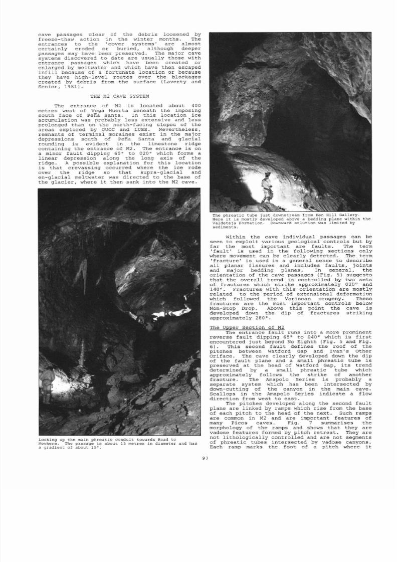
Looking
up
the
main
phreat ic
conduit
tow ards Road
to
Nowhere The passage s
about
15
metres
n
diameter
and has
a gradient
of
about 15 .
97
The phreat ic tube jus t downstream from Ken Hil l Gallery.
Here t is mostly developed above a bedding plane
within the
Valdeteja Formation ownward solut ion was
l imited
y
sediments
Wi th in
the cave ind iv idua l passages
can
be
seen
to explo i t var ious geological cont ro ls but by
fa r
the
most important are f au l t s . The term
f a u l t i s used in the fo l lowing sec t ions only
where movement
can
be
c le a r ly
detec ted .
The
term
f r ac tu re
i s
used
in
a general sense to describe
a l l planar f is sures
and
includes f au l t s ,
jo in ts
and
maj
or
bedding
planes. In
general ,
the
orien ta t ion
of the
cave passages
Fig.
5)
suggests
that
the
overa l l t rend
i s cont ro l led by
two se t s
of
f rac tures
which
s t r i k e approximately 020°
and
140°. Fractures with th i s o r ie n ta t io n are mostly
re la ted
to the per iod
of extensional deformation
which
followed
the
Variscan
orogeny.
These
f rac tures are
the most
important
cont ro ls
below
Non- Stop Drop.
Above t h i s
point the
cave i s
developed down
the dip
of f rac tures s t r ik ing
approximately 280°.
The
Upper Sect ion of M2
The
entrance
f au l t runs
in to
a more prominent
reverse
fau l t
dipping
65°
to
040° which i s f i r s t
encountered
j u s t
beyond
No
Eighth Fig .
5
and
Fig.
6).
This second fau l t
def ines the roof of the
pi tches between Watford Gap
and
Ivan s
Other
ar i face .
The
cave c le a r ly developed down
the
dip
of
the
fau l t plane
and
a small
phrea t ic
tube i s
preserved
a t the head
of Watford Gap, i t s t rend
determined
by
a small
phrea t ic
tube which
approximately follows
the
s t r i k e of
another
f rac ture . The
Amapolo Series
i s probably
a
separate system which has been in te rsec ted by
down-cutting
of the
canyon in the
main
cave.
Scal lops
in
the
Amapolo Series ind ica te a flow
direc t ion f r om we
s t
to eas t .
The
pi tches developed along the second
fau l t
plane
are l inked
by ramps
which
r i se
from the base
of each pi tch to the head of the next . Such ramps
are corrunon in M2 and are important fea tures of
many Picos
caves.
Fig . 7
surrunarises the
morphology of the ramps and
shows that
they are
vadose fea tures formed by
pi tch
re t rea t . They are
not
l i tho log ical ly
cont ro l led
and
are not segments
of phrea t ic
tubes in te rsec ted by vadose canyons.
Each
ramp
marks the foot
of
a
pi tch
where t

8/21/2019 BCRA 14-3-1987
http://slidepdf.com/reader/full/bcra-14-3-1987 10/52
\C
co
~
~ n t r a n
P2
~
::
..
r ~ · . · ·
Amapolo
Ser
ies
IP49
o
100
Ivan s Other
Orj
fice
200
Play the White
Man
300
~ ~ W e t a m p
p ~ V Y · R a m p
EXTENDED
EL
N
\Non-Stoporo
p
EVATION
o
50
100
200
metres
YUCPC SEll
1987
8CRA
58
Location
; . o
S8 W ,43°12 N
I
t i
tude
:
1980
metres
Vega
Huerta
Picos de
Europa
N. Spain
600
700
800
900
ooo
Entrance
Sump
.
o
50 100
200
M2
metres
POl Ode Cuetalbo)
650
c:d-
EI Gordo
P12
Highway Star
P34
Pitch
CROSS-SECTIONS 2 XMAIN SCALE
t 8 ~ t
• I. •
b e
e
f 9
cJ
iJ
[:Ii
k I
m
Choke
823
Figure
5 1987
Survey
of
M2
Multiple phreat ic
levels near
Ken
Hi l l
Gallery have been omitted for
c la r i ty
8/21/2019 BCRA 14-3-1987
http://slidepdf.com/reader/full/bcra-14-3-1987 11/52
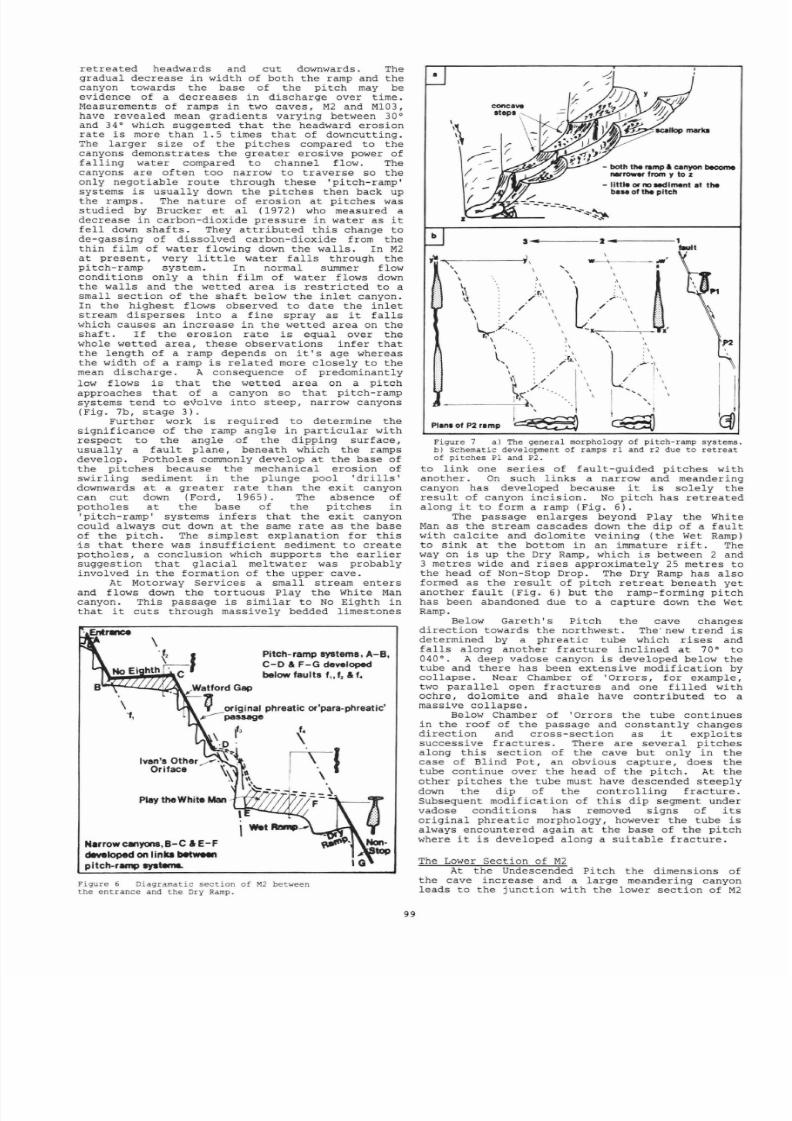
re t rea ted headwards and cut downwards.
The
gradual decrease
in width
of both the ramp and the
canyon towards the base of the pi tch
may
be
evidence
of a decreases
in
discharge
over t ime
.
Measurements
of ramps
in two
caves,
M2 and Ml03,
have
revealed
mean gradients varying
between
30 °
and 34°
which suggested
that
the headward erosion
ra te i s more than 1.5
times t ha t
of
downcutting.
The larger
s ize of the pi tches compared to the
canyons demonstra tes the grea te r eros ive power of
fal l ing water compared
to
channel f low. The
canyons
are
of ten
too
narrow
to
t raverse
so
the
only negotiable route
through
these pi tch-ramp
systems
i s
usual ly
down
the pi tches then back
up
the ramps. The nature of erosion a t pi tches was
studied by Brucker
e t a l (1972)
who
measured
a
decrease in carbon-dioxide pressure
in water
as
it
fe l l down shaf t s . They
at t r ibu ted
th i s change to
de-gassing of
dissolved carbon-dioxide from the
th in
f i lm of
water flowing
down
the wal ls .
In
M2
a t
present , very
l i t t l e water fa l l s through the
pitch-ramp system .
In
normal summer
flow
condit ions only a th in
f i lm of
water flows down
the wal ls
and the wetted area
i s
r es t r ic ted to
a
small
sec t ion of
the shaf t below the i n l e t canyon.
In the highest flows
observed
to date the i n l e t
stream
disperses
into
a f ine spray as
it fa l l s
which causes an increase in the wetted ar ea on the
shaf t . I f the erosion ra te
i s
equal over the
whole
wetted
area ,
these observat ions
in fer that
the length of a
ramp depends
on
it s
age
whereas
the width of a ramp i s re la ted more
closely
to the
mean
discharge.
A
consequence
of
predominantly
low f lows
i s
t ha t
the wetted area on
a
pi tch
approaches t ha t of
a canyon
so that
pitch-ramp
systems tend to
evolve in to
s teep ,
narrow
canyons
(Fig
.
7b,
stage 3) .
Further work
i s
required to determine
the
signif icance
of
the ramp angle in par t i cu la r with
respect to
the angle
.of the dipping sur face ,
usual ly a
f au l t
plane, beneath which the ramps
develop. Potholes
commonly develop
a t the
base
of
the pi tches
because
the mechanical erosion of
swir l ing
sediment in the
plunge
pool d r i l l s
downwards a t
a
greater
ra te than
the ex i t
canyon
can
cut down (Ford,
1965). The
absence of
potholes
a t
the
base
of the pi tches in
pi tch
-ramp
systems
in fe rs
t ha t
the
ex i t
canyon
could always
cut down a t the
same
ra te
as the base
of
the
pi tch . The
simplest
explanat ion for t h i s
i s t ha t
there was
insuff ic ien t sediment
to
create
potholes , a conclusion which
suppor ts
the ear l ie r
suggest ion
that g lacial meltwater was probably
involved in the formation
of
the upper cave.
At
Motorway Services a small s tream enters
and f lows down the tor tuous Play the White Man
canyon. This passage
i s
similar to No Eighth
in
that
it
cu ts
through massively
bedded
l imestones
\
Pitch-ramp systems,
A-B,
C-O
F-G
developed
below faults
f
f
f .
- - - . r - . . . . - - - l . ~ , W a t f o r d
Gap
i original phreatiC or para-phreatic
p s s g e
f,
N.rrowcanyons,B-C
IE F
developed
on
I
nks
betwe.'I
pitch-remp
8yStMnL
,
Figure 6 Diag ramati c
se t i on o f
M between
the entrance and the
Dry Ramp.
99
a
concave
steps
/
b
---a .. - - - - - - -
,
,
\
Plana of P2 ramp
,
w -
,
,
Figure 7 a) The
general
morphology
of pitch-ramp
sy
stems.
b)
Sc hem
at i c development of ramps r l
and
r2 due
to
retreat
of pi tc hes
Pl and
P2
.
to l ink
one
ser ies of
fau l t -gu ided
pi tches with
another .
On such
l inks a
narrow and meandering
canyon
has
developed
because it
i s
so le ly
the
r esu l t
of canyon
incis ion.
No
pi tch has
re t rea ted
along
it to form
a
ramp (Fig. 6).
The
passage
enlarges
beyond
Play
the
White
Man as
the stream cascades
down
the dip
of a
f au l t
wi th
ca lc i t e
and
dolomite
veining ( the Wet Ramp)
to
sink
a t the
bottom in
an immature r i f t .
The
way on
i s
up the Dry Ramp, which
i s
between
2 and
3
metres wide and r i ses approximately
25
metres
to
the head of Non-Stop Drop.
The
Dry Ramp has also
formed
as
the
r esu l t
of
pi tch
r e t r ea t beneath yet
ano t her
fau l t
(Fig.
6)
but the ramp-forming pi tch
has been abandoned due to
a
capture
down the Wet
Ramp.
Below
Gareth s pi tch
the
cave changes
di rec t ion towards the northwest.
The
· new t rend i s
determined by a phrea t ic tube which r i ses and
f a l l s along another
f racture
inc l ined a t 70° to
040°.
A
deep vado
se canyon i s developed
below the
tube and
there
has been extensive modif icat ion
by
col lapse . Near
Chamber
of Orrors ,
for example,
two para l l e l
open
f ractures
and one
f i l l e d
with
ochre,
dolomite
and shale have contr ibuted to a
massive col lapse .
Below
Chamber
of Orrors the tube
cont inues
in the roof
of the passage and cons tant ly changes
di rec t ion and
cross
-s
ect ion
as it explo i t s
successi ve
f rac tures . There
are severa l p i tches
along
t h i s sec t ion of the
cave
but
only in the
case of Blind Pot , an obvious capture, does the
tube cont inue
over
the head of the pi tch .
At
the
other pi tches
the tube
must
have descended steeply
down the dip of the
control l ing
f rac ture .
Subsequent modificat ion of t h i s dip segment
under
vadose
condit ions has
removed
signs of
i t s
or ig ina l phrea t ic morphology, however
the tube
i s
always encountered again
a t
the base of the
pi tch
where
it
i s
developed
along
a
su i tab le f rac ture .
The Lower
Sect ion of
M2
At
the
Undescende
d Pitch the dimensions of
the
ca
ve
increase and
a
large meandering canyon
leads
to
the
junct ion with
the
lower sec t ion
of
M2

8/21/2019 BCRA 14-3-1987
http://slidepdf.com/reader/full/bcra-14-3-1987 12/52
a t Ken Hil l Gallery.
Remains
of phrea t ic tubes
more than 3 metres in diameter
revea l
the or ig in
o f
t h i s
sec t ion of
the cave
although there has
been
subs tant ia l modificat ion by col lapse . Two
major
phrea t ic
condui ts
meet a t Ken Hil l Gallery.
One
is the
Tea-Time
Ser ies
which has
suf fe red
two
captures , one
wi th in
Ken
Hi l l
Gallery
where the
Tea-Time Ser ies
enters
and another
a t the l imi t
of
'upstream' explora t ion . These two routes
join
and
then choke a t 823
metres.
The second major
phrea t ic
i n l e t
l i e s
in
the
roof of
the
canyon
between
The
Undescended Pi tch and Ken Hil l
Gallery. Near the bottom of Ken Hil l Gallery,
below the camp, a s tream jo ins the main gal le ry ,
f lowing
in
a meandering canyon. A small
phrea t ic
tube
in the roof
diverges
from
the
canyon
in an
upstream di rec t ion and terminates a t a pai r of
perched
sumps. In a downstream di rec t ion from Ken
Hil l Gallery, inc i s ion
by
the i n l e t s tream
gradual ly increases and eventual ly the l a rge
phrea t ic
passage in the
roof becomes
inaccessible .
The
s tream fa l l s down some wet pi tches (another
r e l a t ive ly recent
capture)
and eventual ly
disappears in to
Nicky's
Rif t .
Fortunately the
phreat ic passage can be
regained
above the Road to
Nowhere
af te r which it again
descends, clear ly
developed
down the
dip
near
and
a t
the base
of
the
Valdet
e ja
Forma t ion (Fig. 8) . The main phrea t ic
condui t
explo i t s both
fau l t s
and bedding
planes
but
it s
general t rend
seems to
be
cont ro l led by
the
bedding
of the massive Va lde te ja Formation.
In Ken Hil l Gallery and adjoining passages
there are considerable thicknesses of sediments
which
are
of
f ive
main types:
1. Unsorted,
l imestone boulder beds with
rounded
boulders up to 0.7 metres in length. These make
up the
largest
volume
of sediment.
2. Well
sorted,
well
rounded,
imbr icated
l imestone
pebble beds
.
3. Cross- laminated and cross bedded
sands
and
s i l t s
of
many colours with lenses
of unsor ted
sandy
gravels , the
mater ia l
loosely
termed g r i t
in
Fig. 9.
4. Well rounded, brown to red, gravels and sandy
gravels . These are an equivalent l i thology to the
lenses
of unsor ted,
sandy
gravel
( g r i t ) within
the cross bedded
sequence,
however they have a
much wider
dis t r ibu t ion .
5. Dark
brown
clay.
This i s found on top of the
cross-bedded sequence
and
i s
the
mater ia l
f i l l i ng
the f i s sure
in
Fig. 9.
Figure 9 Sketch of the sediments below the
climb to the Tea-Time Ser ies .
S
?
.
\
\
\
\
\
N
Figure 8
The
r e la t io n sh ip of
the ma
i n
phre a t i c condui t
t o
the
geology near Last Big Chamber showing how the chamber
develo ped
by
so lu tion a t the bottom o f a phre a t i c
lift.
The sandy
gravels
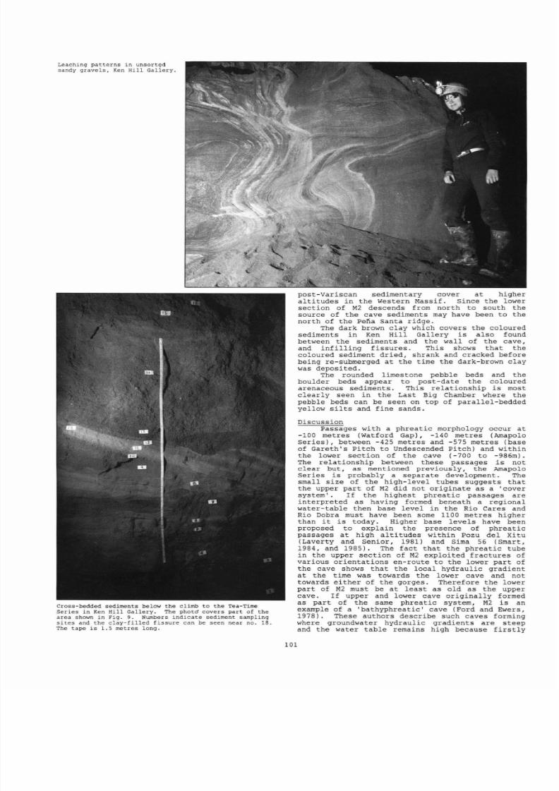
are remarkable sediments.
They are extremely porous and water moving
through
the deposi ts
has
produced spec tacu la r
leaching
pat te rns . Some beds are weakly cemented by
ca lc i t e
but most are unconsol idated and form
extensive ta lus
slopes
in
Ken Hil l Gallery.
The
cros s-b edded sequence of
s i l t s , sands
and
sandy-gravels appears to be the oldest
sediment
preserved and
represen ts
a l te rna t ing still and
energet ic periods.
Most
of
the
f ine
material ,
par t icu lar ly the
blue-grey s i l t , i s found a t
the
bottom
of the
sequence. The
sandy gravels are
found cut t ing across the beds beneath and become
more extensive towards the top
of
the sequence.
One lens
has clear ly been deposi ted in
a
channel
with a s teep bank showing
t ha t
the
phreat ic
condui t
was
a t l e s t
par t ly
drained
when
the l a s t
of the
coloured sediments were being deposi ted.
The
unsor ted
nature
of
the sandy
gravels and
the
chaotic inc lus ion of s i l t
i n t r ac l as t s
suggested
that
these mater ia l s were deposi ted
suddenly
a t
the
confluence of a
fas t - f lowing i n l e t
( the
Tea-Time Series?) with a r e l a t ive ly still
r iver
o r
lake
within
Ken
Hil l Gallery.
The Carboniferous succession
in
the Picos de
Cornion
(Fig. 2) contains no formation which could
have provided these
materials .
They are most
s imi lar to
the
so-cal led
'Red
Permian'
formations
l ike the Sotres Formation of the
Eastern Massif
(Marquines,
1978,
Martinez -Garc
i a , 1981, Smart,
1984) or the Labra Formation (Maas, 1976). In the
western Massif , a small
outcrop of
'Red Permian'
i s preserved
to
the
north
of
a mountain ca l led
Valdepino, about km west
of
Vegabano,
but
a t
an
a l t i t ude
of only 1400 metres.
The M
cave
sediments
provide the f i r s t d i rec t evidence of a
fissure
f i l led with
brown
alit
pale yellow laminated sands with
orange
silt
lam inae
ark brown yellow grit
coarse, red laminated sands red silt
pale brown y e l ~ o w ~ s ~ ~ n d ~
~ ~ ~ ~ ~ ~ ~ ~
~ ~ ~ i j ; I I I B l l i l l ~ ~ ~
ellow sil t
I
gM
brown sand
grey grit
cross- laminated red , U ' ~ _ _ ,--
coar grit
wit
leaching patterns
red sand
yellow sand
_
r t
fine
yellow sand brown
grit
2
o
metr
yellow sand
silt = = = = = ~ ~ ~ ~ i i ~ I I I ~ ~ I ~ i i ; ~ i ~ i ~ ~ ~ ~ ~ ~
oarse brown sand _ _ cross laminated. red
aand
laminated yellow brown silt - - -
.
__ fine red sand
pale
blue
-g rey silt
with some
~ ~ ~
. : .
brown laminae - :::::--:...: :
brown grit
load structures
100
8/21/2019 BCRA 14-3-1987
http://slidepdf.com/reader/full/bcra-14-3-1987 13/52
Leaching
patterns in u n s o r t ~
sa n
dy gravel
s , Ken
Hill Gallery.
Cross-bedded
sediments
below
the
climb
to the
Tea-Time
Series
in Ken Hill Gallery. The
photd
covers par t of the
area
shown in
Fig.
9. Numbers indicate se d iment sampling
s i t e s and
the c l a y f i l l e d f i s su r can be
seen near
no 18
The
tape
i s
1.5 metr
e s long.
101
post -Var iscan
sedimentary cover
a l t i t udes
in
the Western
Massif.
Since the lower
sec t ion
of
M descends from nor th to south the
source
of
the
cave sediments
may
have
been
to the
nor th
of
the
Pena Santa r idge.
The dark brown clay which covers
the
coloured
sediments
in
Ken Hil l Gallery i s
also
found
between the
sediments
and the wal l
of
the
cave,
and
i n f i l l i ng f i s sures .
This
shows tha t
the
coloured
sediment dr ied ,
shrank
and
cracked
before
being
re-submerged
a t
the
t ime
the
dark-brown
clay
was deposi ted.
The
rounded l imestone
pebble
beds and
the
boulder beds
appear
to pos t -da te the coloured
arenaceous sedimen ts. This re la t ionship i s most
c lear ly
seen in the
Last Big
Chamber
where the
pebble
beds can
be
seen
on top of paral lel-bedded
yellow s i l t s and f ine sands.
Discussion
Passages with a phrea t ic morphology
occur
a t
-100
metres
(Watford Gap), -140 metres
(Amapolo
Ser ies ) ,
between -425
metres and
-575
metres (base
of
Gareth s pi tch
to Undescended Pi tch) and
within
the lower sec t ion of
the
cave (-700 to
-986m
) .
The re la t ionship
between these
passages i s not
c lear but, as mentioned previously,
the
Amapolo
Series
i s
probably
a separa te
development. The
small
s ize
of the
high- level
tubes suggests
t ha t
the
upper par t
of M did
not
or ig ina te
as
a cover
system I f the
highest
phrea t ic
passages are
in te rpre ted as having
formed
beneath
a
regional
water - table then
base
l eve l in the Rio
Cares
and
Rio
Dobra
must
have been
some
1100 metres higher
than
t is
today.
Higher
base l eve l s have been
proposed to explain
the
presence
of phrea t ic
passages a t high a l t
udes
wi th in
Pozu del
Xi tu
(Laverty
and Senior , 1981) and
Sima
56 (Smart,
1984, and 1985).
The
fac t tha t
the
phrea t ic tube
in
the
upper sec t ion of M
exploi t ed
f ractures
of
var ious
or ienta t ions
en- route to the
lower par t of
the
cave shows tha t
the
loca l
hydraul ic
gradient
a t
the
t ime was towards
the
lower cave
and
not
towards e i ther
of the
gorges. Therefore
the
lower
par t of M must be a t
l eas t
as
old
as
the upper
cave.
I f
upper
and
lower
cave
or i g i na l l y formed
as
par t
of the
same
phrea t ic
system,
M
i s an
example of a bathyphrea t ic
cave (Ford
and Ewers,
1978). These authors
descr ibe
such
caves
forming
where
groundwater
hydraul ic
gradients are s teep
and the
water t ab le remains high because
f i r s t l y
8/21/2019 BCRA 14-3-1987
http://slidepdf.com/reader/full/bcra-14-3-1987 14/52
the
f i s sure
network
is immature
and secondly
the
dis tance
between
point of
inf lux and the
resurgence i s grea t .
This in terpretat ion
impl ies
that
the
main phreat ic tube in the lower cave must
r i se
again,
perhaps
by
as much as 500
metres,
to
it s
former
resurgence
l eve l
. According to
the
model of
Ford
and Ewers
(1978)
bathyphreat ic
caves
evolve
towards deep-phrea t ic then water - tab le
caves as the f i s sure network matures and
shorter
routes
are exploi ted
between the
point of inf lux
and
the
resurgence.
Such
passages are not seen
in
the upper par t
of
M2 and the
single
phrea t ic tube
which cont ro ls the t rend
of
the upper cave shows
no s igni f icant
inc rease in
s ize
with depth. These
observat ions suggest
that phreat ic
condit ions
exis ted for about the
same
length
of
t ime
throughout the whole
of
the upper cave. The upper
cave
was
poss ib ly
abandoned a t an ear ly stage then
re -ac t iva ted some t ime l a te r under
vadose
condi t ions .
However, the
e a r l i e s t
vadose canyon in the
upper cave
i s
everywhere developed below the small
phreat ic tube. I t has not
explo i ted o ther rou tes
so the period of abandonment was
not
long enough
to al low a
s igni f icant
increase in the
permeabi l i
ty
of
the f i s sure network
by
the t ime
vadose condit ions become establ ished. Within the
bathyphreat ic model, a very rapid drop
in base
level
seems
to
be
required
to
explain these
observat ions.
The phrea t ic morphology
of
the
e a r l i e s t
passage in the upper sec t ion
of
M2 may, however,
be
an
extreme example of a
para-phrea t i c passage
(Tratman, 1957).
A para-phrea t ic
passage
i s one
formed where l a rge volumes of water dra in through
a network
of
low permeabil i ty f i s sures within the
vadose zone. Local
phrea t ic
condit ions would
have
exis ted as
long
as
the
volume of
water
exceeded
the capac i ty
of
the passage.
I f
an immature
f i s sure network i s assumed, such condit ions may
have
exis ted
long
enough for phreat ic
tubes to
have formed on the more hor izonta l sec t ions of the
immature cave. Vadose condit ions would have
become es tabl i shed
f i r s t
on the more ver t i ca l
segments where
capac i ty to t ransmit
water was
grea te r . This
model i s proposed
because
it would
explain the
morphology
of the
phrea t ic
passage
in
the upper cave without invoking a sudden
drop
in
base l eve l . The regional water t ab le could
have
been
f a i r ly
s tab le , probably close
to
the level
of
Ken Hil l Gallery, a t the t ime the upper cave
was
in i t i a ted .
Both models require an immature f i s sure
network but the condit ions in the
aqui fer
are
Feldspathic conglomerates of the
Red
Permian north of
Valdepino.
Rocks
l ike
these
are
the l ike ly source for the
coloured
sediments
in M2
qui te d i f fe ren t ,
phrea t ic
in the
case of the
bathyphreat ic model
and vadose in the
para-phrea t ic model. At present there
is
insuff ic ien t
evidence to prove
or
disprove e i ther
of
these in terpretat ions .
Further explora t ion may
show
whether the phrea t ic r i se r
in fe r red
by the
bathyphrea t ic model ac tua l ly
ex i s t s .
The lower sec t ion
of
M2 was c lear ly a major
phrea t ic
condui t
and acted as the focus for
severa l subter ranean st reams.
The
large
passages
and
sediments
in
the
lower cave
may
be
remnants
of
a pre-g lac ia l cover -sys tem , formed wi th in the
phrea t ic
zone, and
explo i ted by
caves
in i t i a ted
under
g lac i a l
condit ions.
Torca de Urr ie l lo in
the Central Massif appears to be
similar
to M
although the author has no personal exper ience
of
the cave. From
the publ ished
survey,
the
upper
sec t ion of
Torca
de
Urr ie l lo
has
developed
down
the general dip of the beds and major s t ruc tures .
This sec t ion
of
cave l inks in to a much l a rger , and
probably much
older
development or iented along
the
s t r ike .
I t may not be coincidence
that the lower
sec t ions of M2 and Torca de Urr ie l lo are both
a t
s imi lar
a l t i t udes .
102
The
t rend of the
lower passages in M2 gives
no
clue to
the
loca t ion of the ancient
r i v e r s
resurgence
but
presumably
it
was
in
the Rio Cares
or
Rio
Dobra. The s tream which enters the
lower
cave
a t
the
bottom
of
Ken
Hil l
Gallery s inks
in to
Nicky s Rif t and f luoresce in dye has proved
t ha t
the
same water
emerges
again near the terminal
sump . From there
the
water has
been
t raced to
the
canal
de
Capozo some
4km
to the
eas t
and
approximately 350 metres lower than the terminal
sump (Lloyd,
pers . comm.).
The major
east-west
fau l t located j u s t
to
the
south
of M2 probably
conducts
the
water to t h i s
resurgence and may
prove to
be
a
key
fea ture
cont ro l l ing
the t rend of
the unexplored continuat ion
of
the main
phreat ic
passage.
Fur ther explorat ion i s
required to
determine the des t ina t ion
of
the
ancient
r iver
which formed the main
phreat ic
condui t .
The geological
sec t ion
through the
Frontal
Nappe (Fig. 4) shows t ha t perhaps 300 metres
of
limestone
may
ex i s t beneath the
sump
a t
-986
metres.
This in terpretat ion
i s
based on the fac t
that
the top of the
Barca l ien te
Formation
i s
seen
within the cave a t an a l t i t ude of about 1100
metres (-900 metres depth) while along the s t r ike
to
the east , in the Canal
de Capozo,
the
Barcal iente Formation reaches 400 metres
in
thickness
because
of
over thrus t ing (Fig. 3).
The
dip of the Barcal iente Formation in the lower
passages
i s
about 5°
to
the
south and it i s
probable
that
the
same
r es i s tan t
l eve l
i s
responsible for the terminat ion
of
the cave a t the
-823
metre
choke, in Nicky s Rif t and a t the f ina l
sump.
CONCLUSIONS
The
discussion
above
and
the
conclusions
summarised below are
based
on observat ions made
dur ing the 1986 and 1987 expedit ions to M2. I t i s
hoped
that
sediment analyses
wi l l
be completed
dur ing 1988 which wil l ident i fy the source rocks
with more
cer tain ty
and poss ib ly provide a da ta
for
the
depos i t s .
The prel iminary
conclusions
are:
1.
The
geology of the Frontal Nappe Unit provides
dif feren t condit ions for cave development compared
to
the
o ther
nappes because the
l imestones have an
impermeable basement.
2. The
ramps
found in
M2
and many
other picos
caves are vadose fea tures formed
by
pi tch- r e t r ea t .
Ramps form where sediment supply i s low which
prevents
potholing a t the base
of
the
pi tches.
Glacial meltwater i s proposed as the l i ke ly agent
responsible for
the
erosion of the pi tch-ramp
sec t ions .
3. The phrea t ic tube in the upper par t
of
M2
exploi ted various,
low permeabil i ty f i s sures to
t ransfer water
down the
loca l hydraul ic
grad ien t
into
the
lower
sec t ion of the cave. I f the upper
cave or ig ina tea beneath the regional water t ab le
the
whole
of
M2
i s an example of a bathyphreat ic
cave. The
phreat ic
tube in the upper cave may,

8/21/2019 BCRA 14-3-1987
http://slidepdf.com/reader/full/bcra-14-3-1987 15/52
The Last
Big Chamber.
The th in
beds
vi s ib le i n the far wal l
are
within the top p ar t of the
Barca
l
i ente Formation.
however , be a para - phrea t ic pa s sage fo r
me
d within
an
extens ive
vadose zone .
4 . T
he
lower sec t ion of M2 acted as a maj
or
phrea t ic
condu i t
an
d formed
before post
- Variscan
sed ime n
t s
w
er
e c omp l e te
ly
e r oded from
th
e
Ca rbon i f erous m
es tones
.
5.
The sedimen t s in Ke n Hil l Ga l l e ry
are
probably
der ived f r om Red P
erm
i an
fo
r m
a t i
ons now erode d
f rom most o f the Western Ma s
s i f .
ACKNOWLEDGEMENTS
I would
l i ke
to
thank the members of York
Universi ty
Cave and Pothole
Club and
the
Seccin de
Espeleologia
Ingenieros
Indus t r i a l e s who ca r r i ed
out the explora t ion
and
survey of the M2 cave system. Without t he i r s k i l l
t h i s
paper
could
not
have
been wr i t ten . Specia l thanks are due to a l l
those who helped with photography or car r ied sediment and
rock samples from the cave, to
Andy
Kemp for t h i s help in
surveying
ramps, to Katherine Force and Ivan Walton for
ass is tance
with
the sampling and photography
of
the
sediments
and
to
Enrique
Vulture Fdez.
Giber t
who shares
my
cur ios i ty and obtained useful maps and
air-photographs .
The
expedi t ion
could
not
have
taken
place
without the generous
suppor t from the
many
sponsors l i s t e d
below
and I am
par t i cu la r ly gra t e fu l to the Royal Geographical Socie ty for
both
f in an c ia l
suppor t and helpfu l advice . Fi nally I
would
l ik e to thank
Dr . Peter
s ~ r t
for hi s c r i t i c a l
comments
and
enthusiastic
encouragement.
The expedit ion sponsors were: Alpinex , Caravan, Ever
Ready, Gil l c hr i s t Foundation , Lucy Foods, Lyon Equipment,
Maxiprint, Mornflake, Phoenix
,
Robert Saunders, Royal
Geographical
Socie ty ,
Springlow Foods
,
Spor ts
Council
/
Ghar
Para
u Foundation, Tate Ly le Twinings , Universi ty of
York
A th le t i c Union, The
Vice-Chancellor
Universi ty of York,
Wilderness Ways.
REF
ERENCES
Benoi t
P . 1985. Ed .
Les Picas
de
Europa. Spelunca
Supplement. N o . 9 , pp . 35 - 46.
Bo i l lo t ,
G., Dupeuble,
P.A.
and Malod, J . 1979.
subduction and tectonics on the
continental
margin
off nor thern Spain
.
Marine
Geology. Vol. 32 ,
pp.53 - 70.
Brucker,
R.W.,
Hess
, J.W .
and White,
W
B. 1972.
Role of
Vertical Shafts in the
Movement
of Ground
Water
in
Carbonate Aquifers . Groundwater. Vol. 10, pp.6-14.
Compte,
P. 1959. Recherches sur l e s s t e r r
ains
anciens de
la
Cordil lere Cantabrique.
Mem
Ins t . Geol.
Min.
Espana . No. 60,
pp
. 1 -
440
.
Far ias ,
P. 1982.
La es t ru c tu r a d e l s ec to r Central
de
los
Picos de
Europa
. Trabajos
de
Geologia. Vol. 12,
pp. 63-72.
Ford,
D.C.
1965. Stream Potholes
as
Indicators of Eros ion
Phases in
Limestone Caves.
Nat ional
Speleologica l
Socie ty
Bu l le t in .
Vol. 27, pp.27-32.
103
Ford, D.C.
1978.
The
Devel
opment of Limestone Cave
Systems
in the Dimensions
of
Length and Depth.
Can.J .Ear th
Sci. Vol. 15, pp.1783-1798. .
Ju l ive r t , M 1978. Hercynian Orogeny and
Carboniferous
palaeogeography in northWestern Spain:
a
model of
deformat ion-sedimentat ion r e la t io n sh ip s . Zei t s chr i f t
der Deutschen Geologischen Gesel lschaf t . Vo l
. 129,
pp.565-593.
Laverty,
M
and Sen io r , K. J . 1981. The geology of the
Aria ar
ea and cave
development
in Pozu d e l Xitu.
Proceedi
ng
of the
Oxford Universi ty Cave Club. No.
10, pp . 41-50 .
Le
Pichon,
X. and
Sibuet
, J . C. 1971. Western extensio n
of
boundary between
E
uropean and Iber ian p lates dur i
ng
the Pyrenean orogeny. Ea
r
th and
Pl anetary
Science
Letters . Vo l . 12, pp.82-88 .
Maas , K.
1976.
The
geology of
Liebana,
Cantabrian
Mountains ,
Spain
; deposi t ion
and
deformation in a
f lysch
area.
Leidse Geologische
Mededelinge
n.
Vol.
49,
pp.379-465.
Marquihez,
J .
1978. Estudio geologico del
sector SE de
los
Picos de
Europa (Cordil lera
Can
t ab r ica ,
W de
Espana). Trabajos
de
Geologia.
Vol. 10, pp.295 - 315 .
Martinez Garcia, E. 1981 . El Paleozoico de la Zona
Cantabrica Oriental (Noroeste de Espana. Trabajos de
Geologia. Vol. 22, pp.55 - 56.
Roberts
, S. 1986.
Combined
Survey of
the
Top Camp Caves.
Proceedings of the
Oxford Univers i ty
Cave
Club. No.
12,
pp . 55 - 56.
Sef ton M
1984.
Cave
explorat ions
around Treviso, Picas
de
Europa, Northern
Spain.
Cave Sc ience . vol .
11,
pp.199 - 237.
Singleton, J . Ed.
1981.
Pozu del Xitu. Proceedings of
the
Oxford Universi ty
Cave Club. No.
10.
Smart , P.L.
1984.
The
geology,
geomorphology
and
speleogenesis
of
the eas t e
r n
m ass i f s Picos de
Europa,
Spain
.
Cave Science.
Vol. 11, pp
238
- 245 .
Smart,
P.L. 1985.
Cave
development
with
special re ference
to
Sima
56 in
Sima
56 . Univers idad P ol i t ecn ica de
Madrid, Madrid.
87
pp.
Smart, P .
L. 1986. Origin and
development of
g lac io -k ar s t
closed depress ions in
the Picos
de
Europa,
Spain.
Zei t s chr i f t fur Geomorphologie. Vol.
30,
pp 423-443.
Tratman, E. K. 1957. A nameless
stream: suggested
new
term
.
Cave
Res. Grp.
Newslet ter . No.6 , pp
. 68-69 .
Vegas,
R.
and Banda,
E. 1982.
Tecton ic
framework and
Pyrenean e v
olut ion
of
the Iber ian Peninsula. Earth
Evolution Sciences .
Vol . 4, pp . 320-343.
Windley, B.F. 1984. The
Evolving
Cont inents . Wiley,
Chichester , 2nd
ed . , 399 pp .
Received November 1987
Kevin
J Senior
39 Rockleigh
Road
Basset
Sou
thampton
SOl 7AQ

8/21/2019 BCRA 14-3-1987
http://slidepdf.com/reader/full/bcra-14-3-1987 16/52

8/21/2019 BCRA 14-3-1987
http://slidepdf.com/reader/full/bcra-14-3-1987 17/52
C VE
SCIENCE
Vol 14, No.3 ,
December 1987
Transact ions
of the Bri t i sh
Cave
Research Associat ion
B.C.R.A.
Cave
Science Symposium November
1987
Abstracts of papers presented the to
meeting
Manchester
Polytechnic,
November 1987
SUB WATER TABLE QUARRYING
AND AQUIFER DEROGATION
IN
THE MENDIP
HILLS
S.L.
Hobbs;
Universi ty
Geography Department,
Bris to l
In the
f i r s t County Development
Plan
for Somerset
the
Mendips
were
def ined
as
an area of Special
Landscape Value and quarrying
was
l imi ted to the
l ess aes the t i c eas te rn par t
of
the h i l l s . To
fur ther reduce t he i r visual impact
t
was
recommended that
quarr ies
proceed downwards
construct ive quarrying) ,
ra ther
than sideways
through
h i l l s
(destruct ive
quarrying) ,
with
pumping being used to keep workings dry where they
in te rcepted the
water t ab le . Where
pumping i s
required,
derogat ion
of
the
aqui fer may
occur
with the
resu l tan t
drying up of springs and supply
boreholes
in
the local i ty . The
problem
of
predict ing how much water wil l be
in te rcepted by
a
quarry is
complicated because kars t i f i ed
l imestone aqui fers of ten conta in so lu t iona l ly
developed
conduits which can t ransmit
r e l a t ive ly
l a rge volumes
of
water
qui te rapidly.
Water storage
and movement
in
the saturated
zone i s
being
examined by carrying out slug
and
dye
di lu t ion
t e s t s on boreholes
in
the area.
Further knowledge i s gained from pump t e s t s on
quarry
sumps and analys is
of
long
term
water
level
records. These t e s t s , along with examination
of
quarry faces
should
help to
predic t the
l ike l ihood
of
l a rge
condui ts being developed
and
thus help
to
e luc ida te
the long term ef fec t of quarry
dewatering.
GEOLOGY
AND
SPELEOLOGY
OF LOWER GLOMDAL NORWAY
Simon Bot t re l l ; Department of
Ear th Science,
Leeds
Universi ty
The lower par t
of Glomdal, Rana, N. Norway,
contains a l a rge number
of
phreat ic
cave segments.
Many
of
these
are
now dry foss i l
caves, but
others have
been
invaded by modern drainage
and,
in
some cases , ex tens ive ly modified.
The caves
are
formed in
highly deformed
marbles
and
the
geology of the area is
br i e f ly
described.
The
extent to
which
geological
fac tors
have
af fec ted
speleogensis has been inves t iga ted by a
combination
of
surface and underground geological
mapping. This demonstrates t ha t both l i tho logical
and s t ruc tu ra l
fea tures of the
marbles
have
exerted s trong cont ro ls on the genesis and
morphology of the caves, and the nature and
importance
of
these cont ro ls
i s
discussed.
The
caves of Lower Glomdal r e l a t e to an ancient
drainage
pat te rn and give a fragmentary picture of
the hydrology
of
the kars t area
a t
that time;
in terpretat ion
of the palaeohydrology
of
the area
can,
therefore,
on ly be
t e n t a t i
ve.
Scal lop
morphology
in the caves indicates
a predominant
sou ther ly palaeoflow. I t i s suggested
that
the
caves
car r ied
drainage from
an ancient proglacial
lake,
of which
Glomdalsvatnet
i s
a
modern
ves t ige.
The
present underground lake
ou t l e t
i s therefore
an
act ive
remnant
of
the ancient
system,
the
r es t
of
which has been
t runcated by
r i ver capture
fo l lo wing the erosion of the modern
r iver canyon.
105
SPELEOTHEM DATES AND RATES OF LANDSCAPE EVOLUTION
IN
THE ENGLISH MIDLANDS
Peter
J .
Rowe Timothy C.
Atkinson,
Austin; School of Environmental
Universi ty of East Anglia
Timothy
J .
Sciences,
Where
t
crosses
the Carboniferous
Limestone
outcrop in the south-west Peak
Dis t r i c t ,
the
River
Manifold has c u t a deep gorge.
G.T.
Warwick
ident i f i ed remnants of former val ley
f loors
and
suggested that
the
gorge
had
been
deepened in s ix
successive s tages . Short
caves in
the sides of
the
gorge
are t runcated
fragments
of
former
phrea t ic tubes in which
the
Manifold formerly
flowed
beneath
the
gorge f loor , as
t
does
in
dry
seasons today. We
have
used U-series dat ing
and
palaeomagnetic propert ies
to measure the age of
speleothems
in these
caves
and
in fer
the maximum
possible
value for the mean ra te
of
downcutting of
the gorge f loor . The oldes t and most important
s i t e ,
Elderbush Cave
contains
speleothems thought
to have been deposi ted during the Olduvai event
1.67-1.87Ma), implying t ha t
the present r e l ie f
has ev o
lved
over
a t imescale of
a t l eas t
2 mi ll on
years .
The
implicat ions of
t h i s
f inding for the
evolut ion
of
upland
Bri ta in w ll be
br ief ly
considered.
CARBONATE
DISSOLUTION
BY
GROUNDWATER MIXING
IN THE BLUE HOLES OF THE BAHAMAS
P.L.
Smart, F.
Whitaker,
R.J.
Palmer; Department
of Geography, Universi ty of
Bris to l
J.M. Dawans; Koninklijke / Shel l Explorat ie en
Produkt ie Laboratorium, Rijswijk,
Nether lands.
Extensive cavern systems Blue Holes) are
developed along
maj or
f ractures paral le l ing
the
bank margin on
South
Andros Is lands
in
the
Bahamas. Enhanced groundwater flow occurs in
these
cave
systems, and
also from them
in to the
adjacent carbonate aqui fer ,
giving
considerable
potent ia l for carbonate disso lu t ion
by
groundwater
mixing.
In - s i
tu
ob
se rva t ions
of
the
cave
wall
morphology, and petrographical
examination
of
wall-rock samples
show that
extensive and highly
pervasive
carbonate dissolut ion
i s
curren t l
y
occurr in g a t the base of the
f reshwater
l ens ,
where mixing
with
the
under lying
deep
sa l ine
groundwater occurs. Geochemical
studies indicate
that
the brackish waters from t h i s zone of mixing
are undersaturated with respect to ca lc i te ,
permit t ing l imestone dissolut ion a t an apparent ly
high rate
.
Signif icant
product ion of
carbon
dioxide and
hydrogen
sulphide by
bac te r i a l
ac t i v i ty also occurs in t h i s zone. Transmiss
ion
of
carbon
dioxide
in to
the under lying
deep sa l ine
groundwaters
by dispersion and
di f fus ion ,
may
also
allow disso lu t ion
of limestone by deep sa l ine
groundwaters. Carbonate disso lu t ion by
groundwater
mixing
i s
probably
a
s igni f icant
porosi ty-creat ing
process
in
emergent
carbonate
s t ruc tures .

8/21/2019 BCRA 14-3-1987
http://slidepdf.com/reader/full/bcra-14-3-1987 18/52
RADON LEVELS IN
PEAK
AND POOLE'S CAVERNS,
DERBYSHIRE
S .E. Fle tcher ,
J . Gunn; Geography Department,
Manchester
Po ly technic
D. Prime; Geography Department, Manchester
Universi ty
Uranium-bearing minerals
contain radium which
decays to
the
radioac t ive
gas
randon-222.
Radon
in
tu rn
decays through four
shor t - l ived
radon
daughters ,
to lead-210. High
concentrat ions of
radon and i t s
daughters may be present in poor ly
v
en t i l a t ed
mines and caves.
Radon
may also be
brought in to
such
areas in
solut ion
in water . I t
i s considered
t ha t the chief heal th hazard
i s from
radon
daughters
and there
i s
evidence
that
they
can give r i se to lung cancer .
Recent l eg i s l a t ion
requires areas
having
potent ia l radon daughter
alpha energy concentrat ions of 0.03 working
level
(WL) and 0.1
W
should be
designated
respect ive ly
as supervised and
cont ro l led
areas (a working
level
of
0.1 corresponds
to an
ac t iv i ty
concentrat ion of
3700
Bq / m' ).
Radon daughter alpha
energy
concentrat ions
in
the
sect ions of Peak and
Poole ' s
Cavern 's
which
are v i s i t ed
by
t ou r i s t s have been monitored
i r r egu la r ly
since
June 1987
using
both the
es tabl i shed
Kusnetz
method
and
a
'Radon
Sn i f f e r
wl:ich
has
the
advantage
of not requi r ing a mains
power
supply
but
the disadvantage
of
needing a
longer
count ing
time.
In
Poole s
Cavern
levels
have
f luctuated
both
in
t ime
and spa t i a l ly through
the cave, ranging from 0.17 - 0.98
WL.
Variat ions
in Peak Cavern have been much more dramatic with a
minimum of 0.005 and a maximum
of
9.1 WL The
or ig ins
of
the
radon and the causes of
the
var iab i l i ty are present ly under
inves t iga t ion .
I t should be
s t ressed t ha t even
the highest
of
these l eve l s poses no th rea t to t ou r i s t s
or
to
occasional
v i s i t o r s .
However, the r i sk
increases
wi th the number of
hours exposure and could
be
s igni f icant
for cave guides or
speleogists
making
frequent v i s i t s to high radon areas . Perhaps a
more
s igni f icant
problem i s
that unless radon
l eve l s
can
be reduced
or an
exemption
obtained
both caves
may
ul t imate ly
be
designated as
control led
areas .
At
bes t access
would
be
r es t r i c t ed ; a t worst
t
could be los t al together
which
would be
disastrous in
view
of t he i r
sc ien t i f i c
and
spor t ing value. Moreover, t seems
l i ke ly tha t
other
caves
ins ide and outside the
Peak
Dis t r i c t
may also have high
radon
l eve l s .
Hence, there
i s
an
urgent
need for a comprehensive
monitor ing
programme.
UK SPELEOTHEM GROWTH AND WORLD SEA-LEVEL
D. Gordon;
Department
Geography,
Bris to l
Universi ty
Calc i te
speleothem
growth in the UK i s thought to
occur predominantly dur ing
'warm'
in te r s tad ia l and
i n t e rg l ac i a l
periods.
Analysis
of
the
data from
uranium
ser ies determinat ions has ident i f ied the
presence and
ages of three Upper Pleis tocene
i n t e rg l ac i a l s and s ix in te r s tad ia l s .
In order
to
t e s t the assumption of
cl imat ic cont ro ls on
UK
speleothem
depos i t ion , t h i s record has
been
compared with the high sea stand record from
uranium
ser ies
dated
coral reef terraces in
t rop ical
and subt ropica l regions
of the world.
The
presence and ages of
eight
Pleis tocene
high
sea
level
stands
have been
ident i f ied .
Spec t ra l
ana lys i s
has demonstrated that between 70000 and
140000
BP
there i s a high cor re la t ion
between
the
UK
spleothem
and world cora l reef dated records.
( i . e. dur ing the
l a s t i n t e rg l ac i a l complex when
speleothems were growing in Bri t i sh caves
there
were also high sea
level
stands
in
the
t rop ical
and sub-tropical
regions of
the world).
PALEOMAGNETIC
STUDIES
OF
SEDIMENTS
FROM
PEAK CAVERN,
DERBYSHIRE
L.
Thistlewood, M.J.
Noel;
Department
of Geology,
Uni
ver s i ty of Sheff ie ld
T. D. Ford; Department of Geology, uni vers i ty of
Leices ter
To
date
a t o t a l of
four sediment
sec t ions from two
closely
re la ted phrea t ic tubes have been sampled.
Storage
t e s t s
ind ica te
t ha t on
the
whole
samples
car ry a s tab le na tura l remanent
magnet isat ion
(NRM). Alternat ing
f i e ld
demagnet isat ion a t 10 or
15 mT removes a smal l viscous
component
of
magnet isat ion leaving
NRM
vectors with normal
polar i ty
inc l ina t ions . These appear to
record
a
pseudo-per iodic secular
var ia t ion
of
the
geomagnetic f i e ld
agains t
depth in
the
sect ion.
Two
sediment
columns in the
same
var ia t ion and
that
of magnetic
suscep t ib i l i t y
with depth. I t
i s
now
hoped
to extend t h i s cor re la t ion to
the
palaeomagnetic
record obtained from a recent ly
sampled
sediment exposure in
a
nearby passage
developed a t
the
same
cave
l eve l . S t re tch ing
of
secular var ia t ion
records
wil l al low r e l a t ive
contemporary
sedimentat ion
ra tes to
be
calculated
for
dif feren t par t s of the cave
system.
AN
INVESTIGATION
OF
PULSE-WAVE
AND
DYE-TRACER
TECHNIQUES
USING
LABORATORY MODELS
P.
Hardwick,
J .
Gunn;
Department
of Environmental
Geographical
Studies ,
Manchester
Polytechnic
D.P.
Butcher; Department
of
Geographical
Sciences,
Huddersf ield Polytechnic
This
repor ts an
inves t iga t ion of
pulse -
wave and
t r acer techniques which are
used in
kars t
hydrogeomorphological
studies
to determine the
nature
of
inaccess ib le kars t drainage systems.
The
study
used
l abora tory
models which were based
upon
the
knowledge and
exper ience of
the
authors
and
on a
f i e ld
study of
the
P6-P8 condui t system
which forms par t of the Cast le ton kars t aqui fer
in
the White Peak
of
Derbyshire. The f i e ld study
i s
to
be document as a subsequent
paper .
Two cont ras t ing l abora tory
models were used.
Fi r s t ly ,
a
variable
storage model which
was used
to
inves t iga te
the
ef fec t s
of vadose storage on
dy e - t r acers /
pulse-wave
re la t ionships .
Secondly,
a
phrea t ic
zone
model,
which was used to
inves t iga te t racer behaviour
within
flooded
conduits .
Resul ts indicate that the
generat ion of
the
lag
ef fec t s
by
vadose
zone storage
inva l ida tes
the
assumption,
impl ic i t in the f i e ld technique,
t ha t
dyes
or
other
t racer
substances
used
to tag
pUlse
-
wave
experiments
wil l
remain
in
int imate
associa t ion
with
the
pulse-wave as
t i s
transmi
t ted through the vadose zone. Since
the
assumption also
forms the basis of phreas
volumetric
ca lcula t ion ,
these
r esu l t s show t ha t
pulse-wave techniques can produce highly
variable
resu l t s
dependant
upon
the nature
of
the vadose
zone
s torage . However fur ther
work
needs
to be
done
both in
the laboratory and
f i e ld
to quant i fy
the re la t ionship
between t racer
lag and s torage .
The phenomenon
of
upstream dye
migrat ion
was
observed in
the l abora tory phreas.
This affects
both the t iming and
dis t r ibu t ion
of
dye recorded
a t the resurgence. Leading to the
detect ion
of
bimodal t r acer chemographs
from a
single conduit ,
t h i s inval idates
the
assumption that
mult iple
t racer
peaks mul t i p l e hydrological
routeways.
More research both
in the
l abora tory
and f i e ld
i s
suggested, in
par t i cu la r
not ing
that the
technique
should
be redefined
in
condui ts
of known
morphology
before
being applied to
unknown
conduits .
106

8/21/2019 BCRA 14-3-1987
http://slidepdf.com/reader/full/bcra-14-3-1987 19/52
CAVE SCIENCE
Vol. 14,
No . 3, December
1987
Transact ions
of the
Br i t i sh Cave
Research Associat ion
The Crocodile
Caves of Ankarana:
Expedition
to
Northern
Madagascar
198
Edi ted
by
Jane WILSON
Abstract : Ankarana
is
a small but sc ien t i f i ca l ly
unique
l imestone
massi f ,
notable
for
i t s
huge
r iver caves where Nile Crocodi les f ind refuge from
drought and
hunters .
The
98km
of cave passages not only provide
some
spectacular caving but also comprise diverse habi ta t s for a
range
of
cave
fauna as
well
as important palaeontological and archaeological s i te s .
Although
the
amount
of new
passage found during
the
1986 expedit ion was
disappoint ing,
the
sc ien t i f i c
f indings are
highly
s igni f icant .
INTRODUCTION
The
Ankarana Massif
comprises
a small but
spectacular
area of
t s ingy (pinnacle
kars t ) which
i s
mentioned in
many
books
on
Madagascar. The
Guide
Bleu
for Madagascar
(Hachette
1968)
contains
a
deta i l ed descr ipt ion
of
the
sacred caves
and
mentions the
crocodiles
which l ive
in some
of
the
caves.
Blanc (1981)
wrote of crocodiles in the
subter ranean r ivers of Ankarana, and Paul ian
(1981) described the
caves a t
Ankarana
where
bats
were hunted
.
Blanc
(1984)
suggested
that
Ankarana
s
caves
are
v i r tua l ly
the l a s t st ronghold
for
Madagascar s
crocodi les . Ankarana has
been
a
Special Reserve for 30 years but l i t t l e sc ien t i f i c
work has been done there .
An
inventory
of Madagascar s caves
(Decary
and Keiner
1971) highlighted Ankarana
as an
in teres t ing
area
even
before the major f inds
of
t h i s decade.
Twenty years of met iculous searching
by
Jean Radofilao and
col leagues
(Ravelonanosy
and
Duflos 1965;
Duflos
1966,
1968
;
Radofilao
1977)
and two French expedit ions (Peyre e t
a l
1982,
1984) have resul ted in the discovery and survey
of
93km
of
cave
passage.
Ankarana
boasts
Madagascar s longest cave systems. Indeed
Ankarana s caves
must be amongst
the
most
extensive in Africa .
The
l a rge subter ranean
r i vers
of
Ankarana make the
caves
qui te
dif feren t
to most
t rop ical
caves and provide
a grea t
divers i ty
of
cave habi ta t s su i t ab le
for a
range
of
cave-adapted animals. The
r iver caves
form a
natural
i r r iga t ion system which al lows r i ch canopy
fores t s to f lour i sh
ins ide the
Massif whi ls t
outside
the
karst area the vegetat ion of the
savannah
becomes
parched dur
i ng the
s ix
month dry
season
.
The subterranean
r ivers ,
then
,
suppor t
the
r i ch fauna exis t ing above
ground
a t Ankarana
(see
Wilson e t
a l
1987)
as
well as ac t ing
as
a
reservoi r which ensures a
r e l i ab le water supply
to
local vi l lages
downstream. A
se lec t ion
of
papers
Transport
to our nkarana base
camp
was by
bul lock ca r t .
The
photo shows
a l i n e of forest
growing
above
a subterranean
river and
in
the background
the northern
nkarana
l imestones . Phi l Chapman)
107
have
been
publ ished on the
geology (Rossi ,
1973,
1974),
hydrology
(Rossi ,
1975,
1976a) and the
vegetat ion zoning
(Rossi
1976b)
a t
Ankarana .
The
1981 Southampton Universi ty Expedit ion
gave one of i t s leaders
a
t an ta l i z ing glimpse of
the
biological
and
speleologica l wealth hidden
within the
spec tacu la r
pinnacle
kars t
and
convinced
us
that
the area
was
worthy of more
thorough a t ten t ion .
The
resu l t ing
re turn
t r i p in
1986 showed Ankarana
to
be even r i cher than our
predic t ions (Chapman e t
a l
1987b).
HISTORY OF
EXPLORATION
Jean Radofilao
The
Ankarana massif contains an extensive and
complex system of cave passages, but most
of t he
cave entrances
are
di f f i cu l t to enter ,
and
even
to
f ind, due to col lapse .
There
are a few with huge
entrances,
access ib le
a t
the
base
of
the c l
i
f f
.
These
obvious
caves
(Andraf
iabe,
Ambatoma
nj amana
and
the
Mananjeba subter ranean
r iver)
have
bee
n
known by the
local people
for a long time; they
have explored them with palm l ea f torches.
Ins
i de
are
remains
of
f i r es and
f
i r ed
earthenware pot
s .
During
the
colonia l e ra , severa l Frenchmen
vis
i ted
these
caves, guided by the
loca l s ;
they
wrote
picturesque accounts for the lo c a l
paper
s , but
made
no
sc ien t i f i c observat ions. Ear ly work was
reviewed
by de Saint
Ours
(1959 ) .
The
f i r s t rea l
cave
explora t ion
was done in
1963
when
Jacques
de Saint Ours accompanied
by
G
Coquet surveyed 2. km in the Gro
t
te
d
An
d
ra f i abe
and
est imated
that
they had
explored
more than
5km. Almost every year
between
1
964
and 1
972
,
building upon informat ion
provided
by J
de
Saint
Ours ,
the wri te r ha
s
explored the caves
of
Ankarana, leading a
small team backed
by
th
e
Universi ty
of
Madagascar. I n i t i
a l l y
we
cont inued
the explorat ion of la Grot te d Andraf iabe and then
searched for
others . We explored
Antsatrabonko
,

8/21/2019 BCRA 14-3-1987
http://slidepdf.com/reader/full/bcra-14-3-1987 20/52
North adagascar
o 1
2 Km
11
108
The
dry pinnacle
kars t
tsingy i s
over 200m
above
the
surrounding
savannahs and canyon bottoms.
This photo,
taken
above the
Second River Cave
shows rich
gal lery
for s t in the
foreground
growing above a subterranean
r iver)
and the
Canyon Fores t ier
s t retching away to the
l f t
horizon Some
tsingy s covered
in scrubby, thorny, xerophytic
vegetation
Jane
Wilson)

8/21/2019 BCRA 14-3-1987
http://slidepdf.com/reader/full/bcra-14-3-1987 21/52
NK R N M SSIF
FIG 2
NORTH MAI l\GASCAR
o
2 4Km
~ ; ; ; ; ; a = s ; ; ; ; = = , , , 1
Mila in te ty ,
Ambiky,
and the big r iver
caves. When
these
lack of
money, the
was over
40km.
the s t a r t of Ambatoharanana
system and severa l
smal ler
explorat ions were stopped
by
to ta l passage length surveyed
After
1972 the wri te r cont inued the
explora t ion ,
usual ly
alone.
The l a rges t caves
surveyed dur ing t h i s period were
Andetobe,
Antsiroandoha and
Ampandriampanihy (north) . By
1980
the to ta l of explored passages had
reached
75km .
From 1981 severa l foreign expedit ions
came
to
Ankarana and made t he i r cont r ibut ions to
explorat ion (whils t
the
wri te r
continued alone
dur ing the r es t of the dry
season) .
These
were:
August
1981
a
team from Universi ty
of Par is VI
and a team from the Club
Martel of
Nice
and
Club Alpin
Francaise (Peyre e t a l
1981).
September 1981 a team from Southampton Univers
i t y
(Adamson e t a l 1984)
August 1982, 1984
and
1985 the team
f r
om Nice
returned (Peyre e t a1 1982, 1984,
1985)
August
- October
1986
a new
mul t i -d i sc ip l inary
team (cavers and sc i en t i s t s ) from
England th is
report)
As
a
r esu l t
of
a l l t h i s work the
t o t a l
passage
length explored a t Ankarana by the end of
1986
reached
98km.
THE GEOLOGY
AND
GEOMORPHOLOGY
OF ANKARANA
J .
Radof i lao, P.
Chapman,
D.
Checkley,
S. Hurd and
R.
Walters
The Ankarana massif
nor th of Ambilobe
and
is
s i tuated
about
75km
about
south
30km
of
109
. - ' . .
' - {
Legend
ave
River
Oiff
myon
Road
r
Track
- . / ~ = ~
Path
'-
-
Antsiranana (Diego Suarez) . I t
comprises
a
block
of
Middle
Jurassic
(Bajocian and
Bathonian)
limestone about
30km
long by 8km wide and
i s
bordered
on
the
north-west by a c l i f f face up to
200m high,
the Ankarana
Wall (Fig 2).
The
surface
of
the plateau
i s
very di f f i cu l t to c ross ,
as
it
comprises
unstable
blocks
of
needle- l ike
limestone pinnacles up to 20m
high,
separated by
deep
crevasses. This pinnacle
kars t ,
known
loca l ly as
t s ingy, suppor ts a unique xerophyt ic
vegetat ion .
The
massif is t raversed by
deep,
s t r a igh t , ve r t i ca l ly - walled, f au l t -
control led
canyons, the majori ty of which run
NW SE
almost
at r igh t
angles to
the
Ankarana Wall. They
are
nearly always l i t t e red with
huge
l imestone
b l
ocks
and
the
wider
canyons are
th ick ly
fores ted ,
especial ly
where
basa l t i c
lavas
have flowed in
to
form a
subs t ra te .
The
Caves
Passage dimensions vary
from
very small
crawling-sized
tubes
to the more
common
huge
corr idors whi
ch
reach 50m
width in
Grot te
d
Andraf iabe. Most of the biggest passages
run
NE-SW
para l l e l to
the
Ankarana cl i f f s .
Most
of the explored
passages
are act ive or
semi-act ive and s i tua ted close to the
l eve l
of the
foot
of the c l i f f .
Sumps
are qui te
common
and
some sec t ions
have navigable underground r iver s ,
the most notable
being
the
4km
boat t r ip necessary
to
t raverse
the length of the
River
Styx (G5).
Higher, l ess act ive passages
are
smal ler and
much
l ess
numerous. Access to some need
a r t i f i c i a l climbing
techniques. These higher
l eve ls are very well decorated
and
formations,
8/21/2019 BCRA 14-3-1987
http://slidepdf.com/reader/full/bcra-14-3-1987 22/52
debris ,
volcanic
ash
or
clay of ten block the
passage. La
Grot te
de Mila in te ty G6)
i s
probably
the bes t decora ted
cave.
Collapsed
Caves
A
huge
collapsed cave
was
discovered during
explorat ion
in
1986. This was made
up
of severa l
al igned
col lapses, with
l inking
res idua l
arches .
This fea ture
i s
very
d i f fe ren t
from the
f au l t
canyons since
the
col lapses are
al igned
over
very
shor t d is tances
and
are of ten s inuous ,
and
t he i r
depth
i s
clearlY much l ess than
that
of the
fau l t s . This
collapsed
cave
must have been huge
and probably
developed along a jo in t
higher than
the cur rent ly ac t ive streamway. Examination of
i r photos shows that there
i s
no other comparable
collapsed cave.
Very big collapsed chambers
or
i n t e r i o r
p l a i n s , bordered on a l l s ides by 100m sheer
c l i f f s , ex i s t in
the hear t of the plateau;
access
to
these
is genera l ly poss ib le only
through
the
caves. The bigges t
is
the Manily,
in
the southern
par t
of the
pla teau . I t
i s
oval : 800m x 600m
and
100m deep . In
the
cent re
i s
a
cur ious
ca lc i te
mound.
Severa l
large
col lapses lead
off
t and
we
suspect
t ha t
t i s a l l
that
remains
of a
vas t
ch a
mber with a volume around 50 mil l ion cubic
metres. The bottom of t h i s and other col lapses
always
contains an
accumulation
of lapiaz
blocks .
Some
are also fores ted
or occas iona l ly
marshy.
Some
are t raversed by
a r iver
or stream.
Tectonics
The Ankarana
Massif
probably behaves as a
r ig id
block. Ear th movements
in
the
Jurass ic
resul ted in
the
downward
displacement of
the
west
of the massi f .
This
continued to the Cretaceous
w ith a
genera l
t ipping of
the
massif to the west .
Movement
of the basement
beds
i s
thought
to have
occurred a t t h i s stage.
The f i r s t fau l t ing brought about
the sheer
200m Ankarana Wall border ing
the W
of
the mass i f .
Simultaneously , the massif
developed
a shallow
syncline
with
4
dips to
both eas t
and
west
with
an axis
approximately lkm
eas t
of
the c l i f f wall
.
This
per iod
of ear th
movement
also produced
a
ser ies
of
fau l t
scarps
approximately para l l e l
to
the
main
c l i f f s
.
Volcanic
ac t iv i ty
in
the
Pliocene formed the Montagne d
Ambre
volcano and
probably the canyons
. The
pr inc ipa l cave systems
were
t runcated by t h i s fau l t ing .
The
massif a t
t h i s stage was th rus t upwards
and the
NW SE
syncline
accentuated. These
movements
also led to
jo in t ing across the massif
in
the W
-
SE di rec t ion .
Cave
development
has f requent ly
followed
t h i s
the
dominant jo in t di rec t ion . All major canyons are
of t ec tonic
or ig in being al igned along major
jo in ts
or
f aul
t s
. None appear
to be due to the
Simon
Fowler entering
the
River
Styx
he
Russian
Mountains
inside
the
llkm
Grotte d Andrafiabe
(Paul
Stewart)
collapse of cave passages .
In
the nor th of Ankarana,
Quaternary
volcanic
ac t iv i ty
formed
a number
of small
ash cones
which
can
be
seen today. The
lava penetrated
some
of
the canyons
and
blocked
a good number of the
entrances in the
north.
In
places
the
lava has
backed up agains t the
wall .
Lava
flows
are
l ess
evident in the south.
Hydrology South of the Antenankarana River
The
Mananjeba
River (Fl-3)
cont inues
to flow
during
the
dry season,
providing
a r e l i ab le water
supply
for the
vi l l ages downstream
of Ankarana.
I t also floods frequently so the massif here
has
undergone s t rong
so lu t iona l
ac t iv i ty and
only
res idual l imestone
blocks
remain.
The f i r s t of
the three blocks i s the
largest .
All underground
flow in t h i s southern
par t ,
depends
purely
on the
Mananjeba
River.
I t
divides into
three main
branches,
c lose
to
the pla teau; the southern one
sk i r t s the southern
f lank
of the
th i rd block
and
does
not
sink
a t
a l l ;
the
middle
one
flows under
the
second
block for 2.7km
in
the very l a rge
passages of
the
Grot te d A mbatoharana
(Gl)
(which
i s
l8.2km
long) ; the nor thern
branch flows for
600m through
the
f i r s t block, in
par t
of
the
Grotte d Ampanriampanihy (Gla)
and
by jo in ing with
the water flowing from
the
north, form
the
Antenankarana River .
110
Hydrology North of the Antenankarana
River
The
main
kars t region
i s north of the
r iver .
Numerous
small r ivers
sink in
the massif
in
the
nor th and
east ,
but only
two flow in
the
dry
season; a)
Andranots is i loha
(meaning
r iver
without
a
s ta r t )
comes
from the Montagne d Ambre and
sinks
in to impenetra
ble boulders
in
the
extreme
north
of
the massif
.
Only
some
of the water disappears ,
the r es t re jo ins the Andranomandery which f l
ows
to
the
west
of
Ankarana.
b) The
Besaboba
runs
of f
the h i l l s
in
the eas t and divides
in to
numerous
branches, most of which disappear in to
ear th- f i l l ed hollows. The only two penet rab le

8/21/2019 BCRA 14-3-1987
http://slidepdf.com/reader/full/bcra-14-3-1987 23/52
AREAS
AROUND CAMP
o
s inks
(G17,
G18)
both go for
about
400m
to
a
sump,
and
are only
act ive
in
very
heavy
ra ins .
L i t t l e i s known
about
the hydrology
in
the
nor th
and
t
i s
di f f i cu l t to i n t e rp re t . However,
t appears
that
the
waters from
the
nor th form the
two large r ivers
and
the i r assoc ia ted caves in the
Canyon Fores t i e r
G14 and G1S) and in canyon CS.
We assume
that
these
appear
again as the r iver in
Campsi
te
Cave
G13) and
eventua l ly fur ther south
in
the
caves of Andetobe (G9),
Antsatrabonko
(G8),
and the
Andrafiabe
gorge
(C2).
These
then join
to
form s ingle , strong flowing
r iver ,
from the But tes
Chaumont, to the resurgence a t Grotte du Rois
(GS).
since
much
of
the
r iver
is calm,
deep
and
lO-20m wide,
t i s navigable .
Flow
ra tes
(measured a t the surface)
a t
both the But tes
Chaumont
and the
resurgence were approximately
lScums
/ s . I t
appears,
then,
t ha t
the
major
north-south
drainage
follows
the
base of
the
sYl lcline
about
1km
eas t
of
the
Ankarana
Wall
and
that
most
of
the
t r ibu ta r ies lead to t h i s master
system.
CAVE AND
ISOLATED
FOREST
EXPLORATION
R Walte r s
Our
explora t ion
ef fo r t s
concentra ted upon
searching unworked
areas of
the massif and
looking
for l inks between
mapped
sec t ions of
cave. The
areas neglec ted by
previous French expedit ions
were
largely in the
nor th and
eas t
of Ankarana
where
much
of
the
water sinks and very few caves
are known.
We
also
hoped t ha t
caves would provide
access
to many of the sunken
fores t s which
the
bio logi s t s were keen to inves t iga te .
Areas of s tudy and explora t ion were se lec ted
using
aer i a l photographs,
taken
in 1949
and
avai lable
from
FTM the
Government
map
shop
a t
Ampasamieto,
Antananarivo. We
paid
par t icu lar
a t ten t ion to obvious
r iver
s inks , s teep-wal led
depress ions
where erosion debris
was
unl ike ly to
have blocked cave entrances and deep gorges, since
gorges
elsewhere in
the massif cut major
cave
systems . The l a rge i so la ted fores t s of the
cent ra l region (E4-E6)
were
considered worthy of
the
bio logis ts a t ten t ion
and a
great
deal
of t ime
and ef for t
was
spent
t ry ing
to gain
access
to
th em.
Canyon Fores t i e r
Here
we wished
to complete the explorat ion
of
the vas t depress ion
beyond
the
French
discover ies
of River Caves
One and
Two (GlSa, G14a).
En route
both ca
v
es
were explored and
although no fur ther
discover ies were made, both yielded much to
i n t e res t
the
b i o l
o
gis t s . The
canyon
area
close
to
the River Cave
One
appeared to flood
to a
depth of
30m confirming
an observat ion
(Jean Radofilao,
pers. c om., 1986)
that
during the wet
season
2 m
storms
some
of
the
Ankarana c n y o n ~
are
completely
flooded.
A rock
shel ter
discovered between the Fir s t
and Second River Caves, la Grot te Trans Sept ,high
in the
north-east
wall of
Canyon Forest ier
yie lded
r i ch depos i t s
of
rodent bones.
River Cave
Two
was
only
about 3km
from
our
base
camp, but
took around
f ive hours to reach.
Thick
vegetat ion
and
lack of water made
explorat ion slow
and unpleasant .
Beyond River
Cave
Two, a
complete
search of the depress ion
revealed many
small caves; these
were
a l l
a t
relat ively high levels
in
the
wal ls of the
depress ion.
Areas
around
the Camp
The f i r s t
canyon (CS), j u s t north of
the
camp, conta ined two r ivers which had been
thoroughly explored
by the
French ( f igure 3).
Many
small caves
where found
in
the
c l i f f s a l l
along
the canyon but a l l these were small and were
20-30m
above the
water levels in
the
neares t
r iver
caves.
A
rock she l t e r in
the nor th -
eas t wall of
Canyon CS which we cal led Kitchen Cave or
Lakaton ny Lakozia ( f igure 4)
provided
f inds of
pot te ry , hearths and bones to i n t e res t
archaeologis t s . At
the eas tern
end of
the
canyon
an oddly
s i tua ted
dry r iver bed in
a
mixture
of
mud and boulders .
I t
i s some
Sm
deep and 10m
across and
runs
across the canyon for
i t s half
kilometre width.
The
r iver appears to have
s inks
a t both
ends
in boulder p i l es .
A
small
entrance
in the base
of the
dry
r iver
bed
near
the
easterr .
end
leads via a 3
0m climb
to the
water level where
a sump and a
boulder choke ha l t
progress
(see
discuss ion) •
LAKATON NY
LAKOZIA
a
firepl ce
o pottery
BeR A
o
5
10m
111

8/21/2019 BCRA 14-3-1987
http://slidepdf.com/reader/full/bcra-14-3-1987 24/52
A deep depress ion nor th
of
the camp (E9 )
looked promising.
However
, the canyon leading t o
t
proved to be very hard going with very th ick
vegeta t ion . I t s
walls
conta ined many small ca ve s
but these
a l l connected with
the surface only
IO -
20m
above and proved to
be
of no speleologica l
in te r es t . The
depress ion
i t s e l f
i s
very deep but
i t s
walls are
mantled by
extensive
debris which
crushed our
hopes of gaining
access
to any
of
the
maj or caves. The cent ra l area showed signs of
f looding,
but there
was
no
indicat ion that
the
water
comes
from
an
under lying cave.
One
small
shaf t , a t l eas t 20m
deep,
was
found
in
the W W
corner , but there
was no
draught . I t looked dry
and
unpromising
and
was
not descended.
South
Table Massi f Area
This area (f
igure
S) acquired
i t s
name from
the
prominent
l a rge rectangular block of l imestone
about
3km
long
by
O.Skm wide.
Aeria l
phot
ographs
suggested
t ha t
the
en t i r e Antanatsimanaja River
(F7) sinks j u s t south -
eas t
of the Tab l e .
However,
our
explora t ions revealed
that
the
r iver
does
not sink but merely
breaks
up
into
smal ler
r ivers
in
a
wooded
area; these reform
to
flow
south
and
jo in the Mananjeba River
(Fl)
The
s teep -
s ided
canyons
around
the Table
are not deep
enough
to reach
the
cave -
bear ing
limestones and
no major
discover ies were made.
One new
cave
(G20)
was
s lrveyed
in
the
eastern
canyon. I t
was very
well decora ted
and
had a
strong
draught , but
ended in a ca lc i t e choke af ter
only
290m ( f igure
6). The dry course of
a
r iver
was followed north in
the
western
canyon to the
end of
the
Tab le but t
normally
sank in an
impenetrable mud choke.
Grotte d Ampondriampanihy - Nord
We
were
te
mpted to explore t h i s neglected
area
by two
fea tures
:
the
sinks
of the
Besaboba
River (G17,
G18) and the Grot te
d Ampondriampa
nihy
-
Nord
(GI6).
The f i r s t sink
proved to be a spectacular loca t ion but the cave
was to ta l ly blocked
by
debr i s af t e r only 20m.
During our
searches
for
the Grot te
d Am pondriampanihy
-
Nord
(GI6) another
r iver was
discovered
beneath
boulders
in
a depress ion to i t s
south. I t
i s
presumed
that th i s
flows
to
the
Grot te
d Am pondriampanihy
-
Nord as no other ou t l e t
was seen. The
Grot te
d Ampondriampanihy-Nord
i t s e l f
i s a most impressive
cave.
I t s entrance,
which i s 60m wide
and
SOm
high
i s
hidden
in
a
small depre s sion a t
the
extreme southern end of
the mass i f .
The
entrance
narrows
to a
passage 30m
high
and
20m wide which
leads
af te r 700m to a 700m
long canal . To avoid poss ib le encounters with
crocodi les , negot ia t ion
of t h i s
par t of the cave
requi res a boat since there i s no dry land for i t s
en t i r e length.
A
fur ther 2km of similar
large
cave
leads to a boulder obst ruc t ion .
An ascending
passage on
the
r igh t
leads
up to a depress ion
(E7a) which had not been
fu l ly
inves t iga ted . The
Fig 5
===
=
km
Fog
-
td
SVFI
RW
Cave NQG2
EAST ANKARANA
Gnd , W 1.9 5' IJ.J
s
12
57
15
Length 29
2m
0
It
1
,
10
20
.,
.,
o
)
3()n
cave requi res a fu l l sur vey but t ime did
not a l low
us
to complete th i s . We entered many passages
from
a
large passage j u s t on
the other s ide
of
the
canal , but
surveys
drawn by the
French were ra ther
inaccurate
and gave
no clues as to
how much
of
the
cave
passages
we
were
explor ing
was new. The
depress ion
was very deep with
the
r iver
crossing
the
base
of t
beneath
boulders , but
no
continuat ion
of
the
cave was
found. A
route
to
the nor th led to a
fur ther
depress ion
(E7b)
where
the
r iver was
found again.
This
was par t i cu la r ly
in teres t ing as
t
showed that
the
r iver
flowed
north. However, the r iver emerged from an
impenetrable boulder
p i l e
only to s ink again in a
cave which was sumped af t e r a few metres .
The Northern
Area
During two
t r ips to the area
north of
the
camp,
we
only
succeeded
in f inding caves
which
had
already
been explored
by the
French. The
despera te lack o f
surface water
made th i s area
very di f f i cu l t
to
inves t iga te a t
the height
of
the
dry season.
Isolated Forest
Areas
The
depress ions
to
the
south of the end
of
the
Route Grim
( the t rack
which led to our base
camp) were extens ive ly explored ( f igure 7). From
the depress ion a
deep
canyon
running
north-west
looked very promising. However, extensive debris
along
the canyon walls blocked any
exis t ing
entrances. A small high- level cave , the Grot te
des Araignees, was
discovered and
sur
veyed
( f igure
8). I t
comprised 220m of
low
passages connecting
a
ser ies
of
chambers.
A narrow canyon
was
discovered to
the
south-west
of the f i r s t depress ion.
This
l ed , v
ia
severa l collapsed
areas and
shor t caves, towards
the i so la ted fores t depress ion (E4), one of
the
big cent ra l
depress ions
and a t a rge t for
the
bio logi s t s
.
The caves
and col lapses
became
known
as
Les
Grot tes Effondrees
(G12).
Time
did not
permi t us to f ind
the
way to E4.
However
soon
af t e r most
of the cavers
had l e f t
Ankarana,
Jean
Radofi lao to ld us that
he
had reached
i t .
112

8/21/2019 BCRA 14-3-1987
http://slidepdf.com/reader/full/bcra-14-3-1987 25/52
\
,
Grottedes
Araignees
ANKARANA
Grid :W
49 OS
36
5
12· 55
42
L.eogth : 187m
Caves
and Collapses
of
The
Route Grim
1 2 m
RW. Jl
LOCATION
o
O.25kM
Other Caves Visi ted
During
the course of the expedit ion, t r ips
were made into Grot te d Antsatrabonko (G8), Grot te
d Ants i roandoha (GIl)
and the
Grot te des
Rois
(GSa)
where
the
local kings are
in te r red
Discussion
The
dry r iver in the f i r s t canyon,
CS,
near
the
camp,
i s
in teres t ing
because t
provides
fur ther
evidence tha t
the canyons
f lood
to
high
levels
on occasions . The
dry r iver bed
l i e s about
30m above normal
water level
in
cave
G14.
The
drainage
in
the area of the Grotte
d Ampondriampanihy (GIG) seemed to di f f e r from
our
i n i t i a l predict ions
A
poss ib le drainage pat te rn
i s
shown
in f igure 9. The
flows
are a l l minute in
the
dry season
and
so
dye
tes t ing
was
not
prac t icable
Clearly the
s i tuat ion in
the wet
season
i s
very dif feren t
and drainage
pat terns
may
be completely a l te red
The r iver
which s inks in
the wet
season
a t G17
and
G18 appears to be very
big indeed
and
yet
the area
around the sink shows
only
f a i r ly
local
f looding and the
r iver does
not
back up. I t seems
that
the
r iver does not go to
GIG but fur ther into the massif probably
to
the
area
around
depress ion
E8. This
suggest ion was
supported by
more
rece:lt aer ia l photographs than
those taken in 1949 which are avai lable from FTM
in Antananarivo. These photographs indicate
a
large
r iver
dra in ing
in to
depress ion E8 which i s
s i tua ted d i rec t ly
north of depress ion
E7.
I f
t h i s
i s
so, then water is draining north through t h i s
part of
the massi f suggest ing a
more complicated
pat te rn than
has
been suggested
to da te
113
HYDROLOGY
IN THE
G. 6 AND E7 8 AREA
(Proposed)
Conclusions
<
The
cave explorat ion
ef fo r t s covered
many
areas
with in Ankarana which
had not been
previously inves t iga ted
The French
suggest ion
tha t
new caves would
only
be found
through
a
great
deal
of
hard
work was cer ta in ly proved to be t rue
However,
a
few cave discoveries were made
by
Expedi t ion members
and a
number
of
tan tal iz ing
leads have
been
l e f t
Routes in to
the cent ra l
depress ions
have
now
been found
and
the dra inage
predic t ions
in
the
East
might
yei ld cave passages
in depress ion
E8.
Any future t r i p must
invest igate
these.
8/21/2019 BCRA 14-3-1987
http://slidepdf.com/reader/full/bcra-14-3-1987 26/52
BATS
Mick McHale
The
Chiroptera
of
Madagascar
have
a f f i n i t i e s
with both the
African
and Asian
faunas,
Rhinolophus
i s absent from Madagascar but the
giant Pteropus f ru i t bats are present and
considered a
de l icacy
there. Few bio logi s t s have
worked on the bats of
Madagascar, an
except ion
being Dorst (1948).
The
f i r s t
study of the
ca
ve - frquenting bats
of
Ankarana
was
by
members
of
the
1981
Southampt
on
Universi ty expedit ion
(Adamson e t a l 1984;
Wilson 1985). We
wi shed to
ex
tend the 1981 study
by
co l l ec t in
g those species
r oo s t ing in caves and compare them to those which
co u
ld be t rapped
f ly ing
in the adjacent
f o
res ts .
Ankarana
has
a varied
and in teres t ing
bat
fa un a and the caves
pro
v i de an important refuge
for many species .
In
some areas bats enjoy a fad y
(taboo) s t a tu s and are not molested,
but
in
severa l
regions
of Madagascar
including
Ankarana
the
largest
species are considered much t a s t i e r
than
lemur
meat Whils t f rugi vo rous bats may ra id
local f ru i t t r ees ,
the insect ivorous
species
contr ibute
to
loca l agr icu l ture
by
reducing insec t
pes t populat ions. Future
studies
might do well to
quant i fy the
th reat
to bats posed by hunting and
the extent to which they are suscept ib le to
habi ta t des t ruc t
io n .
The cumbersome
Alcan
Harp
Traps proved
to
be
very
ef f ic ien t
in
t rapping fores t - f ly ing
bats .
In
cont ras t ,
despi te
repeated
e f for t s , we caught only
one
bat using
the compact and readi ly
por tab le
mist
nets .
Representat i ve s of each
bat species
were
k i l l ed
by neck
dis loca t ion and
preserved in
formalin (10 )
or
local
alcohol
(rum ) .
Preserva t ives were changed af ter three weeks.
Bats were observed in a l l caves v i s i t ed by
ex
pedi t ion members; the
most
common
was the
t iny
insec t ivorous
Miniopterus
minor. These ro o s ted in
caves
s ingly or in groups of
about
nine
individuals .
Th ey could be e as i ly
removed
by hand
from
the walls
or
low
roofs
of caves because
they
seemed to be
in
a
s t a t e
of torpor .
The
bats were
col lec ted towards the end
of
the s ix month l
ong
dry season
when
there
was
a dear th
of
insec t food;
t i s
poss ib le
that
the
bats
apparent
lowering o f
metabolic
r a t e was
in
response
to
shor tage of
food
.
Trouessart 's Trident Bat (Triaenops furculu s )
female; this
is a species endemic t o
Madagascar
(Ben
Gaskell)
Another cave
-
roost in
g
species
which occurs
a t
Ankarana, but
l ess commonly than
M. minor i s
Miniopterus i n f l a tu s
afr icanus .
This proved to be
the f i r s t record of t h i s an imal from Madagascar
(J .E.
Hil l ,
pers .
comm
1987).
The large
Hipp
o
s ideros commersoni
roost in
hundreds in the deeper (dark zone) sec t ions of
the
Grot te d '
Andrafiabe and
skeletons found in other
caves imply
they roost in l esser numbers
elsewhere
in the massif . Paul ian (1981)
wrote
of the
ki
l l in
g of Rousettus
a t
Ankarana and we cer ta in ly
found
evide
nce
that
the
local
people
l igh t f i r es
in the
caves
to
dis turb the bats ,
then
hi t
them
wi th
s t icks
as they t ry to escape. These bats ,
wh ich have a 60cm wingspan,
turned out
to be
Eidolon he1vum
dupraneum which
has not previously
been
rec ord
ed
as a cave-roost ing species
(Martin
Nicoll pers .
comm 1986).
I n the l a rge entrance
chamber of
la
Grot te
d 'Antsi roandoha we
discovered
a roost
of severa l thousand of these f ru i t bats;
they
also
seem
to
roos t in
crevices
in
the canyons
within the mass i f . Faeces beneath these colonies
implied
t hat
these bats subs i s t almost en t i r e ly
upon a
single type
of f ru i t ;
t h i s appears
to be
the ebony Diospyros
sp
. A r i ch , var ied and unique
invertebrate
cave fauna i s
based
upon f oo d brought
in to
the
caves
by
ba t s . Any
eco log ica l
changes
in
Ankarana
s
fores t s would not only endanger the
bats but also the
in teres t ing
and
special ised
ecosystem
which
r e l ie s upon them
.
Bats col lec ted from
t raps
in the fores t were
general ly
dif feren t
from
species
found roos t ing in
caves. Some
species were
found roost ing
deep
ins ide cave s in
the
Dark
Zone
(DZ),
while
others
roosted with in
s ight
of dayl ight
in
the
Threshold
(ThZ)
or
Entrance
Zones (EZ).
Chiroptera
recorded
from Ankarana
Species
Eidolon helvum dupraneum
Hipposideros
mme rsoni
Mini opterus minor manavi
Location
Grette
d A.ntsiroandoha
Gret
te d
Antsiroandoha
Grotte d
Andraf
iabe
Campsite
cave
Fir s t River ave
Second
River
Cave
Grotte 1 Andraf iabe
Grott.e d
Antsatrabonko
other caves and rock shelters
also
fl y ing
in forest
Miniopt
erus
inflatus
afr icanus Campsite cave
Tadarida j uqular is
Myotis goudoti
Emballonura atrata
Triaenops furculu s
Triaenops
persiclls rufus
i rst
River
Cave
Grotte
d Andrafiabe
forest
forest
forest
forest
CROCODILES
Paul Stewart
Zone
EZ
02
02
Th2
ThZ
ThZ
ThZ;
OZ
ThZ;
OZ
ThZ
ThZ
ThZ
The
Mal agasy
populat ion of
the
Nile
Crocodi le,
Crocodylus ni lo t icus ,
is genera l ly
considered to
be
under considerable
th reat .
The
subter ranean r ivers of the Ankarana
Massif
have
been c i ted
by
Blanc
(1984) as one of the l a s t
refuges for the species on the i s land and Ankarana
harbours
what appears
to be
the only populat ion
worldwide were indi v iduals are
regular ly
found
within a cave system . I t
i s
also one of the few
s i te s
in the worl
d
where 6m
long crocodi les st ll
survive.
114
The
crocodi les reach t he i r grea tes t dens i t i es
a t Ankarana in
the southern
caves of the River
Styx
which f lows
down
through
the massif from
the
nor th . I t appears
t ha t
the crocodiles r e t r ea t
into these caves to escape
the
drought in the dry
season
(May
to
Octobe
r ) , when areas of the
southern
marshes and r ivers
dry up.
The
crocodiles are
hunted
unsystematical ly in
t h i s
region for spor t
by
foreigners and for leather and
perhaps meat
by
some loca l s . Despite repeated
searches,
no evidence of
crocodi les
was
found
in
the caves
of
the northern
par t of the massif .
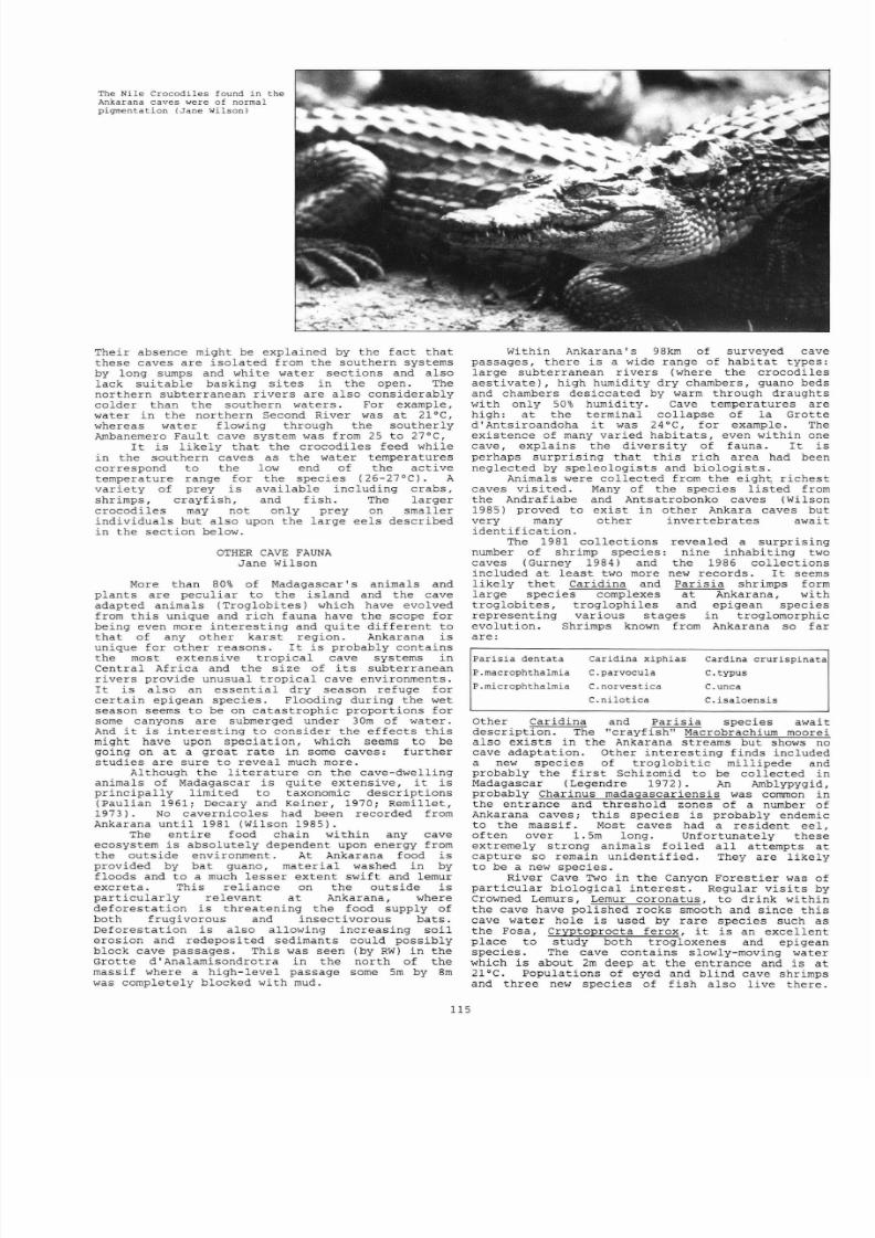
8/21/2019 BCRA 14-3-1987
http://slidepdf.com/reader/full/bcra-14-3-1987 27/52
The Nile Cr
ocodi les
f ound
in
the
Ankarana caves
were of
normal
pigmentat ion Ja ne Wils on
Their absence
might
be explained by
the fac t that
these caves
are i so la ted from the southern systems
by
long
sumps
and
white water
sec t ions
and
also
lack
su i tab le basking
s i t e s
in the open. The
nor thern
subterranean r ivers
are
also considerably
colder than the southern waters . For example,
water
in
the northern Second
River
was
a t
21°C,
whereas water
flowing
through the southerly
Ambanemero Faul t
cave system was
from 25 to 27°C,
I t is
l ikely that the
crocodi les
feed while
in the
southern
caves as the water temperatures
correspond
to
the low
end of
the ac t i
ve
temperature
range
for the species (26-27°C). A
v
ar i e ty
of prey is avai lable including crabs,
shrimps, crayf i sh , and f i sh
.
The larger
crocodi les may
not
only prey on smal ler
indiv iduals but also upon the large ee l s
descr ibed
in
the sec t ion
below.
OTHER CAVE FAUNA
Jane
Wilson
More
than 80 of Madagascar 's
animals
and
plants
are
pecul ia r to the
i s land
and the
cave
adapted
animals
(Troglobi
tes
which have
evolved
from
t h i s
unique
and
r i ch fauna have
the
scope for
being even more
in teres t ing
and qui te
dif feren t
to
that
of any other
kars t region. Ankarana is
unique for o ther
reasons
. I t i s
probably
contains
the most extensive
t rop ical
cave systems
in
Central
Africa
an
d the
s ize of
i t s
subter ranean
r ivers provide unusual t rop ical
cave
environments.
I t
i s also
an essent ia l
dry
season
refuge for
cer tain
epigean species .
Flooding
dur ing the wet
season seems to be on
catast rophic
proport ions for
some
canyons are submerged
under 30m
of
water .
And
t
is
in teres t ing
to
consider
the
effects
th i s
might
have
upon
specia t ion , which seems to
be
going
on a t
a
great
ra te
in
some
caves:
fur ther
s tudies are sure to reveal much more.
Although
the l i t e r a ture on the cave dwelling
animals
of Madagascar i s
qui te
extensive, t i s
pr inc ipa l ly l imi ted to
taxonomic
descr ip t ions
(Paul ian
1961;
Decary and
Keiner , 1970;
Remil let ,
1973) .
No cavernicoles had been recorded from
Ankarana un t i l 1981
(Wilson 1985) .
The en t i r e
food chain within
any cave
ecosystem i s abso lu te ly dependent upon
energy
from
the outside
environment.
At Ankarana food is
provided
by ba t guano,
mater ia l washed
in by
f loods
and
to a much l esser extent swif t
and
lemur
excreta .
This rel iance
on the outside
is
par t icu lar ly
re levant
a t
Ankarana, where
deforestat ion
i s threatening
the food supply
of
both f rugivorous and insect ivorous
bats .
Deforestat ion
i s
also allowing increasing so i l
erosion and redeposi ted sedimants could
poss ib ly
block
cave passages.
This was seen
(by
RW)
in the
Grot te
d'Analamisondro
t r a in the
nor th of
the
massif where
a
high
level
passage
some
5m
by
8m
was
completely blocked with
mud.
l15
Within Ankarana's
98km
of
surveyed
cave
passages, there
i s a wide
range of habi ta t
types:
large subter ranean
r ivers (where the
crocodi les
aes t i vate , high humidity
dry chambers, guano beds
and
chambers desiccated
by warm
through draughts
with
only
50 humidity. Cave temperatures
are
high: a t
the terminal co l lapse of
la
Grot te
d'Antsiroandoha t
was
24°C, for
example. The
existence
of
many varied
habi ta ts ,
even within
one
cave, explains
the
divers i ty
of
fauna. I t
i s
perhaps surpris ing that
th i s
r i ch
area had
been
neglected by speleologis t s and
bio logis ts .
Anima l s
were col lected
from
the i g h ~
r i ches t
caves v i s i t ed
. Many of the species l i s ted from
the
Andrafiabe
and
Antsatrobonko caves (Wilson
1985) proved to
exi
s t
in
other Ankara caves
but
very
many other
invertebrates await
ident i f icat ion
.
The
1981 col lec t ions revealed a
surpris ing
number of shrimp species: nine inhabi t ing two
caves
(Gurney 1984) and
the
1986
col lec t ions
included a t lea s t
two more
new records . I t seems
l ike ly
t he t
Caridina and Par i s ia shrimps form
large species complexes a t
Ankarana,
with
t roglobi tes ,
t roglophi les and
epigean species
represent ing var ious stages
in troglomorphic
evolut ion
. Shrimps known from Ankarana so
far
are:
Par i s i a dentata
P.macrophthalmia
P.microphthalmia
Caridina
xiphias
C.parvocula
C norvestica
C.ni lo t i ca
Car dina crur i sp inata
c.typus
C. unca
C.isaloensis
Other Caridina and Par i s ia species await
descr ip t ion .
The
crayfish Macrobrachium
moorei
also
exis ts in
the Ankarana streams but
sh
ow s no
cave
adaptat ion .
Other
in teres t ing
f inds
included
a new
species
of
t rog lobi t ic mill ipede and
probably the f i r s t Schizomid
to be
col lected
in
Madagascar (Legendre 1972). An
Amblypygid,
probably Charinus madagascar i ens i s was
common
in
the ent rance and threshold
zones
of a
number
of
Ankarana caves; t h i s species
is
probably endemic
to
the
massif . Most caves had
a res ident
eel ,
of ten
over
1.5m
long.
Unfor tunately
these
extremely strong animals fo i l ed a l l
at tempts
a t
capture
so remain unident i f ied.
They are
l ikely
to be a new species .
River Cave Two in
the
Canyon Fores t i e r was of
par t icu lar biological
in te r es t . Regular v i s i t s by
Crowned
Lemurs,
Lemur coronatus . to
dr ink
within
the
cave
have
polished rocks
smooth and
since t h i s
cave water
hole i s
used
by
rare
species such as
the
Fosa,
Cryptoprocta
ferox,
t i s an
excel lent
place
to
study both t rogloxenes
and
epigean
species .
The
cave contains
slowly-moving water
which i s
about
2m
deep a t
the entrance and i s
a t
21°C. Populat ions of eyed and bl ind cave shrimps
and three new
species of f i sh also l ive there .

8/21/2019 BCRA 14-3-1987
http://slidepdf.com/reader/full/bcra-14-3-1987 28/52
Two
Glossogobius
species (Peter Mil ler , pers comm
1987)
have
eyes,
are pigmented and presumably
ar r ived ( jus t
as
t he i r next meal wil l ar r ive)
by
way
of
f lood
waters . In te res t ingly
, some
of these
f i sh
were found
in
a
deep pool
which
was
glazed
over
by a mm layer of ca lc i te .
The th i rd
f i sh ,
probably
a
Gobius sp . ,
i s a
tog
lob i
te
and
was
found
even in
the Entrance and Threshold zones of
t h i s
cave . This is
almost cer t a in ly
endemic to
Ankarana which impl ies t i s r e s t r ic ted to to
r ivers flowing within
a
range perhaps measuring
10
x 30km .
Like
the 39 known species
of
t rog lobi t ic
f i sh t should be considered an endangered
species .
USE
OF
CAVES
BY LEMURS
Jane Wilson
and Paul Stewart
Accessible
drinking water for both people and
animals
i s
a t
a premium a t Ankarana dur ing
the dry
season.
The
most
r e l i ab le
water holes were
a t
cave entrances and lemurs and
other
wild l i fe were
regular ly observed drinking a t
·
the entrances
of
the Second
River Cave
(G14a),
la
Grot te
d Andraf iabe (G7) and
a t
the Syyx River
Cave
(G5).
I t
i s
l ikely that
lemurs
have
neede
d
to use
cave water
holes a t
Ankarana
for
centur ies and
t h i s might explain why the su b - foss i l s i t e ins ide
the Grot te
d Andra
f iabe i s
so
r i ch . All skeletons
were found
j u s t
beyond
the
l imi t
of
l i gh t
penet ra t ion
and most
were
complete skeletons which
must have ar r ived in the
cave while the
carcass
was
r e l a t ive ly
in t ac t . Many were lying on tops of
boulders in po
s
i t i ons incompatible with having
been
washed
in
by
f loods
.
We were unable
to
f ind
any avens nor any evidence
suppor t ing the idea
that
th e bones cou l d have ar r ived by
fal l ing
through a hole in the roof . No
ta lus
cones were
evident
in
the cave
system.
The
most
l ikely explanat ion for the ar r iva l
of the lemurs a t t h i s s i t e i s
that
they had come
into the cave
,
probab
l y
to drink
a t
a
water hole
sub-fossi l ized lemur bones found ins ide
Grotte d Andrafiabe.
Two
skulls
of
Hapalemur
simus are
on the le f t and the sKull
of a
Mesopropithecus
is bottom r ight
(Jane Wilson)
in the
cave entrance, and were
scared
in to
the
cave
by a
predator ( the Fosa, Cryptoprocta
ferox
wil l
take
lemurs and
seemed to
be
hunt ing
Crowned
Lemurs
a t
the Second
River
Cave) . When
fr ightened, lemurs of ten f lee upwards and once
they had f led beyond the l imi t of l igh t
penet ra t ion they would have
been unable
to f ind a
way out .
There
i s a
r e l i ab le
water
source
in the
Dark Zone j u s t beyond the sub- foss i l depos i t s but
t
seems
unl ike ly
that
lemurs could have
navigated
to
t h i s
in
absolute
darkness.
Carcasses
lying in
the
cave s
Dark Zone would
be
unavai lable
to
scavengers and also pro tec ted from the decomposing
effects
of
l ea f l i t t e r
.
This explains
why
more
foss i l s
have
not
survived in
Ankarana
s
i so la ted
fores t s .
None of the lemurs repesented as sub- foss i l s
a t t h i s s i t e st ll
s urvive
a t Ankarana as far as
we know and
Ankarana
s
extant lemur species were
poorly represented in
the
remains .
This
i s
consis tent
with the dr inking hole hypothe s is since
the
entrance
water hole
no
longer contains water
dur ing
the
dry season.
PALAEONTOLOGY
Martine
Vuillaume-Randramanantena
and
R
Ralaiar ison
-
Raharizel ina
The
Grot te d Andraf iabe
In
1981 members
of the
Southampton
Universi ty
Expedi t ion discovered a skul l and limb bones
of
four
Greater Bamboo
Lemurs,
Hapalemur simus
(Wilson
1985). At th is time
museum
skeletal
specimens
of
th is
species
t o t a l l ed
only
about
15
worldwide (Vuillaume-Randriamanantena
, Godf
rey and
Suther land
1985) .
The
s e
f inds implied
that
Ankarana might prove worthy
of a
special
palaeontological survey. When we
v i s i t ed
the
same
cave
in
1986, the sub
-
foss i l s i t e a t la
Grot te
d Andraf iabe,
proved to be
unusual ly
r i ch .
We were able to
col lect bones
of 18
Hapa
l emur
simus which i s a grea t concentrat ion of ske l etons
l fa lemur ra re ly found in su b - foss i l s ta te . We
l e f t other sub- foss i l s in
s i t u
since they were too
securely
cemented
to enable us to remove them,
with the l imi t
ed
equipmen t we
car r ied
, without
damage. Most sub- foss i l s (90 ) were of Hpalemur
simus
.
An
unident i f ied
t i b i a
(a lower
leg
bone)
probably
a pathological lemur
bone was also
col lected
and
skeletons
of Lemur sp. were seen.
Nearby were
skul ls
of
p r o ~ u s
diadema and
Mesopropithicus. Propi thecus
has
not been
recorded from Ankarana previously
a
nd
Mesopropi thecus
which
is now
ext inct , was
known
only from a
very few specimens col lec ted
more than
50
years
ago
in cent ra l and southern Madagasc
a r .
The
f i r s t Mesopropithecus was described
by
Standing
in
1905 and others were found
by
Lamberton in 1937
and
1939. The l a t t e r f inds were
in
the cave s i t e of la
Grot te
d Ankazoabo
on
the
south-west coast of Madagascar (Lamberton 1939,
1946
,
1948). The
1986
f inds
i
ncluded
previous ly
unknown
bones of the Me s opropi thecus which give
valuable new information cont r ibut ing to knowledge
of
the animal s l i f e s ty le (Vuillaume - Randriaman
antena
and
Ralaiar ison - Raharizel ina
1987).
One
of
the
most in teres t ing qu e
s
t ions
unanswered by palaeontologis t s , i s
the
age
of
lemur su b -
fo ss i l s
.
The
mo s t ancient Malag
as
y
s ub -
fo ss i l s
do cumented are from the deepest
depos i t s a t
Ampazambazimba;
these are
about
8000
years old (MacPhee,
Burney
and
Wells 1985).
More
commonly
age e s t imations f a l l
between 2000
and
1000 years
before
present
(Dewar
1984) .
Other
researchers
,
re ly ing
on
ora l evidence and
repor
t s
of ancient
t r ave l l e r s
l ike Flacourt
(1661), fee l
that
the l a s t Madagas car dwarf hippopotamus and
the
l a s t f l i
ght less elephant bi rds
on l y
disappeared a
few
centur ie s
ago. Sadly
there wer e
few
sediments
a t the
Andrafiabe
sub- foss i l s i t e s o
excavat ions would
be unl ike ly to revea
l f
urther
informat ion
on the age
of
the sk e
l etons a l t hough
accurate
da t ing
would
be po s
s ib le i f
some
bones
were
sacr i f i ced
.
The
remains
seem
to
span
a
l a rge
t ime
scale
. Some of the s ub - f oss i l s m
ight
be a
f ew
hundred
years o l
d, others including bi rd an
d
f ru i
t bat bones
are probably a t
most a
few
years
old.
116

8/21/2019 BCRA 14-3-1987
http://slidepdf.com/reader/full/bcra-14-3-1987 29/52
Micromammal Remains
in
Other Caves
We
searched numerous rock she l te r s for
ske le ta l remains and severa l proved to
have
r ich
deposits
of
recent or ig in .
The
r i ches t was from
the
Grot te
Trans-sept , in
the nor th wal l
of Canyon
Fores t i e r . I t
seems
tha t a t
Ankarana
cosmopolitan
rodents
have
not
yet
supplanted the
local
rodents
which are endemic to Madagascar. In the Ankarana
rock s he l t e r s
surveyed,
skeletons of loca l rodents
outnumbered those of
int roduced
species . This
i s
in
grea t
cont ras t to
the bones
found in
the
caves
of
Anjohibe
or
in
caves
in
the
cent re
of
Madagascar. On the cont rary , int roduced
r a t s
and
mice
represent
the
majori ty of species in
these
more southerly caves.
Par t
of
the zoological
work of
the expedi t ion
was
to at tempt a comprehensive inventory of a l l
animals inhabi t ing Ankarana , both in
caves
and
on
the
sur face . We expected to compile a
spec ies
l i s t of
the loca l
small mammals
using Longworth
Traps.
However, even
i f
the
f re ight shipment
conta in ing
the t raps had ar r ived , such a
survey
would have fa i l ed since mo s t small mammals
were
aes t iva t ing
and inac t ive
.
Skele ta l
remains found
in
the rock s he l t e r s therefore
provided
unexpected
informat ion on the ecologica l
i so lat ion
of
forests
within
the Ankarana Massif.
RCH EOLOGY
Jane
Wilson
Madagascar was probably only f i r s t se t t l ed by
man about 2500
years ago.
The f i r s t
s e t t l e r s were
thought to have ar r ived
by
boat
from
Indonesia
and
the
voyage
across the Indian Ocean in a
large
out - r igger canoe was proved to be poss ib le by the
Sarimanok Expedit ion in 1985. Early
archaeological discover ies are therefore
most
unl ike ly , al though some people think tha t there
was a populat ion
in
Madagascar before the
Indonesian se t t lement . When we discovered
pot tery,
f i r e
places
and other evidence of human
set t lement a t Ankarana
we
f i r s t
assumed
t h i s to
be
ev
id
ence
of people
hiding
a t Ankarana
between
1835
and
1838
when loca l
people
were hounded by the
so ld ie r s of Radama I . This may
be the
or ig in o f
some
ar t i f ac t s
but
t
seems probable tha t
the
archaeological
remains
are
f r
om
a
range
of
dates.
The
Ankarana shards show
s imi l a r i t i es with
pot te ry
used on the i s lands
off Madagascar s
nor th-west
coas t s dur ing the XVI XVIII centur ies
(Dr
Hilar ion
Rakotovololona,
Musee de l Univers i t e ,
Antananarivo:
per s
comm, 1987). Dr Bob Dewar
(Universi ty
of Connecticut) fe l t t ha t
the pot te ry
photographed
in
the huge entrance
of
the Grotte
d Antsi roandoha had been del ibera te ly l e f t in
caves
as offer ing s to a sp i r i t
or
as par t
of
a
funerar
y ceremony.
Ankarana seems
to be a r i ch
archaeological s i t e ,
worthy
of spec ia l i s t
a t ten t ion .
CONCLUSIONS
Phil Chapman
The kars t
and
caves
of Ankarana, al though
packed
into
a
small area of l imestone,
rank
with
other grea t kars t i c regions of
the
t ropics such as
the
Mulu Caves
in
Sarawak
or the Guangxi towers
in
China.
The int imate re la t ionship
between
c
ave
waters
of Ankarana
and the
wi
ld l i f e - r ich
fores t s
which
they
suppor t , lends the
caves
a biologica l
s igni f icance
over
and
above tha t
afforded
by t he i r
r i ch cavernicolous faunas.
The caves
also hold
important palaeontological
and
archaeological
remains.
Yet the area faces an
uncer ta in
fu ture .
Local, l a rge sca le
defores ta t ion maybe
increasing
s i l t i ng within
caves
and i s
posing a d i rec t th rea t
to
many fores t species.
Reducing
fores t habi ta t s
i s
l ikely
to inf luence
the
food supply of cave
commun
i t i e s
which depend upon bats , swi f t s , e tc .
Uncontrol led
hunting threa tens Ankarana s
unique
subter ranean
crocodi les .
In te rvent i on i s
r equi r ed
soon i f t h i s unique
area i s
to be safeguarded for
the
fu ture . The
Malagasy
Government
has
the po l i t i c a l
wil l
to
117
protec t Ankarana, but sadly lacks the necessary
resources.
Thus
an
ambitious
conservat ion projec t
i s underway to
extend
the work presented in
t h i s
repor t . In autumn
1987
a
small
team ,
including
some members of the 1986 Crocodile Caves of
Ankarana
Expedition, wil l make a f i lm about
the
area, i t s caves
and
wild l i fe
and t conservat ion
needs.
A
para l l e l
research
projec t ,
involving
mainly Madagascar -ba sed personnel , wil l aim to
draw up a Management Plan
for Ankarana
which wi l l
be
implemented using money ra i sed by
publ ic
appeal
through
in te rna t iona l
conservat ion
organisa t ions .
We hope tha t the
Crocodile
Caves of Ankarana
Expedit ion has
s tar ted
a process
which
wi l l
eventually
lead
to the permanent protec t ion of
t h i s superb
area
for
the enjoyment
of
cavers,
sc i en t i s t s
and the people
of
Madagascar.
KELIFELY REC O
NN ISS NCE
Dave Checkley
The Ke l
i f
e l y pl atea u , wi t h 8000 sq km o f l mes t o
ne,
i s
the
second
largest
potential caving
area
in
Madagascar. I t
i s reputedly nearly
a l l Jurass ic limestone (Balazs 1980), and
i s
approximately
60km
long
by
50km
wide.
The
southern
scarp
r ises
nearly
1000m above the surrounding plain .
Kelifely i s in a f a i r l y remote area , 250km north - west of
Antananarivo
and 600km south west
of
Ankarana. Road access
may
be
di f f i cu l t since several river crossings
are
required
and
the
ferr ies no
longer
operate.
However,
there
are
regular
f l igh t s
fr om
Antananarivo
to Ambatomainty, a
v i l lag e
25km
south of
the massif
with
a good dry
weather
ai rs t r ip .
The
Mahakamba
River
l i e s between
the massif and Ambatomainty,
but
t h i s probably d r ies up
for
some
of
the
year ,
as does the
larger Mahavavy River to the eas t
of
the massi f .
The only people to look for caves in the region
previous ly
were a French team that v i s i t ed the most nor ther ly
area of Kelifely (Peyre e t a l 98 and 1983). They
found
no
s igni f icant caves, but their movements
were severely
r i s t r ic ted by the presence of bandi ts
in the region.
The
French approached
the
massi f from the
town of
5 i tampiky in
the nor th and
did
not reach the
massif
proper . Bandits
are
no longer a
s ign i f i c ant problem.
e chartered a
four-seater
aircraft through
Madagascar
Airtours in Antananarivo at approximately
£400
for
the
afternoon. We
f le
w direct ly to Keli fely across the
dry
plains .
From
Ambatomainty
we
flew
s t ra ight
up
to
and
along
the southern
scarp.
West of Arnbatomainty the scarp i s steep
and cont inuous .
t
has very
fe,,
breaks in
t
and only
occasional patches of
woodland
in the shallow val leys
incised
into
i t .
To
the nor th eas t
o f Ambatomainty
a t the base
of
the
massif
there i s an
incredib le landscape
of
tor tuous canyons.
These winding,
steep-sided
gorges
were
c l ose l y intertwined
over a
huge
area . The
gorges
were perhaps 30m deep and
were
so closely
packed
th a t the area presented a vi s t a of endless
rocky pinnacles running up to
the
Keli fe ly scarp . There was
no water in
any
of these gorges and no obvious caves at the ir
heads in
the
massif . Woodland
did
however obscure many of
these
val ley
heads. At
many gorge
heads were steep c l i f f s ,
but
with no sign
of caves at
their bases. The
red sandstone
in which the gorges
have
formed ( Isalo formation)
must
be
very
soft
to have been
so
heavily eroded
by
the
l imited run
off
from
the Keli fe ly
scarp .
The scarp in t h i s area has a
stepped appearance with small (?l imestone)
c l i f f s
and
intervening grassy
or sometimes
wooded
s lopes .
North of the scarp is a plateau, an
extensive
area of
grassland sloping very
gent ly
northward. These grasslands
are
only
occasionally
punctuated
by clumps
of trees in
shallow depressions and by the winding, tree l ined
river
val leys . e saw
only
one region of apparently broken
l imestone
pavement
and a
few
shallow dol ines . We followed
the
two major
rivers
draining the plateau for their entire
lengths the
Kiananga
and Tsiamadiovolana Rivers) . Their
blue green waters occasional ly plummeted perhaps S m down
great
round
bowls,
forming spectacular waterfal ls . We could
not
be certa in that there were no caves at
the
bases o f these
wooded
bowls, but the
r ive r
gorges
cut out of
these
bowls a t
their far s ides appeared to
carry
the same quantity
of water
as went in
at
the
top.
The
fur,ther north
we went
along
these
t r ibu ta r i e s
of
the Mahavavy
River,
the wider
and more
wooded
t he i r valleys became. However ,
even
in the higher f requent ly
c l i f fed
gorges of these rivers
we
saw not a s ingle cave
entrance . The
r iv e r s
always flowed
on
the surface and
genera l ly there
were very few kars t features .
We
flew
as
f a r
nor th as the
Kasijy Forest .
Although we did not l and a t Keli fe ly we flew
within
20m
of much of the surface of the massif for one and a h a l f
hours . We were unable to ce r t a in ly
id en t i fy
any cave
entrances. I do
not th e r e f ore
bel ieve that
the
area i s
worth
a
major
speleological expedi t ion .
This
conunent
i s
made
in
the knowledge
th a t a small Malagasy team
(based in
Antananarivo)
wi l l vis i t
the
area
t h i s year (1987). I t wi l l
be i n t e res t ing to
see
what they f ind , but the development of
major cave systems in the
area
does not seem
very
l i ke ly .

8/21/2019 BCRA 14-3-1987
http://slidepdf.com/reader/full/bcra-14-3-1987 30/52
MEDICAL REPORT
Jane Wilson
During
the
dry
season
which is the most practicable time
to work at Ankarana, the dearth of
water
on
the surface makes
it
a
remarkably
pleasant and heal thy
place
to be.
I t hardly
rains so tents are
unnecessary, there
are no insects and the
only noxious animals are
the.scorpions and
centipedes. These
animals
do not real ly become
a
nuisance
unt i l the
ear l ies t
ra ins in October,
which
i s about the time th a t the bi t ing
insects appear. The largest and most unpleasant scorpion i s
Groophus palpa tor and the two of
us who
were stung by these
were
in great pain with rigors ,
sweating,
etc for 24 hours
and
unwell
for
severa l
days
subsequent ly .
Pain
a t
the
s i t e
of
the
s t ing
resolved
after just
over a
week but
one
victim
was
l e f t
wi th an anaesthetic
f inger for a month. Powerful
pa in-k i l l e r s preferably opiate analgesics , should be
availab le for the f i r s t
24
hours a f t e r
such a s t ing. We
used
susta ined release Morphine
t ab le ts ,
but parentral drugs might
h
av
e
been more appropria te
.
Sc o rpions favour hiding in dark
corners dur ing
dayl ight
hours
and even
manage
to
f ind t he i r
w y nto rucks ck pockets when t h s been suspended on
tree. Great
care i s needed
to
avoid
st in
gs
which
are
reputedly
r a r e ly fa t a l
on Madagascar (see also Wilson 1987) .
Another important health r i sk a t
Ankarana
i s from
trauma; the
t s ingy
i s sharp
and unstable and
very abrasive.
Strong boots
and
l ea th er gloves helped to pro tect
us
and
we
were fortunate
that
our most
serious
accident was a
l ace r a t io n
from a palm leaf .
Other
problems included t r ave l l e r s diarrhoea and
sickness;
Lasoni l
proved helpfu l
subsequent ly
f
or soothing
over-act ive
anal
sphincters. Several of us were
troubled
by
mouth
u lcer s
which we
eased by
Te e - je1 . Three of us
caught
worms
which
were diagnosed and
treated after
we returned to
Brita in .
We
s tayed hea l thy
because
o f
the easy
condi t ions
a t
Ankarana,
having the
right irrununisations
and malaria
prophylaxis and good
camp
hygiene (with
a
l a t r ine and
compost
heap away from the
l iv in g a r ea ) .
We acqui red most g as t ro
in tes t ina l problems while we were
sampling
the exce l lent
Malagasy food that i s availab le
in
the towns . These usually
se t t led within 24-48
hours
takihg only clear
f lu id s
but one
o f us required a
course
of
Flagyl (Metronidozole)
for
presumed
gia rd ias i s .
Malagasy doctors
and lo ca l
Aides
Sani ta i res
are well t rained and very competent but
the
serv ice they can offer i s ext remely l imi ted due to
shortages
of drugs and medical suppl ies
. A
more comprehensive account
of the medical
aspects
of the
Expedi t ion,
including
a l i s t
of
drugs
taken, i s in
our
repor t (Chapman e t a l
1987a).
ACKNOWLEDGEMENTS
We are
indebted to the
Malagasy author i t i e s
for
permission
to
conduct
this
survey
and to
Drs Lee
Durrell
and
Alison Richard In te rn a t io n
a l Group
of Sc ient i s t s ) ,
Dr
Jon
Pollock,
Shane
Winser,
Diana Hancock, Dr David
Harding, Tony
Wal
tham,
Mike
Sal isbury,
Mrs
A
Trimble,
Ruth
Mindell ,
Ben
Lyon and Dave Ell io t for advice and
contacts
and
to
Simon and
Cather ine
Howarth, Andy
Cairns, ill and David Wilson,
Anthony
Orr, Ian Looker, Howard Jones, Tony Gunn, Ian Redmond
and
Jane
Darr ington for i nva luable
help.
David ar.d Lucy
Andriamparison, Dr Voara Randrianasolo, Benjamin LeNormand,
David Curl and many others
ass i s ted and encouraged
us while
we
were in
Madagascar.
The p ro jec t
rece ived
funding
from
the
Spor ts
Council ,
Ghar Parau ~ o u n d a t i o n
Royal
Geological
Society
Bri t i sh Sugar
Award),
Bri t ish
Ecological
Socie ty ,
Smith
Kline
and French; Duke
of
Edinburgh
Trust, Scient i f ic
Explorat ion
Socie ty , John
Spedan
Lewis Trust , Bri t i sh Museum
(Godman Fund) , Twenty-Seven
Foundation, Royal
Botanic
Gardens, Kew for seed col l ec t ions ) . Sir Peter Scot t
kindly
acted
as
ou
r
pat ron and
Dr
Peter Edwards (Biology Dept . ,
Univers i ty of
Southampton)
and
the
l a te
Dr G T Jef ferson
acted as academic referees . We received
approval
from the
Primate
Socie ty and
the
academic suppor t of
the
Univers i t ies
of
Southampton,
Hull and
Wales.
The fol lowing
companies were
esp ec ia l ly generous in supplying t he i r products :
AJBB
Plas t i c s , Alcan; Alexandra
Workwear;
Bayer,
BDH
Chemicals;
Berk, Boots , BTR Boots; Carton In d u s t r ies ,
Caving Supplies;
Chance
Propper;
CPL
f i lms;
Dearlove Blue
Drums;
Duncan
Flockhar t Co; Endecotts; Fisons , Gold
Cross;
W Gore;
Hampton Prin ting;
Hanimex; In te rn a t io n a l
Fre ight
Forwarders;
I tona ;
Janssen; Kodak
; Leder le ; Lyon Equipment;
May
and
Baker, Mossley Wool Combing and Spinning;
Napp; Nelsons;
Oxoid;
Paramorr
Electronics ,
Pel l ing Cross;
Pfizer;
Phoenix
Equipment, Polaroid;
Prest ige; Roche;
Smith
Kline and French,
Smith
and
Nephew; Surviva l
Aids;
Varta Batteries ; Winit
Boots . We are g ra te fu l to Mr
J E
Hi l l and Joan El l i s for
prompt
ident if icat ion
s of the bats and shrimps.
The
expedi t ion
members were Jane
Wilson
and Phil
Chapman
co-leaders) ,Dave
Checkley, Simon Fowler,
Shiels Hurd,
Mick
McHale, Jean Radofilao (formerly Duflos) (C.U
.R . ,
B.P .O. ,
Antsiranana), Raobivelonoro Ralaiarison -
Raharizelina
and
Martine Vuillaume -Randr iamanantena (Service de Paleontologie ,
Universi te de Madagascar, B.P.
906
,
Antananarivo 101),
Guy-Suzon
Ramangason Department de Botanique, Universite de
Madagascar) , Jean - Elie Ranctriamasy Parc Tsimbazaza,
Antananarivo)
, Paul Stewart and Roo Walters. Dave Clarke,
Sally Crook, Ann Denning,
Ben
Gaskell and Maggie
Hutchings
also
helped
with the f i e ld
work.
REFERENCES
Adamson, A P, Boase, M J
Howarth,
C J, Wilson, J M and
Wilson
M
E,
1984.
Southampton
Universi ty
Madagascar
Expedit ion
1981
. Universi ty of Southampton 136pp.
Balazs, D. 1980.
Madagaszkar karsztvidekei.
Karszt es
Bar lang (Budapest)
vol
1, 25-32.
Blanc,
C P ,
1981
Batrac iens e t Repti les : formes e t couleurs
inso l i t e s . In
Madagascar, Un sancuaire
de
la nature
.
Ed.
P Oberle.
Lechaval ier , Par i s .
Blanc,
C P,
1984
.
The
r ep t i le s .
In
Madagascar: Key
Environments ser ies eds
A
Jo l ly ,
P
Oberle and
R
Albignac. pp 105-114. Pergamon, Oxford.
Chapm
an,
P ,
Ch eckley,
D,
Fowler,
S V, Hurd,
S, Ramangason
, G
-5,
Randriamasy, J -E, McHale,
M
Stewart,
P, Walters,
R, and Wilson, J
M
1987a. Crocodi le Caves of Ankarana
Expedition
Report.
editor R Walters; private
publicat ion .
Chapman, P ,
Checkley,
0, Fowler, S v ,
Hurd,S ,
Ramangason, G
-5, Randriamasy,
J -E, McHale,
M
Stewart, P, Walters,
R
and
Wilson,
J
M. 1987b.
A
survey
and
management
proposa ls for a tropica l deciduous forest reserve at
Ankarana
in
northern Madagascar. Submitted to
Biologica l
Con
se rva t i on
.
Decary, R, and Keiner, A,
1970.
Les cavites soutarraines de
Madagascar. Annales de
Speleologie
vol . 25,
pp409
- 440 .
DecarY ,R
, and
Keiner,
A, 1971. Inventaire
schematigue
des
c
av
i t e s de Madagascar. Annales
de Speleologie
vol . 26,
pp31-46.
Tr
oo
p
of Crowned Lemurs
enter ing
the Second River Cave
to dr ink
(Jane Wilson)
118
8/21/2019 BCRA 14-3-1987
http://slidepdf.com/reader/full/bcra-14-3-1987 31/52
Dewar, R. 1984. Ext inct ions in Madagascar ;
the
loss o f
the
sub-fossi l
fa un a
. In Quaternary Exti nctions: a
prehistoric revolution eds. P S Martin and R G Klein.
Universi ty
of
Arizona Press ,
Tucson;
pp547-593
.
Dorst, J . 1948.
Essai d une
c le f de determination des
Chauvre-sQuris
Malgaches. Mem.
Inst . Sc i . Madagascar A
1
1)
81.
Duf les , J . 1966. Bilan des ex
p lorat ion s
spe leo log iques pour
l 'annee 1965. Revue de Geographie (Universi te de
Madagascar)
vol
9 pp235-252.
Du f 10 s ,
J .
1968. Bi1an des
ex p lo ra t i o n s pour l ' an n ee
1966.
Revue
de
Geographie
(Universite de
Madagascar)
vol
12,
pp121-1 29
.
F1acourt, E
de 1661.
H is to i r e
de
la
Grande
I s l e
de
Madagascar. Gervais-Clouzier Paris,
471pp.
Gurney,
A R.
1984. Freshwater shrimp genera
Carid ina
and
Parisia of Madagascar with descript ions of
four new
species .
J .
Nat. Hist .
vol
18,
pp 567-590.
Lamberto n, C 1936
(1937)
.
Fo u i l l es
paleonto10giques fa i t e s
en 1936
.
Bull .
Acad .
Malagach
e vol
19,
ppl-19 .
Lamberton,
C
1939. Contribution
a
1a connaissance
de
1a
subfossi le de Madagascar. Lemuriens et Cryptoproctes.
Note
4.
Mem . Acad.
Malagache vol 27, pp9-49
.
Lamberton,
C
1946 (1948)
. Cont r ibut ion a
la
connaissance
de
la faune
subf oss i l e
de
Madagascar . No te 20 Bul l . Acad .
Malagache vol 27 , pp30 - 34.
Legendre,
R
1972. Les Arachnides
de Madagascar,
in
Biogeography
and
Ecology
in Madagascar . eds R B a t t i s t i n i
and G Richard-Vindard. Monographiae
Biolog icae
Vol 21 ,
(Junk, The Hague)
pp427-457.
MacPhee,
R D
E, Burney,
D A
and Wells ,
N A,
1985. Early
Holocene
chronology
and environment o f Ampasarnbazimba a
Malagasy
subf oss i l
s i t e .
I n te r na t . J Primato l
vol 6
(5) , pp463-490.
Paulian,
R 1961 . La
faune cavernicole .
In: Faune de
Madagascar XIII : La
Zoogeographie
de Madagascar e t des
I les Vo i s ines .
Inst itut de
la Recherche Scienti f ique ,
Tsimbazaza
Antananarivo pp94-99
.
Paul ian ,
R 1981 . Les Mammiferes: vest igues
d 'un
monde
disparu
.
In Madagascar, Un sancuaire
de la
nature. Ed
P
Ober le .
Lechaval ier ,
Paris .
Peyre, J - C
e t a l 1981. Madagascar
- Expedi t ions
speleo logiques: CANOPUS
81
and K el i f e ly 81.
Sp e
1eologie
115 Speleo
Club Martel , Nice
/C lub
Alpin Francais .
Peyre,
J - C Arthaud, G
Bessaguet,
D
Fulcrand, 5,
Martin
M
Radofilao,
J,
Flandin
J -M and
Tessier , F. 1982.
Expedi t i on Speleologique : Madagascar 1982. Club Alpin
Franca i s
/Federat ion
f ran ca i s de spe leo lg ie .
Peyr
e , J
-C e t a l 1983. Kel i f e ly
83 -
Reconnaissance
Speleo10gique. Club Alpin Franca i s
.
Peyre,
J -C, Bessaguet, D Curtare l l i , T, Franco, E
and
Radof i l ao ,
J .
1984. Speleologie :
Special
Madagasca r .
Bul l .
Club
Marte l , Ni
ce/C
lub
Alpin Francais .
Peyre, J -C
e t a l
1985. Ex plo r
a t i o n
Spe leo log ique dans
l Ile
de
Madagascar. Bull .
Club Marte l , Nice / Club
Alpin
Franca
i s .
Radof i l ao , J 1877. B il an des
ex
plo ra t ions spe leologiques
dans l Ankarana
. A
nna
les
Univ. Madagascar. Se r
:
sc i
na t
math. vol 14, pp195-204.
119
Ravelonanosy,
C and Duflos , J . 1965. Bilan des
explorat ions
speleo10giques pour l 'annee 1964. Revue de Geographie
(Universi te
de Madagascar) vol 6, ppl1
7 -
132
.
Remillett , M 1973. Apercu de la faune
souterraine
a
Madagascar. Li v re du Cinquantaire de l Ins t i tu t de
Speleologie Emile
Ra
co
vi tza ,
Buchares t
pp135-160 .
Rossi,
G 1973. Problems morphologiques du karst de
l Ankarana.
Revue de Geographie (Universite de
Madagascar) vol 23.
Rossi , G 1874. Morphologie
et
evolution d un
karst
en mil ieu
tropical:
l Ankarana.
Memoires e t
Documents
CNRS
nov.
se r
.
15:
Phenomenes Kars t iques I I ,
pp279-29S.
Rossi ,
G
1975 Resultats
de
deux annees
de
mesures de
teneurs
en calcium carbonate d un resurgence
karstique
t r op ica le . Spelunca vol 2, pp27 - 28 .
Rossi, G 1976a Karst et d i s so lut ion
des
calcaires
en
mil ieu
t rop ica l . Z. Geomorph.
N. F.
(Ber l in) vol
26
pp124-152.
Ross i , G
1976b.
Problems biogeographiques
de l 'ex t reme
-
nord
de Madagascar. Madagascar, Revue
de
Geographie
(Universi te
de Madagascar) vol 28 pp
133-154.
De Saint
Our
s , J 1959. Les phenomenes karst iques
a
Madagascar . Annales de Spe1eologie vol 14
Standing , G
-F
1905
(1906). Rapports sur l e s ossements
sub- f
oss
i l e s
provenant d ' Ampasambazimba.
Bul l . Acad.
Malagache (an.
se r . ) vol IV,
pp95-100.
Vuillaume-Randriamanantena, M
Godfrey,
L R
and
Sutherland,
M R. 1985. Revision o f Hapa1emur ga11iene.
Fol ia
Primato log ica
vol
45, pp89 - 116.
Vuillaume-Randriamanantena, M and Ralaiarison -
Raharizelina,
R. 1987. Prospection paleontologique dans l Ankarana.
Rapport prel iminaire . Paper presented to Academie
Malagache
on
16 Oct . 1986
and
in press
with
Bull .
Acad.
Malagache
. .
Wilson,
J M
1985
. Ecology o f the Crocodi le
Caves
of
Ankarana, Madagascar
. Cave
Science:
Trans.
Brit.
Cave
Res. Assoc. vol
12,
p(3) ,
pp135-138.
Wilson, J M 1987.
The scorp ion
s tor y .
B r i t i s h
Medical
Journal, Christmas 1987, in press .
Wilson, J
M
Stewart
, P D and
Fowler,
S V.
1988
.
Ankarana:
a
rediscovered reserve
in
northern
Madagascar. Oryx, in
press.
Received
August 1987
Jane
Wilson
c /o Phi l ip Chapman
City
Museum
Br is to l
BSS 1RL

8/21/2019 BCRA 14-3-1987
http://slidepdf.com/reader/full/bcra-14-3-1987 32/52
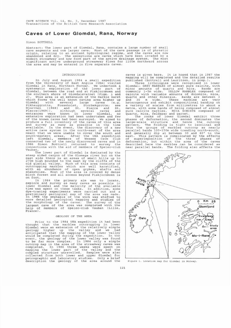
8/21/2019 BCRA 14-3-1987
http://slidepdf.com/reader/full/bcra-14-3-1987 33/52
C VE
SCIENCE
Vol. 14,
No.3 ,
December
1987
Transact ions
of the
Bri t i sh
Cave Research
Associa t ion
Caves
of Lower Glomdal Rana Norway
Simon BOTTRELL
Abstrac t : The lower
par t
of Glomdal, Rana, conta ins
a
la rge
number of
small
cave
segments
and one
l a rger
cave.
Most
of the
cave passage
i s
of
phrea t ic
or ig in , re la t ing to an
ancient hydrologica l
regime,
and
the caves
are now
abandoned
and
dry.
The
except ions
are caves which
have
been
invaded by
a
modern
streamway and
now form par t
of
the ac t ive drainage system. The most
s igni f i cant ac t ive underground
streamway
flows
for 1100m
northward across
the area and may
be
entered
in f ive separa te caves.
INTRODUCTION
In July and August
1984
a
small expedi t ion
from
the Univers i ty
of East Anglia
UEA)
vis i ted
Glomdal in
Rana,
Northern Norway. We undertook
a
sys temat ic
explorat ion of
the lower
par t of
Glomdal, between the road end a t
Fiskjornmoen
and
the southern
shore
of Glomda1svatnet Figs .
1
and
2). This
area i s
an
extension
of
the
marble kars t
which
forms
the well known caving area higher
up
G10mdal
wi th severa l
large
caves e. g.
Pikhauggrot te , Fossehole t ,
S torbekgrot t e ;
see
Hjorthen 1968) and St . P i e r r e
and
St .
Pier re 1969)) . Although severa l caves
and
entrances
were
known in lower Glomdal,
no
extensive explorat ion had been
undertaken
and
few
of the known caves
had
been
surveyed.
We
aimed
to
produce
a fu l l inventory
of
the caves
of t h i s
area
and
survey as many as
poss ib le
in
the
t ime
ava i lab le .
In the event , the discovery
of
a new
ac t ive cave system in the nor th-eas t of the
area
meant
tha t we
were
unable to cover
the
south
and
south-eas tern areas.
After the UE expedi t ion
l e f t
Glomdal, members of
Wessex
Cave Club
connected two
of the newly discovered caves and
in
1986 Simon Bot t re l l
re turned
to survey
the
connections with the
aid of
members of Speleo-club
Vauban
.
The lower
par t of
Glomda1 i s dominated by the
s teep
s ided
canyon of
the
Glomaga r iver but
on
the
eas t
s ide
there
i s an areas
of small h i l l s up to
270m
high
bounded to
the eas t
by
the
c l i f f s of
the
old
g lac i a l
val ley . Much of
t h i s
area
cons i s t s
of
outcropping marbles which are well
kars t i f i ed ,
with
an
abundance of
open
grykes, shaf t s
and
shakeholes . Most of the
area i s
covered
by
dense
bi rch fores t
and
a l l access
beyond
Fiskjornmoen
i s
on
foot .
In 1984
the
primary
aim was to locate,
explore
and
survey as many caves as poss ib le in
lower
Glomdal
and the ma jor i ty of the avai lab le
t ime
was
spent on these t asks .
In
addi t ion ,
some
dy e -
t racing
experiments
were car r i ed out
and a
prel iminary
geologica l map
of the area was
made.
In 1986 the emphasis of the work was sh i f t ed
to
more
deta i l ed
geologica l
mapping and
s tudies
of
the morphology
of the caves. The
survey
of the
l a rges t
cave
of the area
was completed wi
th the
help of members of Speleo-club Vauban Li l l e ,
Franc
e)
.
GEOLOGY OF
THE RE
Pr ior to the 1984 UE expedi t ion t
had
been
thought
tha t the marbles
outcropping in
lower
G10mdal
were an extension
of the r e l a t ive ly simple
geology higher up
the val ley and we had
ant ic ipa ted tha t the mapping
of
the lower val ley
would be completed during the
expedi t ion.
In
the
event ,
the geology
of the
lower
val ley
was
found
to be
far more
complex.
In 1984 only
a simple
outcrop
map
in the area of the streamway caves was
completed. In 1986 three weeks we r
e
spent on
mapping
the
lower
par t
of the
val ley
and
the
complex s t ruc ture unravel led. Samples were
also
col lec ted from
both
lower and upper Glomdal for
petrographic and
laboratory s tudies .
Only a
br ief
descr ip t ion
the geology
of the area
around the
121
caves i s given
here . I t
i s
hoped
tha t in 1987 the
mapping
wil l be completed
and the
deta i l ed
resu l t s
published Bot t re l l and Lauri tzen, in
prep.) .
Three l i tho logies
were
recognised in lower
Glomdal:
GREY
M RBLES
of almost pure ca lc i t e , with
minor
amounts of quar tz and
mica. Bands are
commonly
1- Sm wide. YELLOW M RBLES
composed of
ca lc i t e
with
var iable amounts of dolomite , mica,
quar tz and
other
minera ls .
Bands
are
between
3
and
30 m
wide. These
marbles
are very
heterogenous and
exhibi t composit ional
banding on
a
var ie ty of sca les from mill imetres
to
about
a
metre , with
some
bands of being composed of almost
pure
ca lc i t e marbles .
MIC SCHISTS
composed of
quartz, mica, feldspar
and
garnet .
The rocks of lower Glomdal exhib i t three
phases of deformation, the
second
dominates the
large-scale s t ruc ture
and hence
the outcrop
pat te rn . The
folding i s
t igh t
to i soc l ina l and
thus
the
groups
of marbles outcrop
as
near ly
para l l e l bands
100-lS0m wide t r ending nor th-south,
and general ly
dip
a t between
30 and
60·
to
the
eas t . This
pat te rn
i s
complicated
by the ef fec t s
of
superimposit ion
of
the three phases
of
deformation, but within the area of the caves
descr ibed
here
the
marbles
can be
considered as
near para l l e l
bands . The folding a lso af fec t s the
Figure
1. Location map
for Glomdal
in Norway.
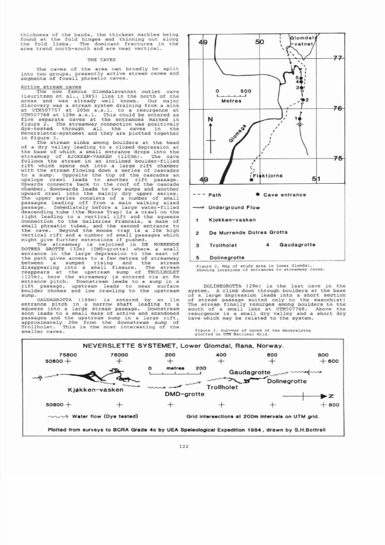
8/21/2019 BCRA 14-3-1987
http://slidepdf.com/reader/full/bcra-14-3-1987 34/52
thickness
of
the bands, the th ickes t
marbles
being
found a t the
fo ld
hinges and thinning
out
along
the fold l imbs.
The
dominant
f ractures
in
the
area t rend north-south and are near
ver t i ca l .
THE
CAVES
The caves of the area can broadly be sp l i t
in to
two groups, present ly ac t ive
stream caves and
segments
of
foss i l phrea t ic caves.
Active stream caves
The now famous
Glomdalsvatnet out let
cave
(Laur i t zen e t a l . 19 85) l i e s in the nor th of the
areas and was already wel
l
known.
Our
major
discovery
was
a
s tream system
draining from a
sink
a t
UTM50 7757 a t 205m
a . s . l .
to a resurgence a t
UTM507768 a t 129m
a . s . l . This
could be entered as
f ive separa te caves a t the entrances marked in
f igure 2.
The
streamway connect ion
was pos i t ive ly
dye- tes ted
through a l l
the
caves
in
the
Neverslet te-systemet and they are
plo t ted
together
in f igure 3.
The s tream sinks
among boulders
a t
the
head
of
a dry va
l l ey
leading to a
closed
depression a t
the
base
of which a small
entrance
drops in to
the
streamway of KJOKKEN VASKEN
(llOOm).
The cave
follows the stream
in
an inc l ined boulder - f i l l ed
r i f t
which
opens
out
in to
a large
r i f t
chamber
with the s tream
flowing
down a
ser ies
of cascades
to
a
sump.
Opposite
the top
of
the cascades an
upslope crawl
leads
to another
r i f t passage.
Upwards
connects
back
to the roof of the
cascade
chamber, downwards leads to
two sumps
and another
upward crawl into the
mainly
dry
upper se r i es .
The
upper se r i es consis ts of
a
number
of
small
passages leading off
from a
main
walking sized
passage. Immediately before a l a rge wa t e r - f i l l e d
descending tube ( the Moose
Trap)
i s a
crawl
on the
r igh t
leading
to
a
ver t i ca l r i f t and the squeeze
connect ion
to the
Gal ler ies Francais , a
maze of
small
phrea t ic tubes,
and the second
entrance to
the cave. Beyond the
moose
t r ap i s a 20m
high
ver t i ca l r i f t and a number of small passages which
might give fur ther extensions
i f
pushed.
The
streamway i s re jo ined
in DE
MURREN
DE
DOTRES GROTTE
(32m)
(DMD-grotte)
where
a
small
entrance
in the l a rge
depression
to the eas t of
the
path
gives
access
to
a
few metres of streamway
between a
sumped r i s ing and the s tream
disappear ing
in to
a small
f i ssure . The s tream
reappears
a t
the
upstream
sump of
TROLLHOLET
(125m) ,
here
the
streamwa
y i s
entered
via an
8m
entrance
pi tch .
Downstream leads to a sump in a
r i f t passage,
upstream
leads to near surface
boulder chokes and low crawling to the upstream
sump.
GAUDAGROTTA (188m) i s entered by an 11m
entrance
pi tch
in
a
narrow shaf t
leading
to
a
squeeze into
a
large stream passage. Downstream
soon leads to a small
maze
o f act ive
and
abandoned
passages and
the
upstream
sump in a large r i f t
approximately 20m
from the downstream sump
of
Trol lhole t . This
i s the most
in teres t ing
of the
smal ler caves.
o
500
• I I
Metres
N
t
I
I
/
,
,
ktjorna
Fi
1
•
Path
•
Cave entrance
Underground
Flow
Kjokken-vasken
2
De
Murrende
Dotres
Grotta
3
Trollholet
4
Gaudagrotte
5
Dolinegrotte
Figure
2. Map
of study area in
lower Glomdal,
showing
loc t ions o f
entrances
to streamway caves
DOLINEGROTTA
(29m) i s the
l a s t ca
ve
in the
system. A
climb
down
through
boulders a t the
base
of a
l a rge
depression
leads in to
a
shor t sec t ion
of
stream passage sui ted only to the masochist
The stream f ina l ly
resurges among boulders
to the
south of a small lake
a t
UTM507768. Above
the
resur
gence
i s a small dry val ley and a
shor t
dry
cave which may be re la ted to the
system.
Figure
3.
Surveys of caves of the Neverslette
plotted on
UT
National
Grid.
NEVERSLETTE
SYSTEMET, Lower Glomdal, Rana, Norway.
75800
50800 +
76000
+
K j ~ k k e n v a s k e n
50800
+
Water
flow
(Dye tested)
200
+
o
metrea
200
400
600
+
800
6 0 0
G a u d a g r o t t e ~ ?
~ ~
~
~ ~ . ~ ' D o l i n e g r o t t e
---' Trollholet
DMD-grotte
+
800
Grid Interaectlons
at
200m
Intervals on UTM grid.
Plotted from surveys to BCRA Grade
, ,C
y UEA Speleological Expedition 198' ', drawn by S.H.Bottrell
122
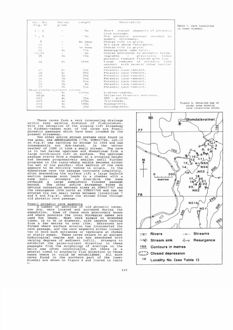
8/21/2019 BCRA 14-3-1987
http://slidepdf.com/reader/full/bcra-14-3-1987 35/52
Loc ~ . J r . : o .
0 1 g . 4 >
Survey
· ~ d e
5m
S h o r t
c h o ~ e d
s e q m e r l ~ s
of
r1hr-e A t l c
C.. J
.
v e ~ ~ s s 2
Ol d phrea t Ic ~ a s s a q p Invaderl
t
Jy
I
noder
n
w ~ y .
9
10
1 1
1-
4,-,
Choked r t
l r l g r y ~
Dry
c a v e ~ b o v e · e s ; L ~ r l r
Cho ke d r i
ft
In gr y le .
Anneksgrot
. ~ ?
(see
t e
' :
t.)
.
1:: , 1 ·4
15
16
4rn deep
3m
~ , m deep
T m
:=Jm
3
r
)m
C h C ) ~
e n t r c n \ c ~ ~ s to phr p a t 1
r
t U \ I : - ~ S
I S I . J r o t t r ~ - p V l r ~ : : : , I , l
n o \ ' l n
phrea t i c r ~ l n n a n f l c)()r ed w t h I c e .
~ r g e
remrlant
o f
p h r e ~ t l c
l b ~
n e t ~ J o r ~ with
s e v e r ~ l ( l t h e r
s m ~ l l e r
~ n t r ~ n c e 5 .
I'le'/E'r
1
t t e l n ~ t. C
i.:lVr:.:s :
22m
95m
2
r
) m
20m
I'IS1
4c 1.1.
1
)
010
Ph r eat ic
- e m n ~ n t : . .
F'hre lt .
c: cavE'
r - e m n ~ r ) t .
F hreC\t lc
c<,J.vp
r emn,3n t.
Ph r e a t i
c:
cave
r
emnant..
F'hre.:.;..tir::
c:
. . : ~
\'
. . ~
r emn-3n
t
F·
h
rea :.ic
cavE.'
r'
emnant
F h r ea .t C
V r : - : > rE'mn. :
\nt .
o k k e n - v a s k e
NS1A
4c
G ~ l l e r - F r ~ n c 2 l s ~ n t r ~ n c ~ .
N:3
4,-
tJ
33
c
11:;4·
1-c:
r·j·35
4c:
:;:2
m
1
::5
18: 3.0
29m
OMD -
qro t t e
.
Tro l
lh
o l e t .
n·.3-ud
ag
r
o t t.
a .
Dol
i roegr
o t t a
.
These
caves form a very in te res t ing drainage
with i n
easy walking
d i s t anc e of
Fiskjornmoen.
wi
th
the excep t ion o f the s lop ing rift
streamway
in Kjokken-vasken most of
the caves
are
fo ss i l
phrea t ic passages which have
been
invaded by the
present streamwa
y .
Two
othe r ac t ive
st ream
systems were found
in
the
a rea , one ANNEKSGROTTE (77m, UTM507766,
loc .12
on Fig .4 ) was ca r ry ing
no
st ream in 19
84
and was
consequently not
dye- te s t ed .
In the wetter
w
ea the r
of 1986 it
took
a
smal l s t ream.
The cave
i s
in
two
ha l
v
es
upst ream
and downstream from
a
la rge nor th -sou th rift
on
sur face .
The
upst ream
passage s t a r t s
from a
chamber
a t a s tooping
he igh t
and
becomes progress ive ly smal le r un t i l fur ther
progress in the
r azor - sha rp
marble becomes e i t he r
too
wet
or too painfu l ; t h i s
sec t ion
of the
ca
ve
appears to be
en t i r e l y v
adose i n o r ig in .
In the
downstream cave the passage con t r a s t s completel
y ,
af t e r
descending the surface rift
a
l a rge keyhole
sec t ion
passage
soon
leads
to
a chamber wi t h a
sump pool .
Attempts t o f r ee -dive
the sump
revealed a
la rge completely
f looded passage
beyond.
The o
ther
a c t i ve
streamwa
y f o
rms an
ob
v ious
connec t ion between s inks
a t UTM507767
and
the resurgence 100m nor th a t UTM507768 and
can
be
en te red
via
two smal l caves
between
( loca l i t i e s 7
and
8
and Fig. 4) , where
the
st ream
flows through
old
phrea t i c cave
passage .
Foss i l phrea t i c ca
ve
segments
77
+
metres
76
Rivers
~ ?
Stream sink
Table
1.
Cave lo cal i t i e s
in lower Glomdal .
Figure 4. Detai l
ed
map of
study area showing
cave
l ocal i t i e s noted,
16
17 , 20
1 ~ ~ § t 21
19 ..22
23.
NS2
7
Streams
q V
Resurgence
A
number of sec t ions of old phrea t i c ca
v
es ,
now
dry, were l oca ted and surveyed
during the
exped i t ion . Some of these w
e re
previous ly known
and where
poss ib le
the loca l Norwegian names are
used for these . Most were
s ingle or
branched
tubes , 1m to 3m in
diameter , with l eng ths v arying
from a few metres
to over 15 0
m.
Entrances are
formed
w
here su r face e ros i
o n
has i n t e r sec t ed the
cave passage, and the cave segments e i t he r connect
two
or
more such en t rances or
t e rmina te a t
chokes
or s t a t i c
sumps.
These caves r e l a t e to an ancient
hydro log ica l
regime
and are now abandoned with
varying
degrees of sediment
i n f i l l .
Attempts to
es tab l i sh the
pa leo-cur rent d i r ec t i on i n
these
passages from the morphology of sca l l o
p s
on
the
wal l s was
of ten
inconclus ive , bu t
t he re i s
a
genera l t r end to southe r ly flow d i r ec t i on i n
those
cases . ,here it could be es tabl i shed . All such
caves
found in
the no r the rn
pa r t
of the lower
Glomdal are
sho
wn on
f igure
4 and l i s t e d i n t ab l e
1 .
150
Contours
in
metres
G::)
Closed depression
10
Locality
No.
(see Table 1)
123
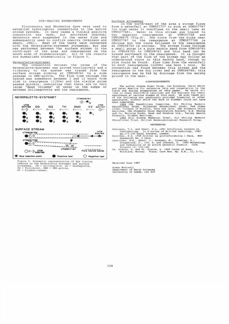
8/21/2019 BCRA 14-3-1987
http://slidepdf.com/reader/full/bcra-14-3-1987 36/52
DYE-TRACING EXPERIMENTS
Fluoresce in and
Rhodamine dyes were used to
es tabl i sh
hydrologica l
connect ions in
the
act ive
stream systems.
In
many
cases
a vis ib le pos i t ive
conne
ct ion
wa
s made, but ac t i vated charcoal
detec tors were suspended
in
the
water f low
and
subsequently
used
to confirm
resu l t s
(Atkinson
and
Smart, 1981).
Mo
s t of
the
t e s t s were concerned
wi th the Neverslet te-systemet streamway, but one
w
as performed
bet
w
een
the
surface s
tream
in
the
nor th
-eas t
of the area and
resurgences
on
the
s outh s ide
of
Glomdalsvatnet. All of
the
resu l t s
are
summarised
schemat i ca l ly
in f igure
5.
Neverslet te-systemet
The
connect ion between the
caves
of t he
Neverslet te -systemet was proved conclusively
and
a
t r i bu t a ry
to
the
system was t raced
from the
surface stream
s inking
a t
UTM508761 to a
s ide
passage in DMD-grotte. The
flow t ime
through
the
system
was
somewhere between 2
and
12 hours from
sink to resurgence 11 00m)
and the
v is ib le
pulse
passed quickly,
indica t ing
tha t there are no very
large dead
volumes of wa te r
in the
sumps or
between Dol inegrro t te
and the
resurgence.
NEVERSLETTE-SYSTEMET
UTM508761
S ~ 3
UTM
UTM
507788
DG GG
TH
DMD
KV
507757
.1
.1 .1 .1 .1
1
.2 .2 .2 .2
2
• 3
3
3 3
3
SURFACE STREAM
UTMII087811
. ~ ~ ' ~ ~ ' ~ ' ~ '
U T M : o : ; ~ . , L
. 7 -b
: : i
~ r ' - J J I J J
UTM
, , I
J
O ~ I I ~ V ~
UTM1I07787
P u r ~ : ~ r b l e band.
* Dya Injection point • Po.lllve te.t o Negatlv. t• •
Figure
5 . Schematic
representat ion
of dye tracing
resul ts
in
the
Neverslette
Systemet and
surface
streamway. G
=
Dolinegrotte, GG
= Gaudagrot te ,
TH Trollholet , M
=
M -
grot te ,
KV
= Kjokken-vasken.
Surface streamway
In
the
nor th-eas t of the
area
a
stream
f lows
from a water fa l l
a t
UTM507757 to sink
a t
UTM50 7767
in high wa te r
it
overflows to
the
small lake a t
UTM507768) .
Water in t h i s s tream was t raced to
two
separa te resurgences
a t
UTM507768 and
UTM508679 Fig .4) . One
route
from the
s inks
near
UTM507767 to
the
resurgence a t UTM5077768
i s
obvious but the route followed
to
the
resurgence
a t UTM508769 i s unclear .
The stream f lows through
a
small
gorge
in
a
pure marble
band
from
UTM508765
to UTM508765 to UTM509763
and
t h i s
band
can be
t raced northward to
the
resurgence. I t i s thought
tha t
par t
of the flow of the
s tream
may
follow
an
underground
route
in t h i s
marble band, though
no
s
in
k could be found. Flow t ime from
the
water fa l l
to both resurgences (1200m) was bout 1 hour.
No
connect ion
was found between
t h i s s tream
and the
resurgence in
the
dry
r iver bed
a t
UTM506768;
t h i s
resurgence may be fed by drainage from the marshy
ground to the west .
ACKNOWLEDGEMENTS
The au thor thanks Nigel Crisp, Ian Kitching, Chris Smith
and K
aren
Beatt ie for extensive
help
and cooperation in
the
f ield
and
during
preparation of
th is paper . We would
a l l
l ike
to thank Stein - Erik
Lauritzen
and Tim Atkinson for
the i r
ass is tance
at
various stages of
this
work. We
also thank
a l l
of
the following who generously
provided f inancial or other
assis tance,
without
which
the
work
in
Glomdal
could
not
have
been completed.
1984 UEA Expeditions Committee, Sir
Phil l ip
Reckitt
Educational
Trust, Gilchr is t
Educational
Trust,
Fed
Olsen
Lines, Colm
ans
of
Norwich,
Tate
and
Lyle,
UEA
Student s Uni
on
Se r vices,
UEA
Students
Union
Exploration
Society,
R.E .
Thorns
and Co, Morning Foods, Read and Woodrow Ltd., Farley Health
Products, Trident Maritime.
1986
Bil l
Bishop Memorial Trust, Sir
Phil l ip
Reckitt
Educational Trust, Bri t ish Geomorphological Research Group .
REFERENCES
A
tkinson,
T.C.
and
Smart, P.L. 1981
Art i f ic ia l t racers in
hydrogeology . In A
survey of
Bri t ish
hydrology,
1980
pp.173 - 190 Royal Society, London .
Hjorthen,
P.G. 1968 Grotter og grot teforskning i Rana.
NGU
Smaskrif t No. 9 Oslo .
Lauri tzen S -E . Abbot
J .
, Arnesen R. Cross ley Go
Grepperund , D
. ,
Ive,
A
and Johnson, S. 1985 Morphology
and
hydraul ic s
o f an ac t i ve phreat ic
conduit .
Cave
Science 12;
139-146
.
St . P ierre D. and
St . Pierre
S.
1969
Cave
s
of
Rana
Nordland, Norway . Trans. Cave Res. Gp . G.B., 11; 1-71.
Recei ved
June
1987
Simon Bo tt re l l
Department
of Earth Sciences
University
of Leeds, LS2 9JT
124

8/21/2019 BCRA 14-3-1987
http://slidepdf.com/reader/full/bcra-14-3-1987 37/52
CAVE SCIENCE Vo l . 14,
No.3 ,
December 1987
Transact ions of
the
Bri t i sh Cave
Research
Associat ion
aves and Mi
nes of
Hawkstone
Park
Salop
Terry MIDDLETON
Abstract
:
Hawkstone
Park
contains
a
number
of impressive outcrops of
Tr iass ic
sandstone which
have, over
the years
, been worked
by
man resu l t ing
in
the product ion
of
both
caves
and mines.
These
workings have been
described and where
accessible , surveyed
and a summary of the his tor ica l
and
geological
se t t i ng of the s i t e has been made .
Set within some of the most picturesque
scenery
in
Shropshire
Plain ,
Hawkstone
Park
provides
a fascinat ing and indeed memorable
local i
ty for a
v i s i t .
I t i s of in te r es t to the
speleologi
s t because
of the number of caves which
l i e within i t s boundary . Unlike the natural
caverns of kars t areas, the caves of
the
Park
occur
in
sandstone and most
of them
are
man-made
having
been constructed dur ing the 18th century
purely for the enter tainment of vis i to r s . The
Park
also
contains
to a l imi ted ex ten t
evidence
of
mine working
and
t h i s
together with the
caves
forms the
basis
of th i s
report .
The
Park
, which provides a superb
set t ing
for
a golf course, i s located some l lkm
north - north - eas t of Shrewsbury and km
west - north-west of
the
vi l lage of Hodnet and can
be approached from e i ther
the
A49 or
the A53.
Three h i l l s and an
escarpment
r ise above and
provide a
sharp
cont ras t to the ro l l ing ter ra in of
the
golf
course
and these
are
known respect ively
as Grotto
Hil l ,
Red Castle
Hil l , Elys i
an
Hil l and the Terrace. At the i r
highest point ,
the
wooded slopes r i se to a
maximum elevat ion of 208m a t a spot marked by the
Obeli
s k on t
he
Terrace . All
of
the land wi
th in
the
Park i s private
and anyone wi s hing to
v i s i t
the loca l i ty must
f i r s t
obtain permission
from
the
manager
of the
Hawkstone
Park
Hotel .
GEOLOGY
The rocks of the
Park
are Tria s s ic in age and
comprise, in chronological orser ,
red
Bunter
Upper
Mottled Sandstone,
buff
- co l oured Lower Keuper
Sandstone local ly
known as
Grinshi l l Sandstone
and Keuper Waterstones Pocock and Wray,
1925).
Under modern
s t r a t ig raph ica l nomenclature the
Grotto
Hill viewed from the Red
Castle area. Note
the
path
which traverses the base of the
c l i f fs and
the ruined arch which
is
s i tuated by
the
summit
at
the
southern
end of
the
hi l l . The
wooded slopes of
the
Terrace can
e seen on
the
r ight
hand side
of the photograph.
25
Lower Keuper
Sandstone
and the
Bunter
Upper
Mottled Sandstone
form
the uppermost uni ts of
the
Sherwood
Sandstone
Group
whilst
the Keuper
Waters
tones form the
basal
bed of the Mercia
Mudstone
Group
Warrington
e t
a l
, 1980) . Good
c l i f f sect ions of a l l three l i tho logies are
displayed
a t
Hawkstone. The sandstone uni t s ,
which are
extensively
cross - bedded , dip gent ly
a t
an
angle of 6 degrees
in
a north north-wester ly
di rec t ion .
In
consequence ,
the
older , mainly red
sandstone
s
outcrop
a t
the southern
end
of the
Terrace and a t
Elysian
Hil l
wh i
ls t the
over lying
Grinsh i l l
sandstones,
of
which
over
45m a re
exposed,
are seen a t the northern
end
of the
Terrace and a t
Grotto
Hil l . Red Castle Hil l
comprises a small out l ie r of Grinsh i l l s andstone
rest ing
upon the red sandstones
which
continue
beneath the undulat ing land
scape of
the
golf
course. A
good
sect ion of Keuper Waterstones i s
exposed i n the ravine a t
SJ582293
.
Fa u
l t s bound
the
north -
west
and north -
eas t e r ly edges
of Grotto
Hil l and
the
Terrace
see
Bri t i sh Geological
Survey 1: 63360
sheet
138 Wem;
1967
and explanatory
memoir Pocock and Wray
1925).
The Grinshi l l
sandstone, which i s
local ly
a n important building
stone
in
the
area, contains large numbers of
small
res is tant
c rys ta l l in
e nudule s
whi
c h
were
desc r
ibed
by Pocock and Wray as nests of b a r i t e crys ta l s .
However
the nature
of
these
crys t a l s
or
pseudomorphs?) i s d i f f i cu l t to confirm
without
microscopic
or
chemical analysis . These nodules
are
also
pre
s en t , though less abundant, in some
of
the outcrops of the under lying red sandstones .
Both sands tones contain subangu l ar grains and in
several areas
the
s i l i ceous matrix of the bedrock
has
been replaced by
a
calcareou
s cement.
The
presence of the
crystal l ine
nodules, the
var ia t ions in colour of the sandstone,
together

8/21/2019 BCRA 14-3-1987
http://slidepdf.com/reader/full/bcra-14-3-1987 38/52
with the
f luctuat
i ng nature
of
the cementing
mater ia l suggest
that
the
sediments
/ rocks have
been subjected to both penecontemporaneous and
post-diagenet ic changes.
Green
copper
ores of low
grade
may be found
in the
upper
uni t s of the Grinshi l l sandstone.
These have
been
named
as
malachi te
by
previous
authors (Murchison, 1839; Pocock and Wray,
1925;
Dewey and Eastwood 1925; Carlon, 1981)
however
t
should
be
noted
that
dur ing recent f i e ld t e s t s the
ores
f a i l ed
to
show
any
react ion to
d i lu t e
hydrochloric
acid No
deta i l ed chemical
examination
of
the ores
i s known to
have
been
carr ied
out.
Blue copper
minerals , pos s ib ly
azur i t e occur loca l ly in very small amounts. The
ores tend to be found impregnated between s l igh t ly
coarser
uni t s within the
cross-bedding. The
mineral izat ion does not
appear
to be
associated
with, or be loca l i sed by,
fau l t s t ructures .
THE MINES
Although the
copper
ores are of low grade
there
i s
some evidence to
suggest
t ha t they may
have
been mined or
that
t r i a l s were car r ied
out .
Many au tho r i t i es have
suggested
that
Hawkstone
Grotto (SJ.573297)
was a Roman copper mine
(Watkin,
1879;
Kenyon, 1892) and i f
so
t
i s
the
only
mine
a lb ie t
modified subsequent ly,
t ha t
is
accessible in the
Park
today.
I t
has also been
suggested
that
the Roman v i l l a
found
a t Weston
could
have
housed a mine of f i c i a l (Kenyon, 1892) .
However
these
ten tat ive
connect ions
st ll
have to
be proved . Never t heless there i s
ample
evidence
of
the
Roman
occupat ion
in
the surrounding area
.
Roman coins and
bronze implements have
been found
in the r u ins of the Red Castle and more Roman
ar tefacts have been
discovered a t the
h i l l
f
or t of
57
Bury
Wall.s
which l i e s 2km to the south
(Watkin,
1879; Kenyon, 1892). A hammer pick of possible
Roman or ig in has been
discovered
a t
Hawkstone
(Davies, 1935) and the Roman road
connecting
Wroxeter
(Viroconium) with Chester (Deva) was
described in the Victo r ia County History (1908) as
climbing the western extremity of
Hawkstone
r idge ' . There i s also plenty of evidence to
confirm that
the Romans were
ext rac t ing
lead
from areas
nearby
including
Shelve
H il l and the
Stiperstones .
Pigs of
lead
bear ing the
inscr ip t ion
IMP. HADRIANI. AVG (Imperatoris
Hadriani
Augusti) have been found in
the
Snai lbeach area of the
St ipers tones j u s t
south of
Shrewbury
(Davies, 1935).
The workings a t
Llanymynech
Hil l (Adams, 1970),
which
are also
thought to
have
been worked by the Romans
for
e i ther
lead or copper, are l ikened
in
the Victo r ia
County History (1908) to those a t Hawkstone.
However
the
proposed
s imi l a r i ty does seem a l i t t l e
dubious The grot to a t
Hawkstone
was
subsequent ly
enlarged
for
recrea t iona l purposes
and as a
res
u
lt
for the
purpose
of th i s account i t s fu l l
descr ipt ion
has been included in the
sect ion
on
caves.
Both
Murchison (1839)
and subsequent ly
Carlon
(1981)
make reference to a shaf t on the Terrace .
The shaf t is said to be located a t SJ. 576295 and
was
described
as being
1.5m
in
diameter
and
capped
by an iron gr i l l e with sandy spoi l nearby. This
area
can be reached by
following the footpath
up
the h i l l from C7 and C8 to the Terrace. The shaf t
should be located in the area immediately north
eas t of the
junct ion
of th i s footpath
with the
main path along
the top
of the
Terrace
. This
region
i s covered
with rhododendron s a nd the
undergrowth i s so
dense
t ha t a person could walk
d i rec t ly over
the
g r i l l e
on
the shaf t without
Grotto
Hili
T H E
C VES
OF
WKS
TONE
P RK
SJ5729
29
Key: .... l i f f
S t
oo
p s
lo p
Ro
od
< o _ Fo o t path / ... Wood bou nd.r v
57
126
N
.....
/
_ i
o Bu ild ing
• C
ave
29
Figure 1. Map showing the
locat ion
of the caves
found
within the
boundary
of
Hawkstone
Park.
(Clif f
detai ls taken
and
enlarged
from the 1:10560
Ordnance Survey map SJ52NE.
Cave
locat ions
mapped by
author
-
May 1987).

8/21/2019 BCRA 14-3-1987
http://slidepdf.com/reader/full/bcra-14-3-1987 39/52
real i s ing i t
A search for the shaf t during t h i s
survey proved f ru i t l e s s . Disturbed
ground
composed
of
loose sandy mounds and tunnels
cover ing
an area of approximately 180 square
metres was
found
wi th in t h i s
region of
woodland
close to the
boundary
with the adjacent
f i e ld .
However t h i s
dis turbed area
appeared
to be no more
than an extensive
badger s
set The shaf t was
l a s t seen
i n
1952 (Carlon,
1981) and
t
i s
unl ike ly to
be
re loca ted unt i l
the rhododendron
bushes
are
thinned.
More workings occur j u s t beyond
the
boundary
of the Park
a t SJ.587292 (Pocock and Wray, 1925;
Carlon,
1981). The
workings included a small
shaf t
3m
deep connected to an 2 . 4m
level
dr iven
to
the
south
eas t
which in turn l inked to a 6m level
running
south - south-west
to i n t e r sec t
the slopes
of the Terrace. The workings, which were
i n f i l l e d
in
1977,
were sa id to
contain deposi ts of
azur i t e
and malachite .
These 2
sets
of workings
(SJ.576295
and
587292), both
of
which are located on the
Terrace,
seem to
have
been l i t t l e more than t r i a l s . I t
i s
di f f i cu l t
to
date
them,
but
they may
have been
excavated dur ing the 17th or ear ly 18th century
pr ior to the purchase
of
the land
by
the Hil l
family in 1737 (Carlon, 1981). Documentary
evidence of the
dates of
the mining a t nearby
s i t e s
may
be
re levant to
th i s
quest ion.
Sources
s i ed by Warrington (1980)
indicate that
mining
occurred
a t
Weston
and around
Redcast le before
1740,
and that the
par tnership
was formed
to mine
in the townships of Weston-under-Redcastle and
Wixhill in 1697. This ac t iv i ty probably
took
place
a t the
s i te s
noted
by Dewey
and Eastwood
(1925) and
Pocock and
Wray
(1925) between
1
and
2.5km south - west of
Red
Castle
Hil l .
Some
working
a t
wixhi l l
also took
place
dur ing the
mid-19th
century
(Pocock and Wray, 1925).
Carlon
(1981)
also
re fe r red
to leases being
granted in 1897 and
The
arch C3) and the
footpath
at the base
of Cli f f s on Grotto Hill .
1698
for
mining
a t Wixhi l l .
As noted
by
Warrington
(1980),
the documentary
evidence
of
working
of
non-fer rous
ore deposi ts
in
Cheshire
and
nor th Shropshire
in the l a t e
1690 s
contrasts
with the
lack
of such evidence
before
tha t time
and i s
consonant
with the
development
of
i n t e res t
in them af te r the passing of the Mines Royal
Acts.
I t would, therefore , seem reasonable to suggest
tha t
the
mining t r i a l s
found
within
Hawkstone
Park
were dr iven
a t
the
same time
as those of s imi lar
loca l i t i e s
in
the
vicin i ty .
THE CAVES
Much of the landscaping of the
Park
was
car r ied
out dur ing the
18th century by i t s owner
Sir Rowland
Hil l
(Oswald, 1958).
During
t h i s
per iod a number of
cu r io s i t i es
were contructed for
the
benefi t
of
vis i to r s including the Obelisk, the
White
Tower,
a
l ion ' s
den complete with
stone
l ion,
a
hermitage and
severa l caves and
rock
shel ters .
A t o t a l of 11 such caves can
be
found
a t Hawkstone ( f igure 1) and although a l l but
one
of
them
are very
smal l , they
are nevertheless of
i n t e res t as tokens
of the
lengths
to
which the
landowner
was
prepared to
go
to add i n t e res t to
his
Park.
The
caves
can be subdivided
in to
3
categor ies :
1) Former mine
workings
t ha t
were
extended or
enlarged dur ing the
18th
century.
2) Tunnels not associa ted with mining tha t
were constructed
dur ing the
18th
century.
3) Natural alcoves or
recesses in
the
cl i f f s .
These natura l alcoves have been included in
th is
repor t
because
they were named as
caves in
the
old tour i s t guides to the Park and were
mentioned in t he i r i t i ne ra ry . Typical excursions
are
descr ibed
by Leach,1891; Davies, 1894; Haslam,
1985; and in the
Hawkstone
Handbook
for
~ 9 3 8 The
s i t e of each cave i s
shown
on the loca t ion map and
plans of the
larger
systems ( f igures 2 and 3) have
been included with t h i s ar t ic le . A number
of
caves are marked
on the
1: 10560 Ordnance Survey
map (SJ52NE). All are descr ibed below:
C
(SJ.57142940):
s i tua ted
a t
the
western
end
of
the obvious
eas t /wes t
t rending
gul ley on
Red
Castle
Hil l .
I t
comprises
a s ingle
curved
passage
12m in length ( f igure 2) which l inks the gul ley
with the
west-south-west
face of Red Castle Hi l l .
The
tunnel , which is cut
through
red sandstone, i s
0.8m wide and
1.8m
high and
bears a mu l t i tude of
pick
marks.
I t i s also gent ly
incl ined
to the
west
and t rends in an eas t /wes t di rec t ion .
C2
(SJ.57082963): located
in
a small
i so lated
pi l l a r
of
red sandstone
a t
the northern edge
of
the
r idge
of Red Castle Hil l .
I t i s
j u s t 5m long
and
i s S-
shaped in
plan
with
an entrance a t
e i ther
end. I t t rends
in
a nor th west/south
eas t
di rec t ion . The passage
is 1.8m
in
height , 0.8m
in
width
and
is
man - made (see f igure 2) .
C3
(SJ.57252970): a shor t
man-made
arch
5m in
length
with benches
hewn out
of the rock
on
e i ther
s i
de.
I t can
be entered
by
fo l
l owing
the
path
which sk i r t s the south west facing c l i f f of Grot to
Hil l (see
photograph
1) .
The
arch i s 1.2m wide,
2m high and has been driven through a
buff - coloured sandstone .
C4
(SJ.57232985): located a t the northern end
of
Grotto Hil l
and
has 2 entrances.
I t i s bes t
entered
from the
narrow
ravine which cuts
through
the dip slope of the
escarpment. The
cave i s
man- made and l inks
in
an
eas t /wes t
di rec t ion and
i s 18.5m
long. The low
entrance
s i t ed in the
ravine leads to a small
ci rcu lar
chamber with a
cent ra l
pi l l a r and window .
From
the
chamber,
the
passage
becomes
gradual ly lower
and
f ina l ly
emerges
in to
dayl igh t
(see
f igure 2) .
The
l a t t e r
par t of the cave i s wet with much mud on the
f loor .
127

8/21/2019 BCRA 14-3-1987
http://slidepdf.com/reader/full/bcra-14-3-1987 40/52
Hawkstone Caves
Ravine entrance
HAWKSTONE
GROTTO,
Plan
SALOP.
N
C8
SJ
57 9 969
BeRA Grade 50
PL N
-'/
Iab
~
Mag
N
o
10
metres
Key
/
Steep
cliff
Window
Entrance
Pil lar
o
Skylight
•
Blocked skylight
Surface arch
Joint
Surveyed by O John , D. Luke , T.Middleton , February 1987 .
C5
- Hawkstone
Grotto
SJ.57302970):
s i t ua t ed a t the summit of
Grot to
Hil l ,
it can be reached by e i t he r
proceeding
along the rav ine
to i t s
southern
end
or
by fol lowing one of the pa ths up the d ip s lope o f
the escarpment . The
cave
has 4 en t rances
and i s
by fa r the l a rges t
sys tem
in the Park
and
a
de ta i l ed survey
i s
presented he re in
( f igure 3) .
Deposi ts of green
and
a
little
blue
copper
ore
can
be
seen impregnated in the
bedded
buf f -co loured
sandstone
un i t s .
The
passage
which
leads
i n to
the
system from the r avine
i s
2m high and m wide and
t r ends in a nor th wes t / south eas te r ly d i r ec t i on
( f igure
3) .
Oswald 1958) s t a t ed t ha t t h i s
passage was cons t ruc ted
for
Si r Richard
Hi l l to
connect with the
main
pa r t of the G ro t to . The
r e s t of the cave appears to be much olde r
than
t h i s passage and, as a l ready
ment ioned,
a number
of au tho r i t i e s have
suggested
t ha t
it
may have
or ig ina ted
as
a Roman Copper
Mine.
The cave
was
v i s i t ed by
Dr
Johnson during h i s
t r ave l s
Oswald,
1958) .
Soon a f t e r enter ing the cave from the rav ine
the
former
posi t ion of the doorway
can be
seen
cut
i n to the passage
wal l s .
Although
the p le thora of
pick marks in the
passage
tend
to
obscure the
f i ne r geologica l d e t a i l s , a number of near
ve r t i c a l
sediment
f i l l e d f i s su re s can
be
seen on
route to the Labyrinth .
The
pos i t i on
and
t r end
of
these
j o i n t s
have been
shown on
f igure
3.
Small
amounts of water
i n f i l t r a t e
down the penult imate
j o i n t j u s t pr io r
to
the junc t ion with the f i r s t
chamber.
A
hole
on the r i gh t l eads
i n to
the f i r s t
128
20
. - ~
\
C4
Figure 2. Surveys
of
some of
the
smal ler caves
found
with in
the
Park.
(Detai ls recorded by
author
January - May
1987).
TCM Figure
chamber ( ' A
on
f igure 3) which i s approximately
c i r cu l a r and has a diameter of 5.6m. The chamber
con ta ins 2 main p i l l a r s and 2
skyl ight s
one of
which i s blocked. These
support
p i l l a r s vary in
s i ze throughout the cave. However, fo r c l a r i t y ,
they have
been shown on the
survey
as
being
equa l - s i zed. At
the no r th -wes te rn
s ide of the
chamber
l i e s
a
shor t s emi -c i r cula r passage around
a fur ther p i l l a r . The so l id sandstone a t the
en t rance to t h i s
sec t ion
has been carved
to
resemble
a
s tone arch.
At
the
f a r
s ide of
t:1e
chamber a passage leads in to the
Labyrin th
whi l s t
the or i g i na l en t rance passage continues i n to a
second c i r cu l a r chamber ( . B •
on f igure
3) with a
diameter
of
7.
3m.
t
has 4 support
p i l l a r s and
one of these in pa r t i cu l a r has been beau t i fu l l y
carved and f lu ted . Out of the 3
skyl ight s pre sent
only
1 i s
open.
At the no r the rn end of the
chamber a shor t passage l eads
out
i n to dayl ight a t
the
edge
of the
c l i f f
( take ca r e ) . The chamber
a l so
has a
smal l a lcove on its western
s ide . A
passage continues from
the
southern
end of the
chamber i n to the Labyrin th .
The Labyrin th i s a
most
impressive
cavern
with
sha f t s
of
l i gh t ente r ing
from
skyl ight s and
windows
a t
the western end. t
i s
28m in l ength
and 9m in width and con ta ins
seve ra l
rock p i l l a r s .
At
the western
end
a passage l eads ou t onto the
edge
of
the
escarpment
and
the pa th may
be
fol lowed to a carved viewing area .
In
seve ra l
p laces the uneven wal ls of the
Labyrin th
appear to
have
been coated with a l aye r of
green
pa in t
( a l so
noted by Jones,
1974) . At the
southern
end of
the

8/21/2019 BCRA 14-3-1987
http://slidepdf.com/reader/full/bcra-14-3-1987 41/52
The southern entrance
area
o f
Hawkstone ro t to Note the
remains o f a roo f on the
back
w a l l s .
cavern a number of route s l ead through o ld
doorways i n to the Grotto . The fol lowing
descr ip t ion
of
the
s i t e appeared
in
The County
Sea ts of Shropsh i re ' (1891);
the v i s i t o r i s in troduced
to
the magnif icent
Gro t to ,
a vas t
subterranean
cave,
in the midst
of
which i s a spac ious recess f an t a s t i c a l l y
i n l a i d
with
a grea t va r i e ty of s he l l s , f o s s i l s
and othe r cur ious pe t r i f ac t i ons
Or i g i na l l y
the windows of the
Grot to were
f i l l e d
with
painted g la s s , unfor tuna te ly however,
none
of
t h i s remains today. During the 2nd
World
War the Park
was
u t i l i z ed f i r s t by an American
mi l i
t a ry camp, then by a German Prisoner of War
camp
and
f i na l l y by Br i t i s h t roops wa i t ing
for
demobi l iza t ion
.
During
t h i s
per iod
much
of
the
ornamentat ion in the
Grotto
was
destroyed
(J .Jones
pers comm .
) . Nevertheless
some of the decora t ions
still remain and they are
be s t
d isp layed a t the
eas tern end
of
the
Grot to
where numerous s he l l s ,
mainly
l amel l ib ranchs
and
gastropods,
have been
s e t in a cement /plas ter
matr ix
toge the r
with
much
furnace s lag . The remains
of
a t i l e d roof can be
seen in places . The
ru ined arch
which s tands
a t
the top of Grotto Hi l l (ye t another
fo l ly)
l i e s
The
Labyr
i
nth
in Hawkstone
rotto
129
d i r ec t l y above the main passage
which l inks
the
Labyr inth
with the Gro t to . The westernmost
passage
l inking
the Labyrin th with the
Grot to has
a beau t i fu l l y arched roof and it w
as
in t h i s
area
t ha t ba t s ,
a t
one t ime, were qui te common .
Un
for tuna te ly
none o f the
cave
s in the Park
appear
to be used
by the
ba t s today.
Most
of
the
ex i s t i ng cave fauna can be found in
the
blocked
skyl ight s and
the
ca ve spide r
(Meta
menardi)
and
the
Hera ld Moth
(Scoliopteryx
l i ba t r ix ) are
the
most not iceable
spec ie s .
The
Gr o t to may ha
ve
been occupied by a hermit
pr io r to the
18th
cen tu ry and, i f so t h i s could
have
been
the
rea s on why
the
Hi l l family l a t e r had
an
a r t i f i c i a l hermitage complete w ith au t omaton (a
pap ie r
mac
he f igure worked by le v
e r s )
b u i l t with in
the Park.
C6
-
The
Retreat
(SJ. 57372973): a natura l alcove located
a t
the
base of the c l i f f s immediately ad jacen t
to
the
foo tpa th which leads up onto the Terrace
( f igure
1) . t
i s
found
in
a
buff
-
coloured sandstone and
i s only
m wide
and 4m high.
t
i s
i
ncluded in
t h i s r epor t because it was desc r ibed as a cave in
the i t i n e r a r i e s
of
the
Vi c t o r i an
t ou r i s t guides .
A f i s sur e i n f i l l e d with a mottled ca lca reous
f ine
-
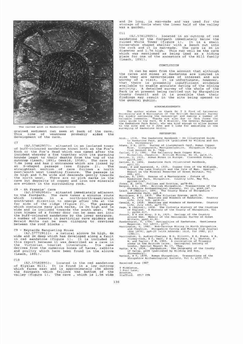
8/21/2019 BCRA 14-3-1987
http://slidepdf.com/reader/full/bcra-14-3-1987 42/52
The carved
arch
in
Hawkstone
Grot to
grained
sediment
can seen
This
l ine
of
weakness
development
of
the cave .
C7
a t
back
probably
of
the
aided
cave.
the
(SJ.5 7462957): s i tua ted
in
an i so la ted tower
of
buff - coloured sandstone known both as the Fox s
Knob
or
the
Fox s
Head which was named af te r the
inc ident whereby
a
fox
together with
i t s
pursuing
hounds
leapt
to
t he i r
deaths
from
the
top of
the
outcrop (Leach, 1891; Oswald, 1958) .
The
cave i s
7.8m long and
has
2 entrances which are l inked by
an
S-shaped passage
(see f igure
2) . The
s t r a igh tes t
sec t ion
of cave
follows a
north
eas t / south west
t rending
f i ssure . The passage
i s
2m high
and 0.9 m wide and
descends
gent ly towards
the
nor th
west. There are
no
pick
marks in the
cave but depos i t s
of
copper
and
i ron
ore
minerals
are
evident in the surrounding rock.
C8 - St Francis Cave
(SJ.57492954):
s i tuated immediately
adjacent
to the footpath.
The
cave takes a sinuous route
which t rends
in
a north - north -
eas t / south
south -
west
di rec t ion to
emerge
af te r 18m a t the
far side
of
the r idge ( f igure 2). The passage
which
contains
many pick
marks,
i s
2m high and 1m
wide
and i s inc l ined towards
the
south west.
The
i ron
hinges of
a
former door can
be
seen
se t
in to
the buff-coloured sandstone
by
the lower entrance.
A number of insec t s in
par t i cu la r
cave spiders and
Herald
Moths can be seen cl inging to crevices
between the
roof
blocks .
C9 - Reynards
Banqueting
House
(SJ.57772911):
a
natural
alcove
5m
high,
6m
wide and
2m deep
which has
developed along
a
fau l t
in red sandstone ( f igure 1) . I t i s included in
t h i s
repor t
because
t
was described as a cave
in
the
Victorian tour i s t l i t e r a ture . I t s name
derives from the numerous bones
of
hares, rabbi t s
and poul t ry
which have
been
found
in
the alcove
(Leach, 1891).
CIa
(S J . 57582895): located
in
the red
sandstone
of Elysian
Hil l .
I t is found
in
a low outcrop
which
faces
eas t and
is
approximately 10m above
the footpath which follows the bottom of the
val ley (f igure
1) . The c a v e ,
which i s 1.5m wide
and 2m long,
i s
man- made and
was
used for the
storage
of
tools when
the lower hal f of the val ley
was
a garden.
Cll
(SJ.57812905): located
in
an outcrop of red
sandstone
by the
footpath
immediately
below the
ruined
White Tower
( f igure 1) . I t i s a small
horse-shoe
shaped shel ter
with a bench cut
in to
the
rock
and t i s man-made.
The
cave i s
3m in
diameter and 1.7m high.
This
may
well
be the cave
which
was
mentioned
as being used as
a hiding
place for one
of
the
ancestors of the Hil l family
(Leach,1891).
CONCLUSION
I t
can be seen
from
the account
that
al though
the
caves and
mines a t Hawkstone
are
l imi ted
in
s ize
they are nevertheless of in te r es t and are
worthy of a v i s i t . I t i s unfortunate , however,
that
there
i s
present ly i n su f f i c i en t evidence
avai lable to
enable accurate
da t ing of
the mining
ac t i
v i
ty
. A
deta i l ed survey
of the
whole
of
the
Park i s a t present
being car r ied
out by Shropshire
County
Council
and t i s poss ib le t ha t t he i r
f indings may r esu l t in the s i t e being opened to
the
general public .
ACKNOWLEDGEMENTS
The author wishes to
thank
Dr T D Ford
of
Le ic e s t e r
University· and G Warrington
of
the Bri t i sh Geological Survey
for kindly reviewing
the
manuscript
and making a number
of
valuable comments. Thanks are
also
due to
Jack Jones
the
loca l guide
to
the
Park
Mr K Brazier the General Manager
of
the Hawkstone Park Hotel , who was kind enough to al low access
to
the
s i t e
and to D
John
and D Luke
for
as s i s t ing in
the
surveying
of Hawkstone Gr o t t o .
13
REFERENCES
Ano n. , 19 3
8.
The Hawkstone Handbook -
An
I l lus t ra t ed Guide
to
Hawkstone Park, pp21-24 (publ i shed
by
Wilding and
Son
Ltd,
Shrewsbury)
Adams,
D R
1970.
Survey
of
Llanymynech Ogof Roman Copper
Mine
. Llanymynech, Montgomeryshire.
Shropsh ire
Mining
Club
Account
No
8,
78pp.
Carlon, C
J ,
1981.
The Gallantry
Bank
Copper Mine,
Bickerton, Cheshire.
Bri t i sh Mining,
No
16,
pp14, lS .
Davies 0 1935. Roman
Mines
in
Europe
.
Clarendon
Press
pp159,160.
Davies, R 1894. Hawkstone Park
I l lus t r a ted
Handbook,
ppll ,12 .
Dewey,
H and Eastwood, T, 1925. Copper Ores
of the
Midlands,
Wales, The Lake D i s t r i c t
and the
I s l e of Man. Specia l
Report on
the Mineral Reserves
of Great
Britain Vol
xxx,
p21.
Haslam R
1985.
Rescue of a Masterpiece - Future of
Hawkstone Park,
Shropshire . Country Li fe , May 9th ,
pp1244-1247.
Jones , B, 1974 . Fo l l ies and
Grot tos, pp78-84.
Kenyon, R L, 1892. Bri t i sh
Shropshire .
Transact ions of
the
Shropsh ire Archaeological
Socie ty
Vol 11, p165,167.
Leach,
F (Editor ) , 1891. The
County
Seats o f Shropshi re -
Hawkstone Park
pp8 9 .
Murchison,
R I , 1839. The Si lu r ian
System,
pp38,39.
Oswald, A 1958. Beaut ies and Wonders of Hawkstone. Country
Life , Ju ly
3rd, pp18-21.
Oswald, A 1958. Beaut ies
and
Wonders of Hawkstone. Country
Life , Ju ly
10th, pp73-75.
Page,
W (Edi tor) , 19.08. The Victor ia History of the Counties
of
England. A
History
of the County
of
Shropshi re , Vol
1, pp266,417.
Pocock, R Wand Wray, D A 1925. Geology
of
the
Country
around Wem Memoir of the Geological Survey of Great
Br i ta in , pp40,41,91.
Rawdenhurst T 1784. nt iqui t ies o f Hawkstone. Gentlemans
Magazine, Vol LXVII, p377.
Warrington,
G
1980. Non-fe rrous
Mining in North Shropshi re
and
Cheshire. Shropshi re
Caving
and Mining Club
Journa l
(for 1979), pp9-20
(with
Addenda; ib id , for 1980, p13
(1981)) .
Warrington,
G
Audley-Charles ,
M G E l l i o t t , R E, Evans, W
B,
Ivimey-Cook H C Kent P E
Robinson
P L
Shotton
F
W
and
Taylor, F M 1980. A co r r e la t io n of Tr iass ic
rocks
in the Bri t i sh
Is l e s . Geolog ica l Society of
London,
Special
Report
No
13, 78pp .
Watts , WW 1939. Shropshi re . The Geography of
the
County
of Salop, p226
(publ i shed by Wilding and Son,
Shrewsbury) .
Watkin,
W T, 1879. Roman
Shropshire .
Transact ions of
the
Shropsh ire Archaeo log ica l
Socie ty ,
vol 2,
p322,353.
Received
June
1987
T Middleton,
3
Pool
Lane
Brocton
Sta f fo rd . ST17 OTR

8/21/2019 BCRA 14-3-1987
http://slidepdf.com/reader/full/bcra-14-3-1987 43/52
CAVE
SCIENCE
Vol. 14
,
No.3 , December 1987
Transact ions of
the Bri t i sh Cave Research
Associat ion
Leptospirosis
among
ritish
Cavers
C A SELF, W I ISKRZYNSKA, S A WAITKINS, J W WHICHER J T WHICHER
Abstract : Leptospi ros is , known
in
i t s most severe form as Weil s Disease,
i s
one
of the
few
se r ious
i l lnesses
to
which
cavers
are
at r i sk .
In
1985
,
a
survey was
made of
150 se lec ted Bri t i sh cavers ,
to
check
for Leptospira
antibodies
in
the
blood. The
sample
featured
some
of
the most act ive
and
exper ienced cavers in
the
country. In
22
of cases there
was evidence
suggest ive of contac t with the
harmless
Leptospira
bi f lexa
and
in 9
with
the paras i t i c Leptospira in te r rogans .
We
found no evidence
of
a regional
bias for in fec t ion with
Leptospira
interrogans
from
any
Bri t i sh
caving
region. Of
the
cavers wi th Leptospira interrogans
ant ibodies , hal f had
caught
the paras i t e
in the
Gunong
Mulu
National Park
(Sarawak).
One
had
been
diagnosed in
the
USA,
while the remainder were mild or symptomless
cases
probably cont rac ted in the
Br i t i sh
I s l es .
INTRODUCTION
The Genus
Leptospira
Man
is
an
occasional host
to
a
group
of
sp i ra l organisms (spirochaetes)
of
the
genus
Leptospira . Leptospires are
free-swimming
and can
be subdivided
into
two major categor ies :
L.
bi f lexa are
saprophyt ic
var i e t i es ving on the
products
of decayed
vegetable
matter
in fresh
water streams and ponds. L.
interrogans
are
paras i t i c
and l ive
in
animal hosts . A wide
var ie ty of wi ld animals ,
par t i cu la r ly
rodents ,
car ry the
parasi tes ,
but even amphibians and
r ep t i l es have been
known
to do
so
(Benenson 1980).
Of
domestic
animals,
ca t t l e ,
pigs and dogs are the
usual hosts . Leptospires are 5
-20 um in length
(Thomas
1979) and in fec t ion
i s
normally
detected
by
the presence of spec i f i c antibodies in the
blood. There are about 180 d i f fe ren t s t r a in s
(serovars)
of L. interrogans which
are
def ined by
prote ins
(ant igens)
on
t he i r
surface
to
which
an t ibodies may
be
raised in
man
or animals.
Serovars with important antigens
in
common
are
grouped together into
23 serogroups. Individual
serovars
may
be spec i f i c for d i f fe ren t animal
hosts .
The predominant
in fec t ing
serogroups found
in
the
Br i t i sh
I s l es are icterohaemorrhagiae
(carr ied
by
the
brown
ra t ) , canica la (carr ied by dogs) and
se j roe , par t i cu la r ly
serovar
hardjo
( ca t t l e ) .
Unti l very
recent ly
hardjo
was c lass i f i ed as
a
serovar of hebdomadis
(Waitkins 1985). The
host
animal i s qui te of ten
asymptomati
10
but wil l car ry
l ep tospi res in high
numbers (
10 organisms
/ g
of
t i ssue)
in
the i r kidneys,
excre t ing
them in the
urine
(Waitkins
1985). In a warm
moist
environment
leptospires
can survive for severa l
months . Condit ions are m
os t
favourable
in
t rop ical
areas, while in temperate count r ies there
i s
a
marked
seasonal incidence of
in fec t ion , most
cases occurr ing
in
l a t e
summer
and autumn.
The
disease Leptospirosis
The
Leptospira organisms usual ly
enter
the
body
through
cuts and
abrasions
of the skin but
may be inhaled
or
enter through the
conjunt ivae of
the eyes.
Both species of
Leptospira may
enter
the
body,
but only L. interrogans
wil l
mult iply
and cause
i l lness . In the pas t
l ep tospi ros i s in
Br i t a in was mainly an
i l lness of
sewer and
mine
workers,
whose
working environments
were in fes ted
by
r a t s . Pest control , protect ive clo th ing and
heal th educat ion have
done
much to
reduce the r i sk
to these people. Those most
a t r i sk
now are farm
workers, par t i cu la r ly dairymen,
who
cont rac t the
i l l ness (caused
by
the serovar
hardjo)
through
d i rec t contac t with ca t t l e
(Waitkins 1985).
The
increasing popular i ty of
water
spor ts has meant
an
increase in
incidence of
casual ly acquired i l l ness
usua l ly
caused
by
the ra t -borne serogroup
icterohaemorrhagiae. In
the t ropics
many of
the
fevers
suf fered by
agr icu l tural
labourers
(e .g.
131
cane cu t t e r s ' disease) are
Leptospira infec t ions
(Wilcocks
and
Manson-Bahr 1972) .
After
entry into
the body
L.
interrogans
mult ipl ies rapid ly in the bloodstream
and
thence
f inds
i t s
way
to
a l l
organs.
The body
responds
by
producing
many
dif feren t
an t ibodies ;
as
the
pat ien t begins to convalesce the
infect ing
serogroup
ant ibody predominates. The l ep tospi res
tend to loca l i se in the l iver and kidneys,
sometimes causing se r ious damage.
Those in
the
kidneys seem
to
be unaffected
by
antibodies
and
are
shed in the urine for
severa l weeks.
The
incubat ion period for the disease i s
normally about
10 days, but can vary
from
3
days
to
3
weeks. The course of the i l lness var ies from
indi vid ual to indiv idual ,
and also depends on
the
infect ing serogroup.
In many
cases the pat ien t
suf fe r s
only a
mild
i l l ness with loss o
appet i t e ,
nausea, headaches, muscular
pains
and
a
low grade
fever . The symptoms subside af te r
a
few days and
are
of ten
at t r ibu ted
to inf luenza or
v i ra l
i l l ness . The infect ion
can be asymptomatic.
There
i s
of ten
a
more
severe
f eb r i l e
(feverish) i l l ness of sudden onset accompanied by
conjunct iv i t i s ,
diarrhoea, mental confusion and
such
severe
pros t ra t ion that
the
pat ien t
may be
unable
to turn
over
in bed without
ass i s tance .
I t
i s frequently biphasic with a f i r s t phase
las t ing
4-7 days. The symptons then subside for a day
or
two
before the fever
returns, of ten with
severe
headaches .
Weil s
Disease
i s the name given to the most
severe
form of
the i l l ness . Jaundice appears due
to l i ve r damage af t e r 4-6 days and there
may
be
haemorrhages in to the skin
or from
the
gut .
The
kidneys
may fa i l .
Most
deaths
occur
a t
t h i s
stage
of the i l l ness but
in
less severe cases recovery
occurs
in
the th i rd
week.
All serogroups respond to t reatment with
an t ib io t i cs ,
par t i cu la r ly
pen ic i l l i n , in the
f i r s t
week
but some
( icterohaemorrhagiae in
par t icu lar)
wi l l
not
respond i
t reatment i s delayed.
Ful l
recovery can
take
severa l
months
and antibodies
remain
detec table for 1-20 years
(Wilcocks and
Manson-Bahr
1972).
The
most ser ious
cases
and the majori ty
of
cases of
Weil s Disease are due to the
icterohaemorrhagiae serogroup;
hardjo
in fec t ions
appear to be l ess severe.
In
the most recent
s t a t i s t i c s
of
the Publ ic Health Laboratory Service
(Waitkins,
1986) there
were
90 cases of
l ep tospi ros i s ident i f ied in
the
Br i t i sh I s l es in
the
year 1984.
37
cases were serogroup
icterohaemorrhagiae, 32
were sejroe serovar
hardjo. Two
pat ien t s
died.
The
increase in incidence in recent
years of
serovar hardjo
in
Bri ta in has
mainly
been
among
cat t lemen who cont rac t the
i l l ness d i r ec t ly .
Few
cases
ar i se
outside the
agr icu l tural
indus t ry .
Forty f ive out
of
for ty
nine water spor ts vict ims
contracted the
severe icterohaemorrhagiae
serogroup
dur ing the per iod
1978-1983 (Waitkins
1985) .

8/21/2019 BCRA 14-3-1987
http://slidepdf.com/reader/full/bcra-14-3-1987 44/52
Leptospirosis
among cavers
Leptospirosis in i t s
most severe form,
wei l ' s
Disease , gained a notorious reputation among
Br i t i sh cavers when, in 1963 , a
Bris to l
pathologis t ,
Oliver
Lloyd, became
ll
af te r a
caving
t r i p down Stoke
Lane Slocker
in
Eastern
Mendip . He was
a t
the
time
not
only
a famous
figure
in
caving c i rc l es
but
also the Hon.
Secretary
of the Mendip (Cave) Rescue
Organisat ion . Upon recovery from his
i l lness
he
published the danger to
cavers
of
r a t
in fes ted
streams (Lloyd,
1964)
and,
with the
assis tance
of
the loca l au thor i ty Rodent
Officer ,
waged a
pr iva te vendetta against the ra ts upstream
f r
om
the entrance
to
Stoke Lane Slocker .
This
cont inued un t i l 1972 when he re t i red from
his
post
with the M.R.O.
Not surpr i s ingly , Stoke Lane Slocker gained
an evi l reputat ion and the
Mendips
as a whole
became
considered a r i sk area . There
seems
l i t t l e ju
s t i f i ca t ion
for th i s , since
in
over 20
years
there
have only been two fur ther cases of
in fec t ion
reported
in
the
caving press
from
cavers
in Br i ta in . One of these (Frankland ,
1978) again
involved
Stoke
Lane Stocker .
The
other (Lloyd,
1978)
was a mild
case which
occurred
in
1974; the
caver
had
vis i ted
several s i t e s
on the Mendips
(Swildons Hole, Woo key Hole, Lamb Leer and
others) ,
any
of
which
could have been the source
of the
in fec t ion
. A
review
of the
in te rna t iona l
caving
l i t e ra ture
for th i s period (1964 -
1985)
fai led
to f ind any repor ts of Leptospira
in fec t ion .
Recent ly
several caving expedit ions to
the
East Indies
have been
af f l i c ted by
undiagnosed
fevers.
The Mulu expedit ions
(Sarawak, Malaysia)
have been par t i cu la r ly t roubled. In 1978 most of
the caving par ty became i l l ; in
1980 four were
i l l ; in 1984 f ive ou t of sixteen had fevers
(Buchan,
1985). The in fec t ion was f inal ly
a t t r ibu ted
to the Leptospira serogroup
pyrogenes
and
sejroe
serovar hardjo (Waitkins, 1986), milder
forms
than
the
ra t -b
orne L.
icterohaemorrhagiae
which i s the main r i sk
to
cavers in Br i t a in .
THE SURVEY AND METHOD OF ASSESSMENT
The
Cavers
In
September
1985,
delegates attending
the
nat ional congress of the Br i t i sh Cave
Research
Associat ion
were inv i ted to
give
blood to be
t es ted
for
Leptospira
ant ibodies
indicat ing
previous
in fec t ion .
A
good
response
from
the
delegates
was
ant ic ipa ted and of the s ix hundred
or so who at tended the
congress,
151
gave
blood.
A caving questionnaire was completed by a l l
but
one of the
donors.
The
study sample i s
thus
150.
Figures 1 to 4 show the
percentage
of cavers (ordinate axis)
in the
samples
that
were found
to f l l into the fo l lowing
categories related to
the i r caving habi ts : -
Fig 1
Number
of years caving
1
5
5
1
5 20
25
ye rs
The 150 sub jects are not thought to be
represen ta t ive of the caving community, as the
group i s strongly biased against novices by vi r tue
of
the
type of person attending
the
congress .
Cavers came
from a l l o v e r
the
country
to a t tend
the
BCRA annual
congress,
so there i s
no
obvious
regional bias , but they tended to be older and
more committed to t he i r spor t . Further bias
arose
from
the fac t that cavers who consider themselves
to
have
been
a t
r isk
are more
l ikely to
want
to
have
t he i r blood
t es ted . The two regions
in
which
cavers
are
known to
have
caught
l ep tospi ros i s
(Mendips and East Indies) may featu re more
prominently
for
th i s
reason. Further bias towards
those
who
have
been
caving
for many years ,
and
those who have caved abroad, seems
l ikely .
Laboratory
t e s t s
The blood samples
were
separated
and f rozen
and sen t
to the Leptospira
Reference Unit a t
Hereford.
Four dif feren t
laboratory t e s t s
we
re
used to detec t antibodies against Leptospira
as
the
t e s t s
have
a
dif fer ing
serogroup spec i f i c i ty
and
sens i t iv i ty .
The
macroscopic agg lu t inat ion
t e s t Mac
A) i s
performed on a
microscope s l ide when
antibodies in
the serum
sample
agg lu t inate a
par t icu late
antigen. The antigen is genus spec i f i c but,
because
the
t e s t i s insensi t ive,
t only
reacts to
high
levels
of
ant ibody,
such
as
are
produced
by
in fec t ion with L. in terrogans, not by simple
exposure
to L. bi f lexa . The t e s t may remain
posi
t i ve for months or years following recovery
from the
i l lness
but
i s r e la t ive ly
insensi t ive,
sometimes being
negative when other
t e s t s are
pos i t ive .
The complement f ixa t ion t e s t CFT) and the
enzyme l inked immunosorbant
assay
ELISA) are more
sens i t ive
techniques
for detect ing antibodies.
The preparation
of antigen
used in
these
t e s t s is
dif feren t
and while both
of
the t e s t s may be
pos i t ive in cases of l ep tospi ros i s
the
ELISA is
more sens i t ive and speci f ic . The CFT may be
pos i t ive as a r esu l t
of
contact
with
unrelated
microorganisms
such
as
Mycoplasma,
Cytomegalovirus
and Hepat i t is and
rarely
due to contact
with
h
bi f lexa . For
these reasons both
t e s t s
are
commonly
employed.
132
The microscopic agg lu t inat ion t e s t MAT) i s
used to
ident i fy
the in fec t ing serogroup
and
detects
antibodies using
l ive
leptospires from 21
dif feren t
serogroups.
EJ
-ve
g
+ve
ri
+ve
ve
30
~ t e r r o q a n s
L.
i n t e r r o g ~
~ l u l
u)
L.
bi f l
exa
35
40
30
Fig 2
< )
1 ~ 2 5
>5
caves year
Frequency
of
caving

8/21/2019 BCRA 14-3-1987
http://slidepdf.com/reader/full/bcra-14-3-1987 45/52
The ques t ionnai res
A
simple questionnaire
was prepared which
asked the fo l lowing quest ions:
a) Number of years caving exper ience .
b) Frequency
of
caving. The answers
were
l imi ted
to
0-10
, 10-20, 20 - 50 and
50+ times
per
year
.
c)
Popula r i ty of the
Bri t i sh
cav
ing
regions:
Yorkshire
/ North, Derbyshire , Mendip / Devon, Wales,
I re land/Scot land. Delegates were asked whether
they
of ten or occas ional ly
caved in
these
regions .
d)
Foreign
count r ies
v i s i t ed
for
caving (excluding
Eire) .
A follow-up questionnaire was sent to
subjec ts whose sera
showed a
posi
ti
ve response,
asking i f they
had
previous ly
been diagnosed
as having
Leptospirosis
or weil ' s Disease,
where and
when they thought
they had caught it ,
and
a ser ies
of
medical
quest ions
concerning t he i r i l lness .
RESULTS
The r esu l t s
of
the
sero logica l t e s t s
are
presented
in Table 1. A pos i t ive r esu l t in
one
or
more
t e s t s
was
found in 46 of the
150
samples, an
incidence of 31%. 33 cases (22% of the sample)
are pos i t ive only
by the complement
f ixa t ion
t e s t
suggest ing
contac t with unre la ted
micro-organisms
or wi th
L.
bi f lexa .
13 cases (9%) were
pos i t ive in one
or
more of
the
other t e s t s ind i cat ing
in fec t ion
with the
pathogenic L. interrogans . A second quest ionnaire
Su b j ec t
Test Comment
Mac A
CFT M T ELI SA
+
No i l l nes s
+ Bad
Flu 1959
(+)
Mulu fever
1978 and
19 8 4
+ + +
No reply
+
Mulu fever
1981
Mulu
fever
1984
+
+
glandular
fever
1982
+ +
Mulu
Fever
1984
+
Mulu
Fever
( malaria )
10
(+)
+
Mulu fever 1984
11
+
Diagnosed in US 1976
12
(+)
Chro
nic
mala i se
1982
13 +
No
i l l nes s
14-46
No i l l nes s
Mac. A., Macroscopic
agg lut inat ion;
MAT Micro
scopic
a gg lu t ina t ion ; CFT.; complement f ix a t io n
t e s t ; ELISA.,
polyvalent enzyme l inked assay.
+ ,
pos i t i ve ; - negat ive;
(+),
weak
p o s i t iv e .
r------------------------------ Tab1e 1 Posit ive
f indings
20
1
o
2
3
>
foreign countries
in
se ro lo g ica l t e s t s
for
Lepto
sp i
r a l
in f ec t io n
Fig
3
Number of foreign
countries caved in
133
was sent to
these
people
and
the resu l t s
are
incorporated
in Table 1 . The
cases which
involved
serious i l l ness
had
mostly
been ident i f i ed
a t
the
t ime as Leptospira infec t ions . All but one
occurred on the Mulu expedit ions, the exception
being an
American
caver who
had been
infected
in
the US
9
years
previously.
The
remaining s ix
cases were mild or asymptomatic
and had not been
previous ly
diagnosed as l ep tospi ros i s .
Only one
of these subjec ts had
caved
in the
t ropics
( in the
Solomon I s lands) . None o f
the
subjec ts
had
evidence of
a
spec i f i c
serogroup
infec t ion
( th i s
i s to be
expected as spec i f i c antibodies
decrease
wi th in
a
few
months of
in fec t ion
and cannot be
detected
af t e r
a year or more) .
n analys is
of
the f i r s t quest ionnaire i s
presented
in Figures
1-4.
Owing to doubt over the
i den t i t y of
ten
subjec ts ,
f ive
of whom were CFT
pos i t ive , these cases appear in
the
to ta l sample
but
not in
the
CFT
posi
ti
ve groups . The
caving
exper ience of those taking par t
in
the
survey
as a
whole and
those showing antibodies
i s compared
in
Fig 1.
Similar
comparisons are made in Figures
2
-4 of caving frequency,
foreign expedi t ions and
regional popu la r i ty in the
Br i t i sh
I s l es .
The
Figures
show
tha t
the
13 cases who
have
been
infecte d with L. interrogans are more experienced,
more ac t ive ,
and cave abroad
more of ten
but
tha t
the region a l
dis t r ibu t ion
i s much the same
as
for
the
main
group
of cavers
.
The
East
Indies
feature
s t rongly as a caving
region
among
the
seropos i t ive
cases
(other par t s
of the
world show no
di f ference) . Two th i rds of the Mulu cavers
t es ted
were
seropos i t ive .
The
same
analys is can
be appl ied
to the
group
who
were
pos i t i
ve
only
by the complement
f ixa t ion
t e s t .
There
i s a
s l igh t increase in caving
ac t iv i ty
but
the
main di f ference i s seen
in
the
regional
popular i ty o f the Bri t i sh caving areas .
DISCUSSION
In t h i s study
pos i t ive
f indings
or.
the
Mac A,
M T
and ELISA te s t s
are
taken to indica te pas t
infec t ion
with L. in te r rogans . The
f inding
of a
po s i t i ve CFT only i s suggest ive of exposure to
genus - spec i f i c
ant igen
of
non-pathogenic
50
40
30
20
1
y
Fig 4 Pop u la r i ty of Bri t i sh
regions,
those often caved in;
D
Y =
Yorkshire,
D = Derbyshire,
M =
Mendip,
W = Wales,
l / S
= I re land
/
Scot land
M
w
l S
8/21/2019 BCRA 14-3-1987
http://slidepdf.com/reader/full/bcra-14-3-1987 46/52
l ep tospi res or to other
micro-organisms
such as
Mycoplasma. These f indings are of considerable
in te r es t ,
despi te the bias
of
our sample, in that
th i s i s the
f i r s t survey
to assess the
r i sk
to a
large group of cavers of
in fec t ion
with pathogenic
l ep tospi res . In addi t ion there
i s
evidence to
suggest wide - spread contac t among cavers
wi th
non-pathogenic organisms such as L. bi f lexa .
The immediate impression gained
from
the
data
in
Figure 1 i s
t ha t
the proport ion of cavers wi th
lep tosp i ral
antibodies
r i ses
s teadi ly with an
increase in caving
exper ience.
I t
i s however
important
to
apprec ia te
that af te r
contact with
leptospi
r es of
e i ther species
ant ibodies do not
remain detec table in
the
blood indef in i te ly .
In
some cases ,
par t i cu la r ly
af te r ser ious in fec t ion ,
they may st ll be
detec table af te r severa l
years
but they are unl ike ly to
be r e l i ab ly
de tec ted
af te r a
decade
or
more. The r esu l t s probably
represent
r e l a t ive ly
recent contact with
l ep tospi res .
In many cases the
or ig ina l contac t
wil l
have
been
years
ago,
but
with
repeated
exposure to leptospires
the antibodies are
boosted
from
time
to
time
and so remain
detectable.
I t i s a l
so
l ike l y
that
exper ienced cavers go
to areas
of higher
r i sk .
For example, a l l the
Mulu cavers
had
10
or
more
years
caving
exper ience
(median
14
1 / 2 years)
as compared
with a median of
8
years
for the t o t a l sample. The higher
incidence among more exper ienced cavers i s
probably genuine and r e f l ec t s
repeated
exposure
and excursion
s
to areas
of higher
r i sk .
The
other se rops i
t
ve cases (excluding
the
American caver) probably re f l ec t
infect ions that
were
cont rac ted
in t h i s
country. In
cont ras t to
the compact group
that comprises
the Mulu
cavers
there i s a wide
range
of exper ience among
th
i s
group (4
- 29 years of
caving
experience) . Both
the
mean
and the median are
about
2 years higher than
for the whole group
of
150
cavers though with only
s ix cases
t
her
e
i s no s t a t i s t i ca l s igni f icance in
these di f fe rences .
There
i s no
evidence that any par t i cu la r
region
in
t h i s country represents a
greater r i sk
for in fec t ion with
Leptospira
interrogan s . Those
who
cave regular ly in Yorkshire (4 in 83) face the
same small r i sk as
those of
Mendip (1 in 33).
There i s no
Mendip Factor
in our resu l t s .
I f the cavers wi th only CFT pos i t ive
r esu l t s
(who may
have had
contac t
with the
genus
spec i f i c
ant igen
of L. bif lexa)
are examined
in
a
similar
way, the
mean, median
and standard
devia t ion for
the data
in
Figure 1 are
almost ident ical
to the
values for the
sample
as a whole.
There
i s a
small
decrease
in
incidence among inexper ienced
cavers
but between
5
and
20 years
the dis t r ibu t ion
i s very
even.
The
frequency
of caving might be
expected
to
be
important and there i s
perhaps
a
very
small increase for th i s
group.
An
expedit ions
prof i le
i s almost
ident ical
to
that
of
the main group
,
even
down
to the countr ies
that
are
vis i ted .
The only s igni f icant
change is
in
the
regional
ana lys i s ,
where Wales
shows
an
increased incidence and Mendip a
markedly
reduced
incidence.
The
regional
incidence of
L. b if
l
exa
exposure
may be explained
by
the
l i f e s ty le
of
the organism
which favours
damp
moorlands and the streams
that
dra in them;
sur face
streams
on
the
Mendips are
shor t
and
few. While
t h i s
f inding i s of some
i n t e res t t
i s
of no consequence to cavers as h
bif lexa
i s
en t i r e ly harmless. I t
i s however
important
to
point
out
that
among
the caving group
the incidence of pos i t ive CFT i s very
high a t
22 ,
while among blood
donors
t i s somewhere in the
region of 0.01%.
There
i s
some evidence
that
antibodies to
L. b if
l
exa are
detec table only
for
a
shor t t ime ,
in that
22 of
our
samples
claimed
not
to cave frequently in any
region; none
had
antibodies .
CONCLUSIONS AND RECOMMENDATIONS
On
a
survey of only
150
cavers our
conclusions have to be
ten tat ive.
Obviously
leptosp
i
ros i s does
represent a
small r i sk to
cavers
but our
sample
comprises the element
of
the
134
caving community most l ikely to be a t
r i sk ;
the
average Bri t i sh caver has had l ess
exper ience and
i s
l ess widely
t r ave l led . A prevalence of
9
in fec t ion
with L. interrogans found
in our
survey
would
not be re f lec ted in the caving community as
a
whole. Even
the f igure of 4 , those cases
believed
to have
been
contracted
in the Bri t i sh
I s l es , i s probably too high.
The grea tes t
r i sk
of in fec t ion
i s
clear ly
in
caves such as
those in
Mulu
.
The East Indies
have
been
known to
be
a
r i sk
area for
l ep tospi ros i s
for
many years . Among
our
sample
as
many cavers had
been
to Indonesia and Papua New Guinea as had
been
to
'
Malaysia, but only Mulu
cavers
were
seroposi
t
ve.
However the in fec t ion
may
not in
fact
have
been contracted within
the
caves of
Mulu
but
around
the camp s i t e , which
was infested
by
rodents . A high incidence
of
in fec t ion
has
been
found in the same area
among
so ld ie r s
under taking
t r a in ing
exerc ises
in the
jungle (S Waitkins) .
The r i sk
to Mulu cavers seems
so great t ha t
the advice offered in the
repor t
of the 1984
expedit ion
(Buchan 1985) is
worth repeat ing
here:
any unexplained
fever
should be
provis ional ly
diagnosed as l ep tospi ros i s and t reatment
with
pen ic i l l i n
s t a r t ed immediately. The Bri t i sh
Army
uses prophylact ic pen ic i l l i n when on
jungle
t r a in ing in Malaysia (even
then 20
of so ld ie r s
are seropos i t ive
afterwards,
suggest ing
in fec t ion
which
was asymptomatic). We cannot recommend
t h i s
pract ice
for caver s as expedit ions are in the
f i e ld for extended periods and long term
an t ib io t i c t reatment a t the doses
required would
be
potent ia l ly harmful.
The
bes t
protect ion
for expedit ions
i s
physical ra ther than medical. Leptospires usual ly
enter the
body
through breaks in the skin. The
wearing of
t rousers ins tead of shor ts
when walking
through the
jungle and the
use
of
gloves
underground
should s igni f icant ly reduce
the n u m ~ r
of
avai lable points
of
entry
for the paras i t e
.
Entry through the eyes
and
no
s e
can be prevented
by care
in
the
choice of water used
for
washing.
Drinking water should
be boiled or chlor ina ted .
Buchan (1985)
recommend
s the use of rubber
socks
to
prevent abrasions
to the fee t
by
g r i t par t i c l es
( the scra tches become
infec ted
and develop in to
the
painful
Mulu foot ) .
This
would
seem to be
an important measure as the fee t are always
in
potent ia
l ly infec ted water.
Compared
with
Mulu, the r i sk
to cavers
in the
Br i t i sh I s l es
i s
very s l igh t , but
the
same simple
precautions ought to
be
taken. In
par t i cu la r
we
would
recommend
the use of gloves (rubber
'washing
-
up'
gloves
are
adequate) for caving.
Many
caver
s
rout inely
use
gloves
in
wet caves but
do not bother
when
explor ing old
mines, where ra t
in fes tat ion
i s
more
l ike ly .
The Stoke
Lane
Slocker
cave should be
considered a heal th hazard.
Because l ep tospi ros i s
shares
common symptoms
with
many other diseases ,
the i l lness
i s
under
diagnosed in t h i s
country. I f a caver
has
a
fever i sh f lu - l ike i l lness , t i s important
to
mention the spor t to the at tending doctor , as t h i s
may help
the diagnosis and
may
indeed
save
the
pa t ien t ' s
l i f e
.
REFERENCES
Benenson, A
S.
1980.
Control
of
Communicable Diseases in Man
(13th
Ed) - Offic ia l
Report
of American
Public Health
Association.
Leptospirosis, pp193-196.
Buchan
J. 1985.
Mulu Medicine. Caves of Mulu 1984 (pub
Brit ish
Cave Research
Association)
pp51-53 .
Frankland J.
1978.
Weil's Disease
in a Mendip
Cave. Bull
Brit ish Cave
Research
Ass o
cia tion
20,
15-16.
Lloyd
0 C. 1964 .
(as
Cherarnodytes) Mendip Notes Wessex Cave
Club
Jou
rnal 8
No
93,
p25.
Lloyd
0 C.
1978.
weil 's Disease
in
Ca
ve
rs . Caves and
Caving,
No 1,
p23.
Thomas C G
A.
1979.
Medical Microbiology (4th
Ed).
Bai l l ie re Tindal l , London.
Leptospira
~ p 9 5 9 6
Waitkins S A. 1985. Update on Leptospirosis . Brit ish
Medical Journal,
vol
290,
pp15 02-1503.
Waitkins S A. 1986 Leptospiros i s in Man
Brit i sh
Is les
1984.
Brit ish Medical Journal, Vol
292, p1324.
Wilcocks
C,
and Manson-Bahr
P E C.
1972.
Manson's
Tropical
Diseases (17th Ed). Bail l iere
Tindal l ,
London.
Leptospirosis
pp596-602.
Received August 1987
Charles A Self
4 Tyne Street
Bristol BS2 9UA

8/21/2019 BCRA 14-3-1987
http://slidepdf.com/reader/full/bcra-14-3-1987 47/52

8/21/2019 BCRA 14-3-1987
http://slidepdf.com/reader/full/bcra-14-3-1987 48/52

8/21/2019 BCRA 14-3-1987
http://slidepdf.com/reader/full/bcra-14-3-1987 49/52

8/21/2019 BCRA 14-3-1987
http://slidepdf.com/reader/full/bcra-14-3-1987 50/52

8/21/2019 BCRA 14-3-1987
http://slidepdf.com/reader/full/bcra-14-3-1987 51/52

8/21/2019 BCRA 14-3-1987
http://slidepdf.com/reader/full/bcra-14-3-1987 52/52