Embed Size (px)
Citation preview

1
“La restauración de La Habana Vieja es un logro cubano”
Eusebio Leal, historiador de la ciudad
LA CIUDAD DE SAGUA LA GRANDE EN LA PROVINCIA DE VILLA CLARA
SE DECLARA MONUMENTO NACIONAL EL CENTROHISTÓRICO URBANO DE SAGUA LA GRANDE
Maestre arquitecta Arelys Fernández Alonso, especialista prin-
cipal, maestre arquitecto Pablo Castro Alvarez, especialista,
maestre arquitecto Ricardo Morilla Saínz, especialista
Oficina de Monumentos de Sagua, Parque Albarrán núm. 13
Sagua la Grande, Villa Clara, CUBA
Dirección electrónica: [email protected]
Teléfono: 266 20 06
En sesión ordinaria de la Comisión Nacional de Monumentos cele-brada en la provincia de Matanzas el día 5 de diciembre del 2011 seaprobó, por los miembros presentes, la declaración del CentroHistórico Urbano (CHU) de Sagua la Grande como MonumentoNacional, otras zonas de la delimitación actual del área de valor seestablecieron como Zona de Protección.
Sagua la Grande se encuentra ubica-da en el centro norte de la Isla de Cuba,su fundación se remonta a 1812 cuandoya existía un asentamiento poblacionalen las márgenes de su río, donde lospobladores se dedicaban a la tala y em-barque de madera y a la agricultura, pro-piciado por los favores que brindaba lageografía.
En la década de 1820 se introducela industria azucarera esto provoca unvuelco en su desarrollo económico quequedó impreso en su arquitectura y en lavida socio-histórica-cultural de sus habi-tantes.
La Declaratoria como MonumentoNacional del sector de mayor valor delC.H.U. de Sagua la Grande tiene su fun-damentación en que, dentro de la actualprovincia de Villa Clara, de las ciudadesfundadas en el siglo XIX, es ésta la quealcanzó un mayor esplendor económico,revertido en su desarrollo urbano-arqui-tectónico y que, en la actualidad, con-serva gran parte de sus exponentesconstructivos con índices de transforma-ciones muy bajos; es Sagua la Grandeuno de los municipios de mayor valorpatrimonial en la provincia.
“The restoration of Old Havana is a Cuban achievement”
Eusebio Leal, Historian of the city
THE TOWN OF SAGUA LA GRANDE IN THE PROVINCE DE VILLA CLARA
THE URBAN HISTORIC CENTER OF SAGUA LA GRANDE ISDECLARED A NATIONAL LANDMARK
MSc. architect Arelys Fernández Alonso, main specialist,
MSc. architect Pablo Castro Alvarez, specialist,
MSc. architect Ricardo Morilla Saínz, specialist
Oficina de Monumentos de Sagua, 13 Parque Albarrán.
Sagua la Grande, Villa Clara, CUBA
Electronic mail address: [email protected]
Telephone: (53-04)266 2006
On the 5th of December, 2011, in the province of Matanzas, themembers in attendance at a regular meeting of the NationalLandmarks Committee agreed, officially, to declare the Urban HistoricCenter (CHU) of Sagua la Grande a National Landmark; other areasof the current delimitation of valuable areas were categorized asProtected Areas.
Sagua la Grande is located in northcentral Cuba. Its founding dates back tothe 19th century: 1812. At that time, apopulation settlement already existed onthe banks of its river. The residentswere involved in chopping trees downand shipping wood, or agriculture. Thephysical features of the area favoredboth these activities.
In the 1820’s, the sugar industry wasintroduced. This was a turning point inSagua’s economic development. Theeconomy improved and the improvementleft its mark on the town’s architectureand the socio-historical-cultural life of itsresidents.
The declaration of the most valuablearea of Sagua la Grande’s CHU as a Na-tional Landmark is based on the fact that,of all the Villa Clara cities founded in the19th century, Sagua is the one thatreached the greatest economic splendor,and then invested in its urban-architec-tural development. In addition, a greatnumber of Sagua’s architectural exam-ples have been kept and their rate oftransformation is low. All of this makesSagua la Grande one of the municipali-ties in the province whose patrimonialvalue is greater.
Informativo sobre la obra restauradora en La Habana Vieja y en Cuba
AÑO XIX / NUM. 1: enero a marzo del 2012
A newsletter about the restoration efforts in Old Havana and Cuba
VOLUME 19 / NO. 1: January to March, 2012
UBICACION GEOGRAFICA DE SAGUA LA GRANDE Y GRABADO DE MIALHE DE 1841
“Crear puentes que unan y no abismos
que separen”
“Let us build bridges that link and not
abysses that divide”
2
La arquitectura es una de las artesmás representativas de la ciudad, tantopor el número de sus obras como por lacalidad de su diseño y ejecución.
Es valorada por los visitantes y por sushabitantes, que reconocen en ésta parteimportante de su patrimonio.
Existe un gran número de exponentesde alto valor enmarcados en diferentesépocas, principalmente desde 1850 á1930, que muestran una imagen cohe-rente, caracterizada por el predominio de los estilos neoclásico, ecléc-tico y tradicional (determinado por la época en que se construye elmayor número de edificaciones), su integridad y la poca existencia deexponentes modernos que puedan romper con el entorno urbano porsu diferencia tipológica con el resto de las edificadas de épocas ante-riores.
No sólo se manifiestan obras de carácter popular, sino tambiénobras con marcada influencia académica representadas por edifica-ciones generalmente del siglo XX.
Estas se caracteri-zan por la sobriedad yla elegancia en con-traste con otras de ori-gen menos académicoque abundan en granmedida en las ciudadesmedianas cubanas.
Es importante destacar los elementos que hacen ex-cepcional la arquitectura sagüera además de la monu-mentalidad de algunas de sus edificaciones como la Igle-sia Parroquial, ejemplo del neoclasicismo en Cuba, la Ter-minal ferroviaria, que muestra por su magnitud el poderíoeconómico alcanzado gracias, entre otras causas, aldesarrollo del ferrocarril, el Casino Español, el PalacioArenas, considerado una de las siete maravillas de la ar-quitectura en Villa Clara por ser un exponente incuestion-able del Art Nouveau en el país, entre muchas otras obrasque poseen un sello particular, marcado sobre todo en lasedificadas en las primeras décadas del siglo pasado quetienen el sello del escultor sagüero Aurelio Cruz Vellopues de su taller de elementos decorativos para edificiossalían la mayoría de las piezas decorativas de los mis-mos, este escultor posee obras en el Capitolio Nacional.
(Continuará en el próximo número)
Convocan: * La Oficina del Historiador de la Ciudad de La Habana,
* la Oficina Regional de Cultura para América Latina y el Caribe de la
UNESCO, y
* la Unidad de América Latina y el Caribe del Centro de Patrimonio
Mundial de la UNESCO.
Architecture is one of the city’s mostrepresentative artistic expressions, forthe number of structures as well as fortheir design and execution qualities.
It is valued by visitors and residentsalike, who see in it a significant part oftheir heritage.
There exist a large number of highlysignificant examples from different peri-ods that, although mainly dating from1850 to 1930, still present a coherent
image. This image is characterized by the prevalence of neoclassi-cal, eclectic, and traditional styles __determined by the period in whichthe greatest number of buildings was constructed__, their integrity,and the poor presence of modern examples that could disrupt theurban surroundings because of typological differences with the rest ofthe previously built structures.
Not only works of a popular character are considered. Works show-ing a marked academic influence, generally, from the 20th century, areconsidered as well.
Simplicity and ele-gance characterize thelatter constructions.This is in contrast to oth-ers of a lesser academicorigin which are soabundant, to a large ex-tent, in midsize Cubancities.
It is important to highlight the elements that makeSagua architecture exceptional, in addition to themonumentality of Sagua buildings, like the Parish Church,an example of neoclassicism in Cuba, the RailroadTerminal Station, whose magnitude shows the economicreached thanks to, among other things, the reailroadgrowth, the Spanish Association buidling, the Arenas man-sion, one of the seven architectural marvels in Villa Claraprovince for its being an indisputable Art Nouveauexample in the country, among many other works exhibit-ing a singular stamp, which is pronounced, above all, inbuildings from last-century’s first decades that show thestamp of Sagua sculptor, Aurelio Cruz Vello. Most ofthe buildings’ decorative elements came from CruzVello’s workshop. This sculptor’s works are present inthe National Capitol.
(To be continued in the next issue)
Programa: * el primer día: conferencias magistrales seguidas de un pa-
nel de discusión en plenario * el segundo y tercer días: cuatro talleres
temáticos: - Las industrias culturales - Las relaciones público privadas -
- Instrumentos fiscales y mecanismos financieros especiales - Recursos
económicos derivados del planeamiento y el suelo urbano
X ENCUENTRO SOBRE MANEJO Y GESTIÓN DE CENTROS HISTÓRICOSLa sostenibilidad económica del centro histórico, una responsabilidad compartida
en La Habana Viea, del 15 al 18 de mayo del 2012
www.planmaestro.ohc.cu
Tablilla Bulletin Board
10TH CONGRESS ON MANAGEMENT AND DEVELOPMENT OF HISTORIC CENTERSThe economic sustainability of the historic center, a shared responsibility
in Old Havana from the 15th to the 18th of May, 2012
www.planmaestro.ohc.cu
3
LA CIUDAD DE LA HABANA
POSGRADO DE DISEÑO AMBIENTAL : EL PARQUE TRILLO EN EL MUNICIPIO
DE CENTRO HABANA
Profesor: arquitecto Augusto Rivero Mas
Teléfono: 83 77 237
Dirección electrónica: [email protected]
Integrantes: D. I. Liliana Alemán y arquitecto Jorge Luis Marrero
Ponencia presentada durante el evento de las “VII Jornadas Técnicas
de Arquitectura Vernácula del año 2010” celebrado en La Habana en
marzo del 2010.
La ponencia no ha sido incluida en su totalidad en nuestra publicación
por razones de espacio. Fue recibida en La Habana en esa fecha.
Segunda y última continuación
Conceptualización : Propuestas : Análisis del Entorno
Sin perder el concepto de integración y de conjunto se estudia lapropuesta de intervención partiendo de los planos visuales y pers-pectivas que conforman el sitio y los volúmenes resultantes.
Atendiendo al predominio de la verticalidad y efectos de luz y som-bra de los vanos puertas y ventanas, línea de balcones, perfil delimi-tado por los pretiles , rejas, molduras, relieves y texturas, se trataránlas fachadas partiendo de los siguientes conceptos:
* Rescatar la identidad de las fachadas según la tipología y estilosoriginales.
* Tratar el fraccionamiento actual de los vanos unificando con tex-turas y color la solución que se adopte según la problemática aenfrentar en cada caso.
* Acentuar el efecto de luz y sombra mediante el color en apoyo alas molduras y balcones.
* Respetar la uniformidad cromática en cuanto a la saturación delos colores y el estudio de la inserción de tonalidades más satu-radas en las edificaciones que por su valor formal lo ameriten.
* Reproducir puntualmente con tratamientos plásticos y detallesformales tanto de superficie como de relieve, que refuercen launiformidad de los estilos en el sitio.
* El diseño de la muralística se adoptará en los planos que por suimportancia y posibilidades permitan acentuar el marco referido ala escala humana teniendo como límite virtual el perfil predomi-nante en el contorno del sitio.
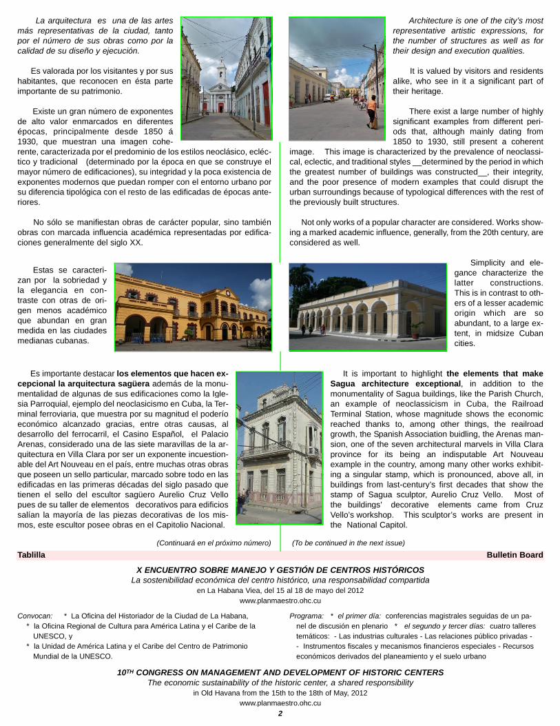
Etapa proyectual : Designing state
THE CITY OF HAVANA
POSTGRADUATE COURSE ON ENVIRONMENTAL DESIGN : TRILLO PARK IN THE
MUNICIPALITY OF CENTRO HABANA
Professor: architect Augusto Rivero Mas
Telephone: 83 77 237
Electronic mail address: [email protected]
Members: D. I. Liliana Alemán and architect Jorge Luis Marrero
Paper presented during the event titled “VII Jornadas Técnicas de
Arquitectura Vernácula del año 2010” held in Havana in the month of
March 2010.
The contents of the paper have not been completely included in our pub-
lication due to space limitations. It was received in Havana on that date.
Part Three and Last.
Conceptualization : Proposals : Analysis of the Surroundings
Without moving away from the concepts of integration and cohe-sion, the intervention proposal starts from the visual plans and per-spectives that make up the location and the resulting volumes.
Paying attention to the predominance of verticality and the lightand shade effects of door and window openings, balcony sequences,the skyline as determined by the parapets, grilles, mouldings, reliefsand textures, facades will be dealt with starting from the followingconcepts:
* To restore the identity of the facades according to the originaltypologies and styles.
* To deal with the current fragmentation of the openings makinguse of textures and colors as determined by the accepted solu-tion to the problems faced in each case.
* To emphasize the effect of light and shadow by means of colorin support of mouldings and balconies.
* To respect chromatic uniformity with reference to color saturationand the study of the introduction of more saturated shades inbuildings that, due to their formal value, deserve it.
* To selectively reproduce, using plastic materials, surface, as wellas reliefs, formal elements that reinforce the location’s uniformityof styles.
* To design murals for those flat surfaces that due to their signifi-cance and possibilities will help to emphasize the project’s hu-man scale. The virtual limit will be the predominant profile ofthe location’s surroundings.
Proyecto general : General project
DISTRIBUCION DE AREAS VERDES : GREEN AREAS DISTRIBUTION
MERCADO TRILLO / TRILLO MARKET
4
EL MALECON DE LA HABANA
Dirección General de Proyectos de
Arquitectura y Urbanismo,
Oficina del Historiador de la Ciudad
de La Habana.
Dirección de Proyectos Prado-
Malecón,
Calle Cuba 316 esquina a Obrapía,
La Habana Vieja, CUBA
Teléfonos: 86 47 773, 86 44 466
Direcciones electrónicas:
[email protected] y [email protected]
La información a continuación fue gentilmente facilitada por el arquitecto Abel
Esquivel, jefe del Taller del Malecón, en diciembre del 2010 y revisada por él
y Alejandro Rojas Vera en noviembre del 2011.
Edificio Residencial (comercio en planta baja)
Malecón # 559-561 / San Lázaro #562-564 e/ Lealtad y Escobar.
Arquitecta original: Mónica Soffi Díaz
Arquitectos actuales: Abel Esquivel ([email protected])
Alejandro Rojas Vera ([email protected])
Teléfono. 864 77 73.
Conceptualización
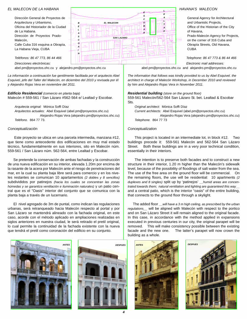
Este proyecto se ubica en una parcela intermedia, manzana #12,que tiene como antecedente dos edificaciones en muy mal estadotécnico, fundamentalmente en sus interiores, sito en Malecón núm.559-561 / San Lázaro núm. 562-564, entre Lealtad y Escobar.
Se pretende la conservación de ambas fachadas y la construcciónde una nueva edificación en su interior, elevada 1.20m por encima dela rasante de la acera por Malecón ante el riesgo de penetraciones delmar, en la cual su planta baja libre será para comercio y en los nive-les restantes se comunican 10 apartamentos (2 dobles y 8 sencillos)
subdivididos por patinejos (hacia los cuales se concentran las zonas
húmedas y se garantiza ventilación e iluminación naturales) y un patio cen-tral que es el "Oasis" interior del conjunto que se comunica con laplanta baja a través de un lucernario.
El nivel agregado de 3m de puntal, como indican las regulacionesurbanas, será retranqueado hacia Malecón respecto al portal y porSan Lázaro se mantendrá alineado con la fachada original, en estecaso, acorde con el método aplicado en ampliaciones realizadas ensiglos anteriores en nuestra ciudad, le será retirado el pretil original,lo cual permite la continuidad de la fachada existente con la nuevaque tendrá el pretil como coronación del edificio en su conjunto.
HAVANA’S MALECON
General Agency for Architectural
and Urbanistic Projects,
Office of the Historian of the City
of Havana,
Prado-Malecón Agency for Projects,
on the corner of 316 Cuba and
Obrapía Streets, Old Havana,
CUBA
Telephone: 86 47 773 & 86 44 466
Electronic mail addresses:
[email protected] and [email protected]
The information that follows was kindly provided to us by Abel Esquivel. the
architect in charge of Malecón Workshop, in December 2010 and reviewed
by him and Alejandro Rojas Vera in November 2011.
Residential building (store on the ground floor)
559-561 Malecón/562-564 San Lázaro St. bet. Lealtad & EscobarSts.
Original architect: Mónica Soffi Díaz
Current architects: Abel Esquivel ([email protected])
Alejandro Rojas Vera ([email protected])
Telephone. 864 77 73
Conceptualization
This project is located in an intermediate lot, in block #12. Twobuildings precede it: 559-561 Malecón and 562-564 San LázaroStreet. Both these buildings are in a very poor technical condition,essentially in their interiors.
The intention is to preserve both facades and to construct a newstructure in their interior, 1.20 m higher than the Malecón’s sidewalklevel, because of the possibility of floodings of salt water from the sea.The use of the free area on the ground floor will be commercial. Onthe remaining floors, the use will be residential: 10 apartments (2
duplexes and 8 singles) split up by ‘patinejos’ __humid areas are concen-
trated towards them; natural ventilation and lighting are guaranteed this way__
and a central patio, which is the interior “oasis” of the entire building,that connects to the ground floor through a skylight.
The added floor __will have a 3 m high ceiling, as prescribed by the urban
regulations__ will be aligned with Malecón with respect to the porticoand on San Lázaro Street it will remain aligned to the original facade.In this case, in accordance with the method applied in expansionsexecuted in previous centuries in our city, the original parapet will beremoved. This will make consistency possible between the existingfacade and the new one. The latter’s parapet will now crown thebuilding as a whole.
ANTES DESPUES ANTES DESPUES
ESC
OBAR
GERVASIO
LEALT
AD
AVE. ANTONIO MACEO (MALECÓN)
CALZADA DE SAN LÁZARO
BEL
ASCO
AÍN
LAGUNAS
50
3505
55
7
605
60
7609
613 611655
65
3657659
66
1
67
1
6676696
73
67
5677
S.BJosé Martí
681 679
682
68
0
678 67
6
668
66
6
664
658
66
5
674 672 670
66
3
662660
656
52
655 653657659661
663667669
671665
61
9 617 615
625617
624
622 620
618 616 610602614
612
608
60
6
60
46
03
601
611
615 6
03
607
605609
568 566564562
561559
55
8
55
6
55
4
552
560
57
1
569 567
561
565
557
555 553
559
511 509507
514 512 510
508
506
517
515
50
7
555 551
651
654
651
519513
55
1
60
1
B
E
L
A
S
C
O
A
I
N
EL MALECON
SAN LAZARO
E
S
C
O
B
A
R
L
E
A
L
T
A
D

5
Se propicia, la articulación análoga entre lo existente y lo nue-vo, con una expresión arquitectónica contemporánea (de ambas facha-
das nuevas) que mantiene los códigos fundamentales de la zona y lasfachadas existentes a través del ritmo recreado por las pilastras ado-sadas, la utilización de la verticalidad y misma secuencia de vanos, yse define el pretil (remate tradicional de la zona) con una moderna peromodesta marquesina por Malecón que, hacia San Lázaro es másprominente por la protección solar que proporciona ante su orien-tación casi al sur; se mantiene el usual balcón corrido que recibirámantenimiento por Malecón y en San Lázaro se sustituye el antepe-cho del balcón actual (no acorde con la fachada original) con una baran-da que propicie una favorable permeabilidad, y en el nivel agregado,se logra un asomo que permite recrear el balcón corrido tradicional.
EL CASTILLO DE LA PUNTA : EL BALUARTE DE QUINTANILLA
Arquitecto Juan Carlos Pérez Botello, vicedirector
Escuela Taller de La Habana, Teniente Rey 15, entre Oficios y
Mercaderes, La Habana Vieja, Ciudad de La Habana, CUBA
En el primer proceso de restauración, la cubierta del baluarte erade madera. La misma había alcanzado un grangrado de deterioro debido a las termitas. Estasúltimas encuentran un ambiente muy propicio enestos muros de mampostería y tapia. Es porello que, en esta ocasión, se determinó prepararun proyecto con bávedas de ladrillo. Tal proyec-to es mucho más compatible con los muros demampuesto y, por supuesto, más duradero.
Las nuevas bóvedas se harán de arcos deladrillo macizo con el sistema de bóvedas tabi-cadas aligeradas. Este sistema es el mismoque se empleó en la iglesia catedral ortodoxa ru-sa Nuestra Señora de Kazán en La Habana Vieja y que empleó Rafa-el Gustavino en la Gran Estación Central de la ciudad de Nueva York.
A corresponding coordination between what exists and whatis new is favored. Both new facades are to have a contemporaryarchitectural appearance in keeping with the basic regulations for thearea and the existing facades via the thythm recreated by the attachedpilasters, the utilization of verticality, and the sequence of openingsthemselves. The parapet (traditional low wall on top of the building) consists ofa modern but modest covering towards Malecón, whereas towardsSan Lázaro St., it is more prominent. This is due to the larger shade from
the sun it gives in view of the street’s almost southern orientation. The usualcontinuous balcony is kept. On Malecón, it will be repaired and, onSan Lázaro Street, a rail will replace its current parapet (it does not agree
with original facade.) and provide greater transparency. On the added floor,
an ‘asomo’ makes possible the recreation of the traditional continuous balcony.
LA PUNTA CASTLE : THE QUINTANILLA BASTION
Architect Juan Carlos Pérez Botello, subdirector
Escuela Taller de La Habana, 15 Teniente Rey Street, between Oficios
and Mercaderes Streets, Old Havana, the City of Havana, CUBA
At the time of the first restoration of the castle, the bastion had awooden roof. The roof had reached a high level of deterioration
because of termites. These insects find a veryfavorable environment in these masonry and‘tapia’ walls. For this reason, on this occasion,it was decided to design a project that makesuse of brick vaults. Such a project is more com-patible with the masonry wall and, of course,more lasting.
The new vaults will consist of solid-brickvaults constructed using the lightened bricked-up-vaults system. This system is the same onethat was used in Old Havana in the RussianOrthodox Cathedral Church of Our Lady of
Kazán and that Rafael Gustavino used in the Grand Central Station inNew York.
GOTICA... La Habana con un artículo que la precede, no Habana, La Habana, quiere decir que ella es exclusiva, no hay otra igual, no hay ninguna que
tenga su nombre, ni siquiera nombre parecido, es sólo y exclusivamente La Habana (Eusebio Leal, historiador de la ciudad, en el Templete, el 15 de noviembre del 2011)
EL PROCESO DE CONSTRUCCION : / THE CONSTRUCTIVE PROCESS :
JUAN CARLOS PEREZ BOTELLO, 5 JANUARY 2012 9:23 AM

6
“CREACION Y EVOLUCION HISTORICA DEL PASEO DE CARLOS III DE LA CIUDAD
DE LA HABANA” en el municipio de Centro Habana
Raquel Esteban Pinto y María de los Angeles Rodríguez Sánchez
Planificación Física - Cuba, núm. 1/2003, páginas 54 á 62.
Dirección electrónica: [email protected]
Este artículo se presentó como comunicación en el XXIX Congreso Nacio-
nal de Parques y Jardines Públicos, PARJAP 2002, celebrado en Salaman-
ca, en septiembre del mismo año.
Le agradecemos a Alejandro Elsici en Cuba y al arquitecto Secundino Fer-
nández y su hijo John Fernández, en Nueva York, las valiosas imágenes
que, aparte de las de los autores, ilustran este artículo en su totalidad.
Foto a la derecha: Manolo Sánchez Victores, 5 de diciembre del 2011 a la
1:17 pm : columna original llegando a Belascoaín.
Segunda continuación
Diseño y elementos del paseo
Según los datos aportados por los historiadores y algunos autoresde la época, la realización definitiva del Paseo Militar presenta algu-nas divergencias con el proyecto inicial ideado por Tacón. Comoejemplo de estas variaciones se pueden mencionar las dimensionesde la avenida, así como la distancia que separaba las diversas roton-das: la estructura del Paseo se componía de una calle central, desti-nada a carruajes, y dos laterales de uso peatonal, así como de cua-tro hileras de álamos blancos.
Su extensión era de 1 425 varas provinciales con una anchuraconstante de 60 varas. A lo largo de su recorrido se podían encontrarcinco glorietas, las cuales no eran equidistantes entre sí. (Cirilo Villaverde
señala q. el Paseo tenía una longitud de 2 000 varas con un ancho de 40 varas. VV.AA.
“Paseo pintoresco por la Isla de Cuba”. Ed. Habana, 1841. Edición facsímile, Miami, 1999,
p. 253)
En la Biblioteca Nacional de Cuba “José Martí” se encuentra eloriginal de un plano que Ramón de la Sagra9 realizó como proyectopara el Paseo de Tacón, considerado por algunos investigadorescomo un completo plan de áreas verdes con fines paisajísticos, dadoel amplio conocimiento de botánica, la flora y las condiciones climáti-cas de la Isla que tenía su autor. (9 Ramón de la Sagra, historiador y econo-
mista, ocupó, entre otros cargos, la dirección del Jardín Botánico de La Habana de 1827
á 1836 y fue el autor de la obra “Historia física, política y natural de la Isla de Cuba”).
Este proyecto firmado por de la Sagra no permite afirmar que fue-sen las ideas del Director del Botánico las que se llevasen a cabo enla realización del Paseo.
Este plano plasma un perfil del Paseo y una planta que representa
DEL “PLANO DE LA HABANA” POR JOSE MARIA DE LA TORRE, 1867
“THE CREATION AND HISTORICAL EVOLUTION OF PASEO DE CARLOS III OF THE
CITY OF HAVANA” in the municipality of Centro Habana
Raquel Esteban Pinto and María de los Angeles Rodríguez Sánchez
Planificación Física - Cuba, no. 1/2003, pages 54 to 62.
Electronic mail address: [email protected]
This article was read during the 19th National Congress on Parks
and Public Gardens, PARJAP 2002, that took place in Salamanca in
September of the same year.
We thank Alejandro Elsici, in Cuba, and architect Secundino Fernández,
and his son John Fernández, in New York, for the valuable images that, in
addition to those of the authors, illustrate the complete article.
Photo to the left: Manolo Sánchez Victores, December 5, 2011 at
1:17 pm : original column near Belascoaín Street.
Part Three
Design and elements of the Paseo
According to data provided by historians and some authors fromthe time, the definitive execution of Paseo Militar presents some dif-ferences with respect to the original project conceived by Tacón. Asan example of these deviations, the following can be mentioned: thedimensions of the avenue as well as the distance that separated thevarious circles: the structure of the Paseo consisted of a centralstreet, for carriage use, and two lateral streets, for pedestrian use, aswell as four rows of white poplars.
The length of the Paseo was 1 425 provincial varas, with a con-stant width of 60 varas. Along its route, five circles could be found,which were not equidistant from each other. (Cirilo Villaverde indicates that
the Paseo was 2 000 varas long and 40 varas wide.. VV.AA. “Paseo pintoresco por la
Isla de Cuba”. Ed. Habana, 1841. Facsimile edition, Miami, 1999, page 253.)
The original plan that Ramón de la Sagra9 completed as a proj-ect for Paseo de Tacón can be found in the “José Martí” National Li-brary of Cuba. His plan is considered by some researchers as a com-plete plan for green areas for landscaping ends, given the ampleknowledge de la Sagra had of botany as well as of the flora and cli-matic conditions of the Island of Cuba. (9 Ramón de la Sagra, historian and
economist, held, among other positions, the directorship of the Botanical Garden of
Havana, from 1827 to 1836, and was the author of the book “Historia física, política y nat-
ural de la Isla de Cuba”.)
This project, signed by de la Sagra, does not let us affirm that theideas of the Director of the Botanical Garden were the ones that wereconsidered in the execution of the Paseo.
This map captures the characteristics of the Paseo and a plan that
FROM “PLANO DE LA HABANA” BY JOSE MARIA DE LA TORRE, 1867
EL CASTILLO DEL PRINCIPEEL PASEO DE TACON
C
D
A.
D
E
B
E
L
A
S
C
O
A
I
N
LA QUINTA DE LOS MOLINOS
CALZADA
DE LA INFANTA
AL NO OBTENER EL PLANO DE LA SAGRA SE DECIDIO UTILIZAR EL DE DE LA TORRE EN SU LUGAR SINCE THE DE LA SAGRA MAP COULD NOT BE OBTAINED, THE DE LA TORRE MAP WAS USED INSTEAD

covers 129 lineal varas of same.Its design contributes some inter-esting ideas about how to plan aconcrete plantation based on thegrowth of the vegetation to im-prove the appearance of the placeand increase the shaded area.According to Felicita [sic] Chate-loin: de la Sagra planned trees infour rows, placed 3.5 varas apartfrom each other. In each row heformed a sequence of a temporarytree for three years, another forten, then again one for three and,finally, one permanent. This wouldrepeat itself along the Paseo.
In this manner, the more the tree grew in height and developed itsfoliage, its diameter, the trees would start to be eliminated every threeand ten years successively, until the time when only the permanenttrees would be left. This is probably the first road landscaping proj-ect, conceived in Havana, that made use of scientific knowledge.[Felicita (sic) Chateloin, op. cit., p. 172.]
A text of the time indicated that although the works had not beencompleted, 904 trees had been planted, and the number of vegetationspecies was higher than one thousand once the various planted bush-es were added to that figure. It added that the arboreous area wouldbe greatly extended at the completion of the Paseo. [Santiago Cancio
and others (editors), “Jardín Romántico”, R. Oliva Press, Havana ¿1835?, p. 127].
The Alameda started on the intersection of Calzada de la Reinaand that of Belascoaín, where the first circle was located. TheCarrara-white-marble statue of king Carlos III was placed in the circle’scenter. The statue was previously found in Paseo del Prado12; itsbase consisted of a carved-stone pedestal , 3.5 varas tall, placed onthree quadrangular steps. [12 About the creation of the statue of the monarch,
its description and previous location, see the articles by Raquel Esteban Pinto and María
de los Angeles Rodríguez Sánchez, “El Paseo del Prado de La Habana: evolución históri-
ca” and “El Paseo del Prado de La Habana: elementos constitutivos”, PARJAP, issues 26
and 27 (Spring-Summer), respectively.]
At the beginning and end of the alameda, and on each one of itssides, there were two stone columns crowned by marble lions. Onthe plinths of the ones at the entrance inscriptions were placed thatcommemorated the alameda’s construction dates. (See note on
page 8 )
As stated on the researched descriptions, this circle and the nextone were the only circles that were enclosed with iron railings and hadcircular carved-stone seats around them. In addition to these resting
areas, there were four rows ofstone benches between the firsttwo circles and under thealigned rows of trees alreadymentioned. In contrast, be-tween the second and third cir-cles, the paseo was furnishedwith two rows of stone stools,and then, from the third to thelast one, the paseo’s furnitureconsisted of ‘maleconcillos’ cov-ered by a grass known asbermuda.
At 200 varas far from the en-trance, the second circlethe second circle wasfound, ornamented with the La
7
120 varas lineales de éste, pero sudiseño aporta unas interesantesideas (de) como planificar unaconcreta plantación, basada en elcrecimiento de la vegetación, paramejorar el aspecto del lugar y darun mayor volumen de sombra.Según Felicita [sic] Chateloin: dela Sagra planeó árboles en cuatrohileras espaciados a 3,5 varasunos de otros; en cada alineaciónformó un ciclo de un árbol provi-sional por tres años, otro por diez,de nuevo uno por tres, y por últimouno permanente, repitiéndose estoa lo largo del Paseo.
De manera que en la medida del crecimiento del árbol en altura ydesarrollo del follaje, en diámetro, se irían eliminando los árboles a lostres y diez años sucesivamente, hasta quedar los permanentes.Este es probablemente el primer proyecto de paisajismo vial con apli-cación de conocimientos científicos que se hizo en La Habana.[Felicita (sic) Chateloin, op. cit., p. 172].
En un texto de la época se comenta que aunque no se habíanconcluido las obras, se habían plantado 964 árboles y que pasabande mil las especies vegetales al agregarse a éstos los diversos arbus-tos colocados, y añadía que la extensión arbórea se ampliaría en granmanera a la finalización del paseo. [Santiago Cancio y otros (editores),
“Jardín Romántico”, Imprenta de R. Oliva, La Habana ¿1835?, p. 127].
La Alameda comenzaba en el cruce de la Calzada de la Reina conla de Belascoaín, donde se hallaba situada la primera glorieta encuyo centro se ubicó la estatua, en mármol blanco de Carrara, del reyCarlos III, que anteriormente había estado emplazada en el Paseo delPrado12; su base era un pedestal de sillería de 3,5 varas de alturaasentado en tres gradas cuadrangulares. [12 Sobre la creación de la esta-
tua del monarca, su descripción y su anterior ubicación véanse los artículos de Raquel
Esteban Pinto y María de los Angeles Rodríguez Sánchez, “El Paseo del Prado de La
Habana: evolución histórica” y “El Paseo del Prado de La Habana: elementos constitu-
tivos”, PARJAP, números 26 y 27 (primavera-verano), respectivamente].
Al principio y final de la alameda, y a cada uno de sus lados, habíados columnas de piedra coronadas por dos leones de mármol. Enlos basamentos de las de la entrada se colocaron las inscripcionesque conmemoraban las fechas de realización de este paseo. (Véase
nota en la página 8)
Según consta en las descripciones consultadas, esta glorieta y lasiguiente fueron las únicas que contaron con enverjados de hierro yasientos circulares de sillería a su alrededor. A estos espacios dedescanso se sumaban cuatro fi-las de bancos de piedra, com-prendidas entre las dos prime-ras rotondas y situadas bajo lasalineaciones arbóreas ya men-cionadas, mientras entre la se-gunda y la tercera glorietas elpaseo estaba equipado con dosfilas de banquetas de piedra, ydesde la tercera hasta la últimael mobiliario del paseo consistíaen unos maleconcillos cubiertosde hierba llamada bermuda.
A unas 200 varas de laentrada se encontraba la se-gunda glorieta ornamentada
GRABADO DE MIAHLE, 1838

8
con la fuente de La Columna de Ceres. Sobre un pedestal cua-drangulardescansaba una columna de 23 varas, rematada por unaescultura de mármol de tamaño natural de esta diosa griega. Al-rededor de la mencionada columna se ubicaron cuatro pedestales, denueve pies, que sostenían respectivamente cuatro figuras alegóricasrepresentativas de las cuatro estaciones. Rodeando el conjunto seconstruyó un vaso de piedra de un metro de profundidad y 25 varasde extensión coronado por una verja de hierro. El agua de la fuentesurgía de ocho surtidores con formas de cabezas de león en relieve,situadas en los mencionados pedestales.
La tercera rotonda, a 522 varas de la anterior, estaba ubicada enel cruce del Paseo con la calzada de Carraguao, después denomina-da de la infanta María Luisa Fernanda. En ella se colocó la fuentellamada de Los Aldeanos or de las Frutas, que se componía de unpequeño templete con columnas adosadas, de cinco varas de altura,y que se hallaba situado sobre un pedestal cuadrangular.
Las columnas estaban rematadas por unos jarrones con frutas yla parte central finalizaba con una copa. Rodeando el templetehabía cuatro figuras que representaban: la fuereza, la hermosura, lapoesía y el amor. Todo el conjunto estaba realizado en mármol. Elagua vertía por ocho conductos al vaso, que era de forma elíptica yque estaba rodeado de una verja de madera. El nombre de la fuentele venía dado por sus adornos frutales.
La cuarta glorieta se encontraba a unadistancia de 200 varas y estaba adornada conuna tercera fuente de cinco varas de altura, ala que se le dio el nombre de Los Sátiros o deLas Flores. Su parte central era similar a laanterior, pero sin almohadillas, y estabarematada por una copa de piedra y ornamen-tada con pilastras, en dos de las cuales habíaunas figuras de mármol representando faunoso sátiros, y en las otras dos unos leones dur-mientes. La taza era circular y la adornaban cuatro vasos con flo-res, sobre sus respectivos pedestales.
El conjunto se rodeó de una verja de madera y en el exterior secolocaron postes y cadenas que impedían el acceso. Posterior-mente, la urna central fue sustituida por una figura de fundición querepresentaba a la diossa Pomona. En esta glorieta desembocabaun camino que conducía directamente a la casa de recreo de la Quin-ta de los Molinos, donde como se ha comentado, Tacón ubicó la resi-dencia de verano de los Capitanes Generales.
A las faldas de la fortaleza del Príncipe se encontraba la últimarotonda, que era la más frondosa de todas al encontrarse rodeada deálamos, pinos y (cañasbravas). En su centro se elevaba la fuentede Esculapio, con su figura en mármol no muy bien labrada, que seasentaba sobre un pdestal cuadrangular de dos varas de alto; en lataza octogonal vertían cuatro surtidores de agua y se hallaba rodea-da por una verja de madera. Posteriormente, el vaso fue sustituidopor uno de forma circular.
En relación con esta fuente, tanto José Antonio González Lanuzacomo el ingeniero Mariano Carrillo de Albornoz destacaron lo inade-cuado que resulta la colocación de una estatua dedicada a Esculapio,dios de la Medicina, en el camino que conduce al cementerio.
(Continuará en el próximo número)
.
Columna de Ceres fountain. A 23 varas column was restingon a quadrangular pedestal, crowned by a natural-size marblesculpture of that Greek goddess. Around the mentioned col-umn, four nine-foot-tall pedestals were placed. They were respec-tively supporting four figures which symbolically represented thefour seasons. Surrounding all of them, there was a stone‘vaso,’ one meter deep and 25 varas long, crowned by an iron rail-ing. Water from the fountain ‘vaso’ gushed from eight pumps shapedas lion’s heads in relief. The latter were placed in the mentionedpedestals.
The third circle. was 522 varas far from the previous one, andwas located in the intersection of the Paseo and Calzada de Ca-rraguao, later renamed Calzada de la Infanta María Luisa Fernanda.The fountain called Los Aldeanos de las Frutas was placed here. Itconsisted of a small shrine with attached columns five varas tall. Itwas placed on a quadrangular pedestal.
Vases with fruits crowned the columns and a cup put the finishingtouch to the central part. Four figures surrounded the shrine. Theyrepresented: strength, beautifulness, poetry and love. Everythingwas made of marble. Water flowed from eight conduists to the vase,in the shape of an ellipsis. The vase was surrounded by a woodenrailing. The use of fruits in the fountain decorations were the reasonfor its name.
The fourth circle’s location was 250 varasfar from the previous one. A third fountain,five varas tall, ornamented it. It was namedLos Sátiros or Las Flores. The fountain’s cen-tral part was similar to the previous one butwithout bolsters. A stone cup crowned itand was ornamented with pilasters. On twoof the latter there were some marble figuresdepicting fauns or satyrs and, on the other two,some sleeping lions. The vase was circular
and decorated with four vases with flowers on their respectivepedestals.
A wooden railing surrounded the whole and, on the exterior, postsand chains were placed that prevented access, Later, the central urnwas replaced by a cast figure representing the goddess Pomona. Aroad that directly led to the country house in Quinta de los Molinoscame out onto this circle. As it has already been said, Tacón placedthe summer residence of the Captain Generals in Quinta de losMolinos.
The last one of the circles was found on the sides of El PríncipeFortress. It was surrounded by poplars, pines, and bamboos; itsvegetation was the thickest of all the circles. In its center, theEsculapio fountain was found with a not-too-well-sculpted marble fig-ure of Esculapio. The figure was placed on a two-varas-tall quad-rangular pedestal. Water flowed from four conducts. The vase wassurrounded by a wooden railing. It was later replaced by a vaseshaped like a circle.
In relation to this fountain, José Antonio González Lanuza, as wellas engineer Mariano Carrillo de Albornoz, have called attention to theinadequacy of placing a statue honoring Esculapio, god ofMedicine, on the road that leads to the cemetery.
(To be continued in the snext issue.)
“LA ARQUITECTURA COLONIAL CUBANA”, JOAQUIN E. WEISS, PA. 364